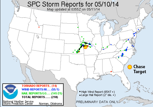
At 21Z a surface trough will stretch from North Dakota to northeast Kansas, migrating slowly southeast. A cold front will drape from the Nebraska/Iowa border, across east Kansas and into northwest Oklahoma where it transitions to a dryline southward across west Texas. Mid to possibly upper 60 dewpoints will be pushing northward into northern Missouri on 15-20 kt surface winds. As convection fires from 18Z-21Z, MLCAPE values could reach 3000 j/kg east of the front, with NAM aggressively plotting 4000 j/kg in west-central Missouri.
Mid/upper level support takes the form of only slightly amplified flow with pockets of 40 kts at 500 mb across the central plains and into the midwest. The warm sector appears to get its best support across the northeastern three-fourths of Missouri with 50 knots of bulk shear over northwest and north central parts of the state. 0-1km SRH reaches 150 m2/s2 over the northwest quadrant of Missouri as well by 00Z.
NAM forecasts convection firing in this better zone by 21Z with open, clockwise forecast hodographs showing up in both NAM and GFS. Lid Strength Index opens a brief opportunity for surface based storms in the 21Z time frame in this northwest Missouri as well, so placing my target at Odessa, east of Kansas City.
Results
Nearest Tornado Report: 16 Miles North-northeast Nearest Severe Report: Same
Numerous severe storms erupted along the cold front and dryline around 20Z with a few supercells turning right and strengthening. The one that passed just north of Odessa generated a few tornado reports—the nearest 16 miles to the north-northeast.
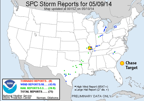
I didn’t have a lot of time to prepare this. I targeted a location east of the cold front in southeast Missouri where the H5 speed max would provide bulk shear in the 40-50kt range between 21Z-03Z. NAM forecasts dew points in the mid 60s in southwest Missouri with CAPE reaching 2000 j/kg. 0-1 km SRH is not good, reaching maybe into 100 m2/s2 after 00Z, so I don’t see more than a very odd chance at tornado potential. NAM forecasts better parameters and reflectivity further north than GFS, so I tried to split the difference between them.
Results
Nearest Tornado Report: None Reported Nearest Severe Report: 16 Miles North-northwest [Hail: 1 inch] || 25 Miles Northeast [Wind: Roof off house]
Insolation had an early start in my target area, which helped several severe warned and two tornado warned storms pass near Fredericktown. A wind report 35 miles south had this to say:
3 S GREENVILLE Wind Report County, State: WAYNE, MO (marker location is approximate) Lat.: 37.08, Lon.: -90.45 Time: 2014-05-09 20:00 UTC Wind Speed: Unknown TREE LIMBS DOWN AND DAMAGE TO CAMPER AWNINGS AT THE OLD GREENVILLE CAMPGROUND. UNCONFIRMED REPORT OF FUNNEL CLOUD ASSOCIATED WITH DAMAGE. DAMAGE PATH ESTIMATED AROUND O (PAH)
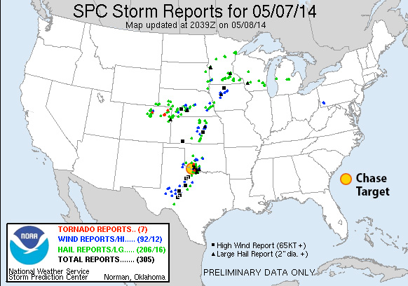
Looking at the southern portion of this setup: it features a fairly neutral-tilt trough over western US with 50-60kt 500 Mb speed max edging eastward over the Panhandles/western Oklahoma/northwest Texas/southwest Kansas. The 18Z NAM forecasts 40-50kt bulk shear over northwest texas to northwest Oklahoma by 00Z and increasing thereafter. The 18Z GFS spreads that out more, but pushes it further northwest. An elongated surface trough is forecast to tighten up from northeast Colorado to eastern Nebraska with a dryline retreating westward during the afternoon/evening and ending up at 00Z from western Iowa through central Kansas, southwest Oklahoma and south from there into Texas with mid 60 dewpoints in place. CAPE values range from 2000 (GFS) to 3000 (NAM) j/kg east of the dryline by mid-late afternoon. By 00Z, GFS breaks out convection north of the Red River while NAM plants south of the Red River. Both models/areas feature widening hodographs toward and after sunset. NAM features EHI building from 1.0-3.0 around and south of Vernon Texas from 00Z-03Z with 0-1km SRH approaching 300 m2/s2 by 03Z. LCLs start to drop toward 1,000 meters from 00Z-03Z as well.
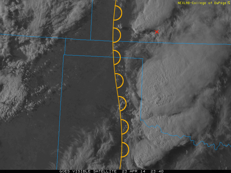
[Update 1515Z:] Latest NAM, HRRR and RAP reflectivity forecasts are showing some differences in where convection will initiate and strengthen. 06Z and 12Z NAM fires things up right over my target area. RAP and 12Z HRRR however are lighting up further east at mid afternoon with HRRR firing a weaker second round over my target area a couple hours later. It seems like HRRR is anticipating the dryline sitting further east around 21Z when convection initiates, and then the dryline starts retreating right after that. I’m interested to see if SPC nudges the risk area eastward or not. The difference is about 50 miles, so if I were there, I’d be pleased to just sit in my current location, watch the dryline mark itself out, and then adjust if needed as cumulus gets more agitated.
Results
Nearest Tornado Report: 30 Miles Southeast Nearest Severe Report: 18 Miles East-northeast [1.5 Inch Hail]
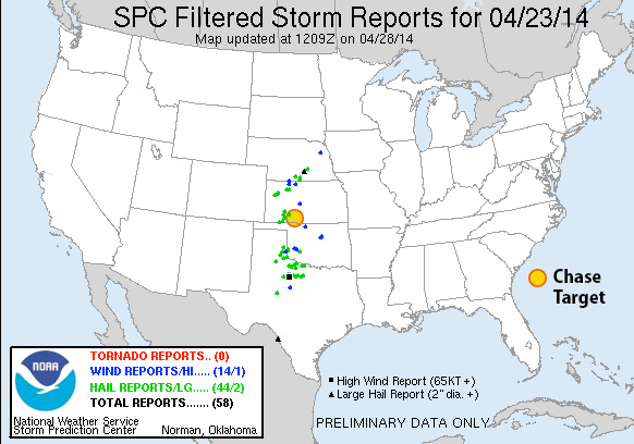
Storms that fired near southwest Oklahoma did fairly well toward 00Z with a tornado-warned cell crossing the Red River near my target area. Apparently there was a spotter report of a tornado near Burkburnett, but I haven’t seen it posted to SPC storm reports as of 0500Z.
[Update May 8, 2014:] SPC is still updating storm reports, and have now plotted two new tornado reports: 30 miles southeast of my target, near Burkburnett, and 40 miles north-northeast, in the Wichita Mountain Wildlife Refuge.
A surface low is forecast to elongate over Wisconsin and Ohio with a cold front draping through eastern Tennessee through the Florida panhandle and migrating slowly eastward. The upper low will be over Iowa with 70 kt 500 mb flow flow aligned over cold front with 35-40 kts extending out over the warm sector to the east leading to 35-40 kts of bulk shear in that area.
Dewpoints from 65-70 will be in place from Florida through east Virginia. NAM and GFS paint different pictures of early convection/cloud cover/surface heating and subsequent CAPE values. If GFS pans out, 2000 j/kg CAPE will build from the Florida panhandle through central Georgia and South Carolina. If NAM pans out, some smaller pockets of 2000 j/kg will build along coastal Georgia/far south South Carolina. RAP so far looks like it’s splitting the difference between NAM and GFS on the situation.
00Z NAM paints large pockets of 100-150 m2/s2 0-1km SRH through central Georgia and more broadly north of there, reaching over 200 m2/s2 from western North Carolina and Virginia. Timing of the convection is variable across the models, could take the form discrete storms, a line, a broken line, a boggy mess. The best compromise of moderate CAPE, SRH, and bulk shear seems to be at the Georgia/South Carolina border close to the coast.
[Edit 1500Z:] Oh man…there goes my forecast area again, immersed in another MCS outflow & anvil festival. I may pull the plug on the chase case opp in the next hour.
[Edit 1530Z:] Alright, I’m going to leave my target in place and let the chips fall where they may. Current satellite trend looks like anvil cover is thinning gradually, and radar appears to show the MCS being progressive, instead of squatting over one area like yesterday. Probably wishful thinking, but maybe there will be enough clearing for the airmass to recover. Or maybe I’ll see a random wind report.
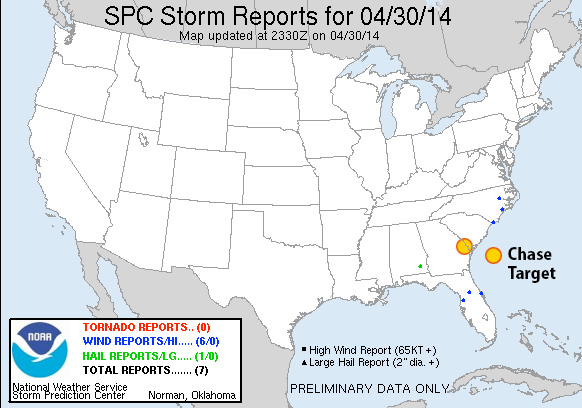
Results:
Nearest Tornado Report: None Nearest Severe Report: 198 Miles Northeast [Wind Report]
MCS Forecast Botch #2. Between today, yesterday, and my 2011 experience, this is definitely a weakness for me. What do I look for to say, yeah—the models aren’t picking up that today’s storms are going to get comfy and build a cold, wet nest all over tomorrow’s boundary layer? It doesn’t just put a hole in the setup where you can drive a couple hours and be out of it—the stable blanket lays over multiple states, and may just be a situation of deciding to start the long drive home the night before if you know it’s going to pan out that way. Research.
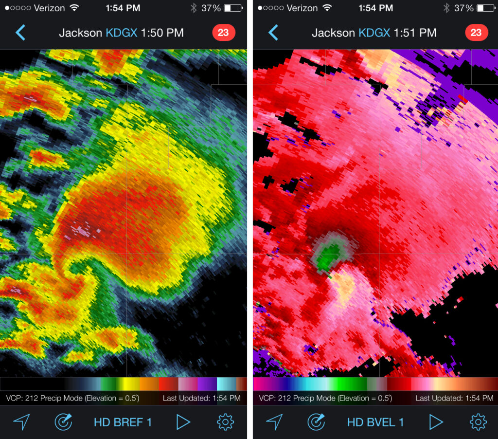
Upper level low over easter Iowa with 70-80 kts of flow over Louisiana/Mississippi/Alabama. Surface low is stacked right under its upper level partner. A cold front wraps through western Kentucky/Tennessee, northwest Mississippi and northern Louisiana at 18Z and pushing slowly southeastward during the afternoon. Upper 60 to 70 degree dew points are in place early with surface winds veered more strongly the further north you go approaching the front. CAPE values over the southeastern two-thirds of Mississippi, boot of Louisiana, and west-central Alabama start off over 3000 j/kg at 18Z and get eaten away by convection as the day goes on. Bulk shear over this strong instability is over 60 knots early on but relinquishes its hold over most of southern Alabama by late afternoon. 0-1km SRH is in the 150 m^2/s^2 over the southern third and a central pocket of Mississippi and floats ahead of developing convection. EHI is pegged over 3 in those central and southern pockets of Mississippi at 18Z when convection is heating up. Convective models show an early start to storms with supercells forming by midday in Mississippi and moving into Alabama during the afternoon. This is still early, messy convection and difficult to untangle options.
[Edit/Update 2230Z:] An ongoing MCS from yesterday’s storms on the gulf coast has not given up all day. Outflow and massive anvil cirrus has kept the southern two-thirds of Alabama and southeastern quadrant of Mississippi from heating up and reaching forecast instability. Storms have been trying to get going ahead of the cold front across Mississippi—much later than anticipated—but struggling much of the past couple hours. One storm about 70 miles southeast of my target area has picked up a tornado warning and is moving roughly eastward. It’s pretty strung out, the velocity couplets look anemic to my eye, and it’s not moving into better instability. So hard to say if it will last long.
Results:
Nearest Tornado Report: 632 Miles East-northeast …ehhh, probably ridiculous I’m tallying that… Nearest Severe Report: 64 Miles West-southwest [1 Inch Hail]
It’s amazing how soundly the non-stop MCS on the gulf coast turned the severe risk around for the region. Reminds me of May 11, 2011, when I woke up from the roach motel in Pratt, Kansas, on theoretically the strongest setup of the trip, to find an unexpected MCS and inbound anvils from Texas completely erasing the storm environment. It sure is a lot better to tank a forecast from home than 800 miles out! (The tornado-warned cell that was approaching Paulding did drop some meager hail with a couple reports 64+ miles out.) It’s a great relief all around that communities in the south got a reprieve from the last couple days of ruthless weather.
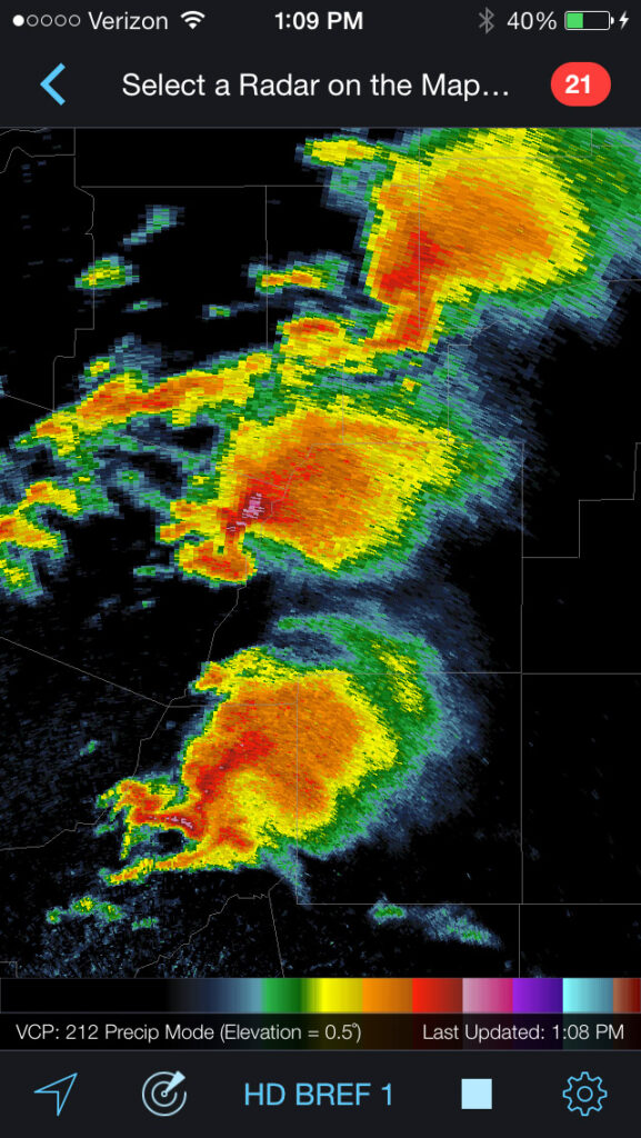
The closed upper low over eastern Kansas/Nebraska won’t have moved much in 24 hours. The surface low is pretty closely stacked at the Nebraska/Iowa border with a cold front/dryline arcing along eastern Missouri, Arkansas and Louisiana. Organized convection is forecast (per NAM) to start firing up around 15Z along the western Mississippi border. CAPE grows toward 2000+ j/kg ahead of this convection, better the further south you go, but capping appears to be a challenge and may prevent surface based convection. Upper air support is in good shape, at 60 kts early on. There is no standout location to me, other than staying north of heavier capping, but still south enough enough to find better instability. Forecast reflectivity and precipitation is a mess and difficult to interpret. SRH gets better as the day goes on, so trying to position a bit further east to give the line of storms time to take advantage of that. Once again, not an area i would chase, and definitely a setup I’m even less comfortable forecasting a chase target.
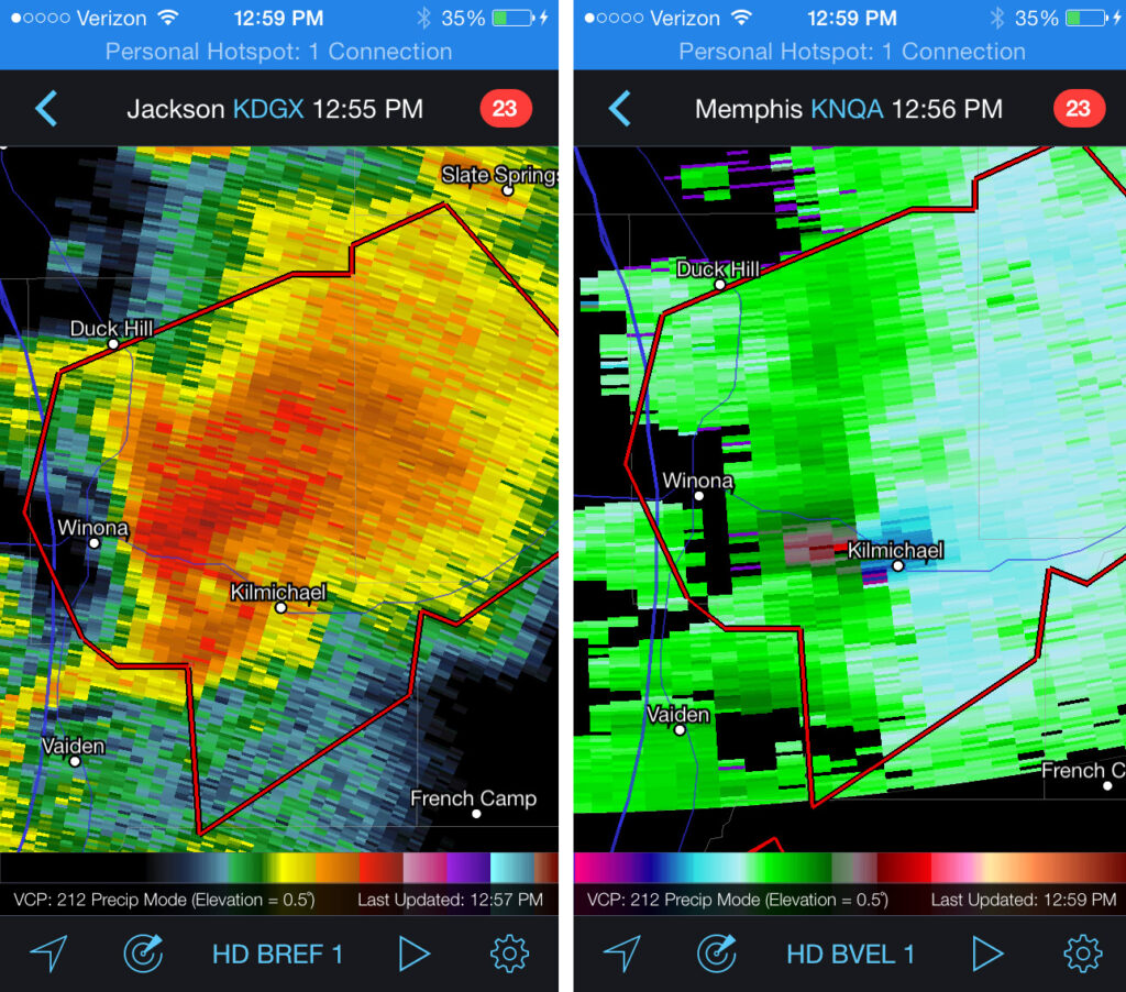
[Edit/Update 1745Z:] This morning, HRRR was forecasting 2 rounds of convection moving through Mississippi at 18Z and 23Z. Watching radar at 1730Z that first round is definitely firing up. There has been clearing ahead of it and surface heating underway. In particular, a serious looking cell erupting near Indianola. If I were chasing in this crazy terrain, I would be heading north to meet it near Grenada. And then there’s round to toward late afternoon. Hoping people are considering locations of shelters and listening to weather alert radio or TV!
[Edit/Update 1900Z:] A string of several tornado warned supercells have formed from north-central through west central Mississippi. Really hazardous situation. With 40-50 mph storm motions to the east-northeast, I would probably have had opportunity to briefly pace two or three of the northern storms along SR 8 and 9, north of my Kilmichael target then down to Euporea and Hwy 82 before letting the line pass.
[Edit/Update 1940Z:] Kilmichael is now in the direct path of the velocity couplet of a tornado-warned cell. Really hope folks are getting to shelter. I would likely make my way west on Hwy 82 and be ready to fly back east as it crosses the highway, and prepared for it to turn right with a south escape at Stewart.
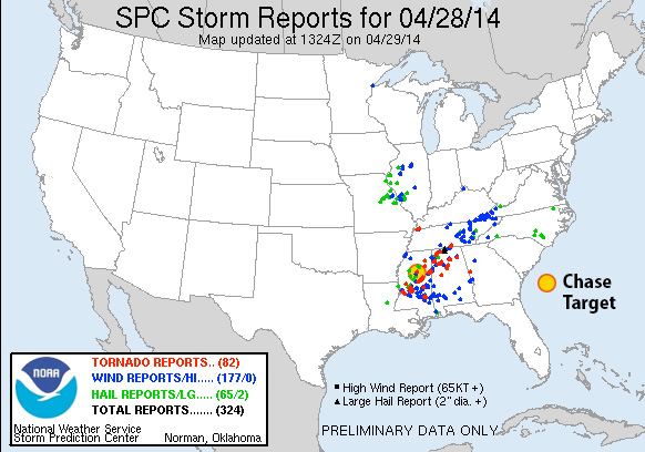
Results:
Nearest Tornado Report: 8 Miles North-northeast Nearest Severe Report: Same
A lot of strong, isolated supercells across Mississippi today with several communities hit. One of the early, northern cells I was tracking did generate a couple tornado reports just north of Kilmichael.
Another long track tornado 38 miles to the southeast generated 5 reports before winding up in Louisville. Unclear if that’s the same one that ended up in Columbus later in the afternoon/evening.
The radar presentation of three of the supercells over the center of the state by midday was unbelievable.
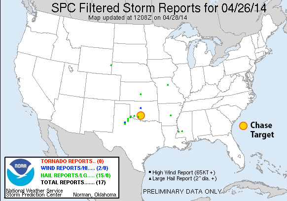
A surface low over the Kansas/Nebraska border drapes a dryline across eastern Kansas/Oklahoma/Texas. A broad zone of 3000+j/kg CAPE in E TX grows thinner by 00Z, but broad 2000-2500 j/kg reaches into the southwest half of Arkansas and throughout Louisiana. A negatively tilted upper level trough sweeps 65 kt flow over the dryline and warm sector during the course of the afternoon and evening leading to 60kt of deep layer shear. Large areas of 100-250 m^2s^2 SHR broadening east of the dryline as the afternoon progresses into evening particularly centered over the majority of Arkansas. NAM forecast convection kicks off by 18Z and effects the SW half of Arkansas through afternoon and evening with LCLs down to 250-500 meters and impressive hodographs. I’m positioning at Malvern for best reach at forecast convection within these parameters.
One big challenge I see is the cap opening up really early—before 18Z—with Lid Strength Index below 1 and into negatives over much of Arkansas. Early convection could sap boundary layer moisture, but models still forecast large areas of 65-70 degree dewpoints and 2000+ j/kg CAPE into the evening. I would not chase this area or setup in actuality—terrible chase terrain. Although storms should not be traveling too fast.
Results
Nearest Tornado Report: 41 Miles Northeast Nearest Severe Report: 31 Miles Southeast (Wind: Downed Trees)
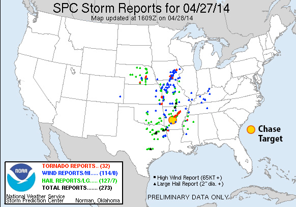
This setup led to a terrible situation in Arkansas. As of 04Z, the only tornado reports in Arkansas have come from a long track supercell that hit numerous residential areas, and caused enormous damage in the towns of Mayflower and Vilonia resulting in at least 10 deaths. I was watching this storm on Radar Scope earlier in the day when it first formed, got a severe warning, then developed a low level couplet. I had to log off before it received a tornado warning. If I were, by some bizarre reality, actually chasing in the jungle today, I probably would have made an attempt to pace this storm along the northwest side of Little Rock—not that I would have found a clear view through hills and trees in any case. Not a good place to be with storms like this. My thoughts and sympathies go out to all affected by this storm.
This is the first of several severe weather days that have had storm chasers on pins & needles for the past week. As the first day has drawn closer, the setup has looked less and less ideal, with the best upper level dynamics arriving later and later. I’m on overload from too many things to wrap up tonight, so this will be pretty basic:
Trying to find the best compromise between available instability, breakable cap that will permit surface based storms and some hope of seeing higher bulk shear from the lagging trough. NAM and GFS are forecasting precipitation after dark in central or southwest Oklahoma where CAPE is forecast around 3000 j/kg and maintaining 2000+ j/kg after sunset with 65 degree dewpoints per NAM and GFS. RAP laughs heartily at this however and wants to mix it out and you are lucky to get upper fifties. If NAM and GFS hold a little of their own, the Southwest/West-Central Oklahoma area corresponds to a Lid Strength Index below 1 for hopefully surface based storms. If that takes place, forecast 0-1 km SRH could rise from 100 to 200 m^2/s^2 with nice open clockwise hodographs.
Results:
Nearest Tornado Report: None Nearest Severe Report: 112 Miles West (1.25 Inch Hail)
Bah. What a sad setup. Moisture definitely tanked, mixed out, and got strongly capped. What did manage to form was mainly centered in Texas right at the SW corner of Oklahoma, but got choked off before it could get any further east. [Edit:] A couple more hail reports came in around 10Z that morning, one of which was 24 miles from my target area. Reports from 0530-1200Z don’t get tallied at the Storm Chase Game site, theorizing that people should be getting sleep from Midnight through 7 AM I imagine 🙂
A dryline reaching northward from the eastern panhandles will be the focus of convection starting possibly around 21Z. Bulk shear is forecast to increase to around 50kts into late afternoon, early evening along the dryline from the eastern Texas Panhandle into west central Kansas. CAPE will reach up to 2000 j/kg in this area. 0-1km helicity may reach 100 m^2/s^2 during the afternoon, and jump over 200 by sunset. LCLs will be high with inverted-V Skew-T profiles, so high-based storms with a tendency toward gusting out and reduced likelihood of tornadoes, but the possibility is still there, with wide-open, clockwise curling hodographs. NAM, GFS and RAP models show some differences in best position of these parameters, but the best overlap so far seems to be just north of the KS/OK border, east of the dryline.
Results:
Nearest Tornado Report: None Nearest Severe Report: 36 miles NW [1.5 Inch Hail]
By morning, HRRR and RAP forecast reflectivity, CAPE, low-level SRH had all pointed further south than my target area: mainly along the Texas Panhandle/Oklahoma border. Typical of my evening-before-skills: I would have left myself with a 100-150 mile drive the next morning. Anyway, there was still hope for more limited convection up in my standstill target area, but it was a lot less promising. Storms ended up firing as expected along the dryline after 21Z but the greatest activity was just as suggested by HRRR. A few small storms finally did gain some momentum further north, with my target area tucked in the cirrusy realms between. By some miracle, a couple 1.5-inch hail reports came in within 50 miles, so I picked up a consolation prize for that. Storms further south looked a lot better, and reports of rotating wall clouds did come in. However, supercells that formed were apparently high-based, and those that drifted into Oklahoma did not stay isolated, forming unproductive clusters insttead. As of 03Z, no tornadoes had been reported.
A weak surface trough is forecast to meander along the west Texas Panhandle/eastern New Mexico with a dryline forming east of this feature, drifting slightly eastward during the afternoon, and then sharpening and retreating westward after sundown. My target area is at the northern edge of 500mb short wave energy, along the dryline with bulk shear from 40-50 kts. I was looking for a spot where sufficient shear overlaps the dryline and better forecast CAPE values near 1500 j/kg as dew points reach 55-60°F. Better 0-1km helicity resides further east, but does not correspond with best instability until after sundown. As the LLJ increases after 00Z, a chance for better lower level winds may produce a limited tornado threat in this area with NAM forecasting convection where 0-1km EHI increases over 1.00.
Results:
Nearest Tornado Report: 243 miles NNE Nearest Severe Report: 234 miles NNE [2.75 Inch Hail]
No severe reports within a hundred miles of my target. A couple severe-warned storms went up in the area, but failed to produce anything worth reporting. A very nice supercell did go up further north near Childress, TX, and brought in loads of hail and wind reports, along with a brief tornado. I didn’t have that area pegged as having enough bulk shear, but it looks like it managed to pull it off. Meanwhile, further south where upper levels looked better, my first guess is that there wasn’t enough low level convergence to fire and sustain storms, as well as the first half of the day being dominated by a stratus layer that took too long to burn off.
As the Spring severe weather season rolls around, I like to work out the kinks in my forecasting and chasing strategy by running virtual chases on a few select days with severe potential. I’ll pick a target area for the morning of, drop a pin in Google maps, check conditions as the day progresses, and adjust my position, then commit to a storm and use the map time estimates to see if I can be in position for a supercell and possible tornadoes.
Taylor Campbell is a chaser who has set up a website called ‘Storm Chase Game’ at stormchasegame.com. The damage that severe storms cause is no game. However, the format of the site seems like good practice for chasers trying to gear up and stay in practice for forecasting during severe storm season. A little competition can help take the process seriously and commit to a forecast and target area. Unfortunately, you can’t adjust position during the day as you normally would while chasing, but that would probably be impossible to manage for that kind of format. Anyway, I’ve got an account there and have virtual chased a couple setups near the north-central Oklahoma border with Kansas on April 2 and northwest Arkansas on April 3. I picked up some severe hail and wind reports on those, but no tornado reports.
I figured, if I can keep up with it, I’ll post my abbreviated forecast and positions here and whether it panned out.
So for tomorrow: April 13, 2014
A triple point is forecast to set up in western Oklahoma and drag a dryline eastward over the course of the afternoon while a cold front drops in from Kansas. The dryline looks to stay intact during peak heating and convection development before the cold front mashes it into linear storms during the evening.
I’m positioning at Sapulpa, Oklahoma, southwest of Tulsa. Timing of shortwave energy will be crucial. This is a compromise between NAM and GFS. I will be positioning east of triple point for where there is likely to be better directional shear as convection erupts and prior to arrival of cold front. Bulk shear will hinge on the shortwave and could range from 30-45 kts in this area. NAM is forecasting 0-1km SRH around 175 m^2/s^2 ahead of storms moving through from 21-00Z with CAPE values from 2000-2500 j/kg. Normally, I wouldn’t chase this area due to terrain and urban environment. Hoping people in eastern Oklahoma stay tuned to weather radio/TV tomorrow and get to shelter if tornado-warned storms move through in the afternoon/evening.
[Edit:] With more recent runs of NAM, the cold front is proceeding further south during the afternoon and better instability also further south. Revised my position south west of the original location to Prague, Oklahoma.
Results:
Nearest Tornado Report: 130 miles SW Nearest Severe Report: 13 miles SSE [1 Inch Hail]
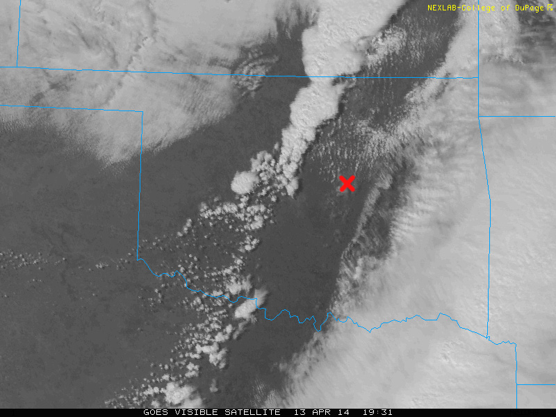
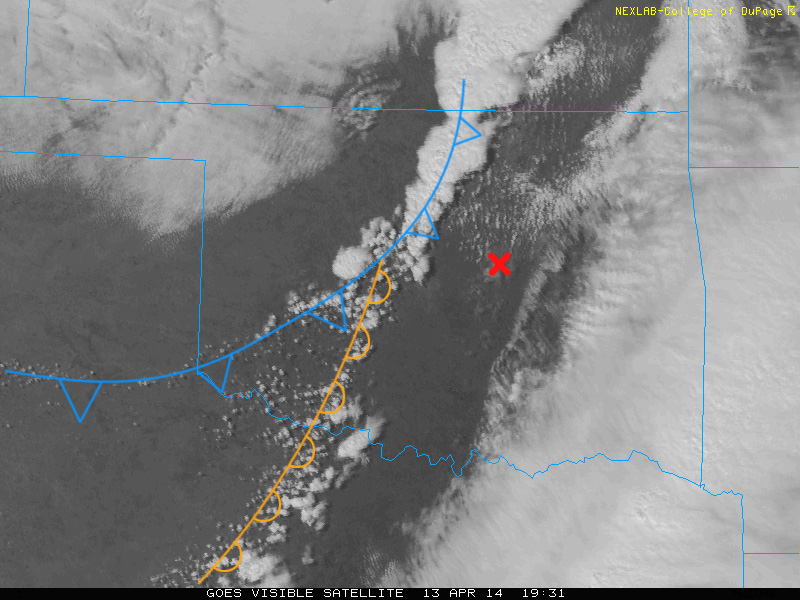
I’m pretty easily deceived by what I think I see happening on model forecasts vs. what actually takes place when it comes to cold front interference…as in how fast it moved through and lined out storms in northern two-thirds of Oklahoma. Morning convection forecasts also showed better chances of convection along the dryline into north Texas. If I had actually engaged in the misery of chasing eastern Oklahoma, those AM model runs, plus this satellite view would have sent me south of my original target:
Despite foiling my theory for chase targeting for the day, I think that satellite view is awesome. Once midday heating and convergence gets going, the boundaries start to get marked out by cumulus. This is a great view of the cold front rushing southward and overtaking the dryline while strengthening convection zippers southward along the cold front. More isolated storms eventually got going further south along the dryline where the cold front wasn’t messing things up as early, with a tornado report about 18 miles east of Duncan, OK. Besides a couple tornado reports in Iowa and east Texas, that was it for tornadoes. I did pick up a few hail reports inside my game radius, but not the part of the setup I was after.
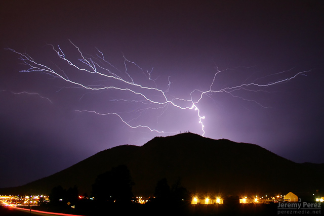
The 2013 Southwest Monsoon season still has three more weeks to go. Before it moves into the sometimes interesting transition period at the end of September and early October, here are some highlight photos. Except for the lightning shots, the rest of the shots were taken with my iPhone. It has drawbacks with noise, especially in low light areas, but it’s so handy, and always with me that I’m getting shots that I otherwise might not be prepared for. (What that means is I need to make an effort to keep my camera with me more often.)
July 2, 2013
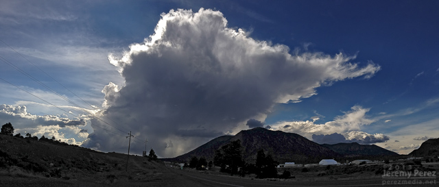
Panorama of a storm developing south of Flagstaff as seen near I-40 and 4th Street at 2:18 PM.
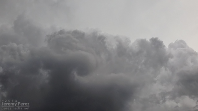
New development overhead a few minutes later was drawing in a bit of vorticity and sculpting a brief cinnamon bun into the cloud base.
July 3, 2013
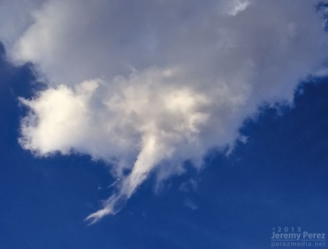
The base of a dying updraft over east Flagstaff tapers to a point.
The dwindling remnants of the eroding storm base reveals a slowly rotating spindle–not rapid enough to be a shear funnel.
July 4, 2013
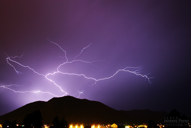
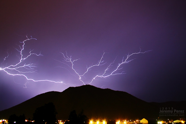
An active storm north of Mt. Elden puts on a beautiful show of ongoing anvil crawlers.
July 11, 2013
Pop-up convection develops west of Flagstaff as seen from Rt. 66 in east Flagstaff.
July 20, 2013
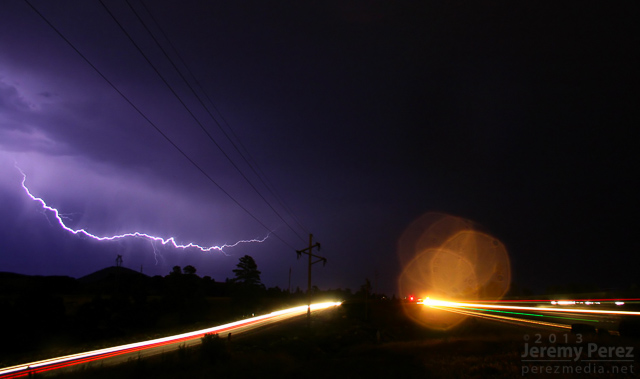
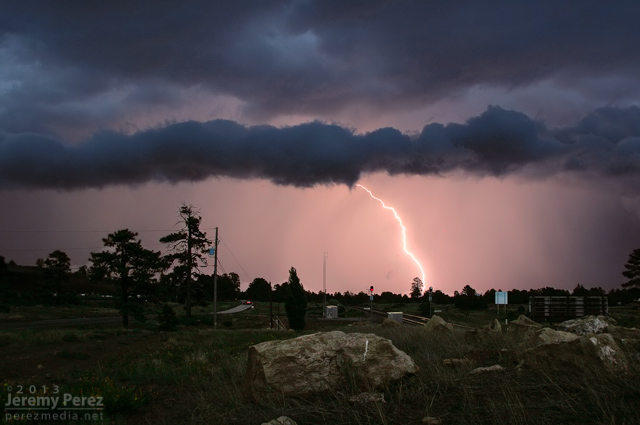
Lightning flickers behind a weak gust front east of Flagstaff as seen from Rt. 66.
July 23, 2013
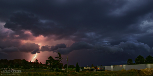
Inflow, chilled by heavy precipitation, creates a rugged lowering in the rain free base of this storm over Schultz Pass. As seen from 4th Street in central Flagstaff
August 23, 2013
Dry outflow pushes a growing wall of dust northward from Tucson, as Picacho Peak rises above the dust and desert floor. The photo was taken by my wife, Amanda, as we drove north on I-10 toward Phoenix.
August 26, 2013
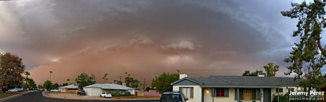
An ominous haboob blew into Phoenix, featuring a laminar updraft, intermittent shelf cloud and spectacular lightning after the gust front passed. This view is facing southeast as seen from near central Phoenix.
September 2, 2013
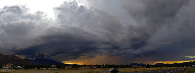
A beautifully lit and structured thunderstorm brews over the San Francisco Peaks as seen from Highway 89 in northeast Flagstaff.
September 7, 2013
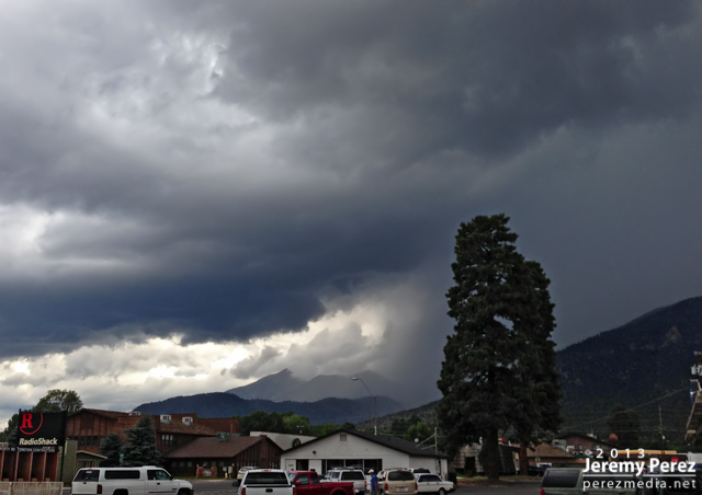
Looking south as a clump of northbound thunderstorms pushes a ragged shelf cloud into east Flagstaff. September 7, 2013. (Another iPhone panorama, so some of the seams are a bit jumpy.)
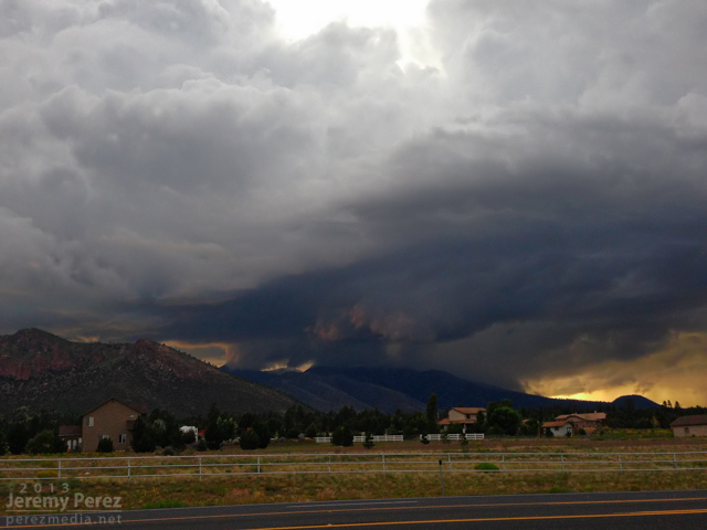
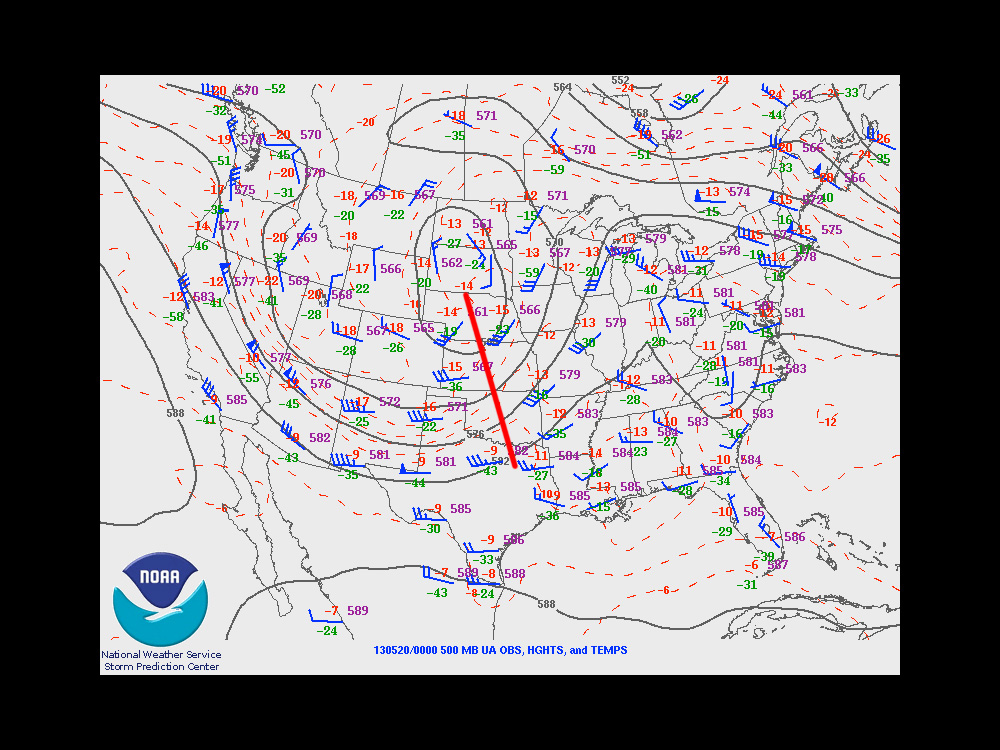
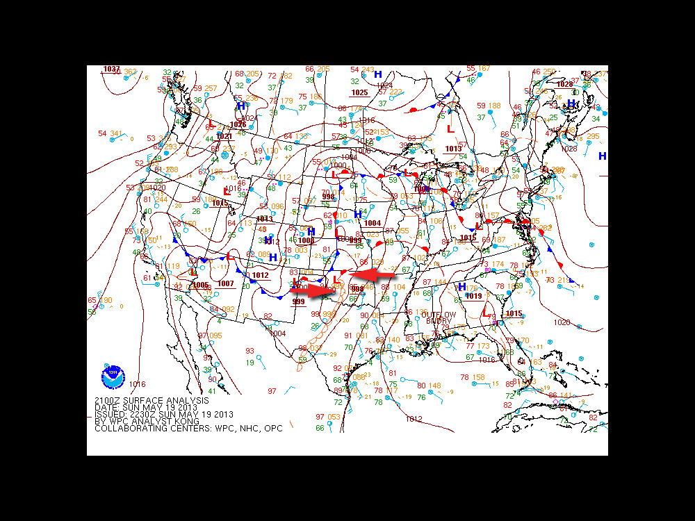
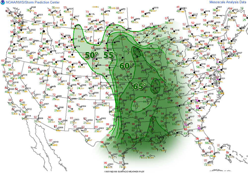
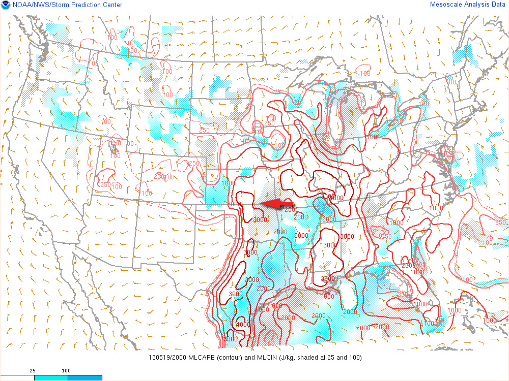
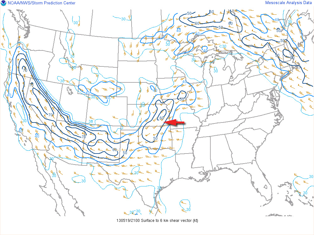
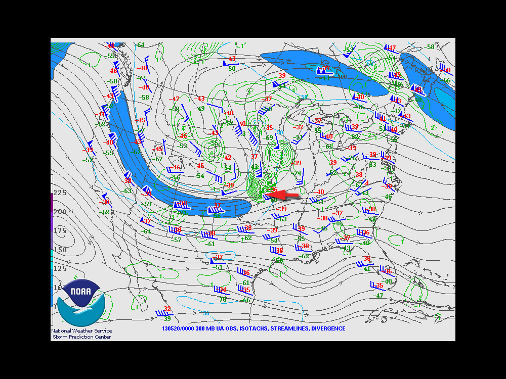
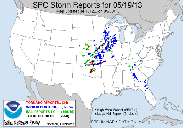
The trough that led to the amazing Rozel, Kansas tornadoes on May 18th, 2013 was positioned to support another round of severe weather on the 19th. Dew points were reaching into the upper 60s into eastern Kansas and Oklahoma. With steep mid-level lapse rates, mixed layer cape levels were heading over 3000 J/KG. Ample shear was in place to support supercells. The exit region of an advancing speed max ended up giving further support to strong, widespread convection over eastern Kansas.
An outflow boundary was positioned just south of the Oklahoma-Kansas border. With the advancing dryline, these two would help focus storm initiation and increased tornado potential along the outflow boundary.
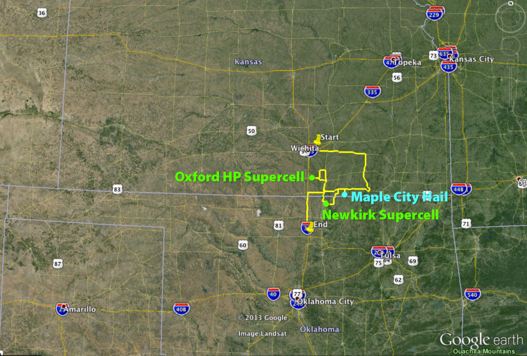
I chose to begin my chase further north in Kansas because I anticipated Oklahoma storms along the boundary would propagate into difficult chase territory and storms further south along the dryline would enter dense urban areas along the I-35 corridor.
Storms ended up erupting in two clumps: one area from east-central to south-central Kansas, and another pretty much right over the OKC metro area.
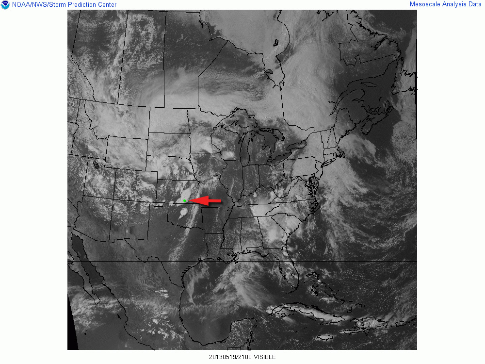
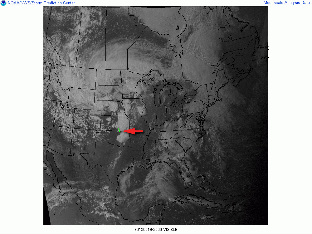
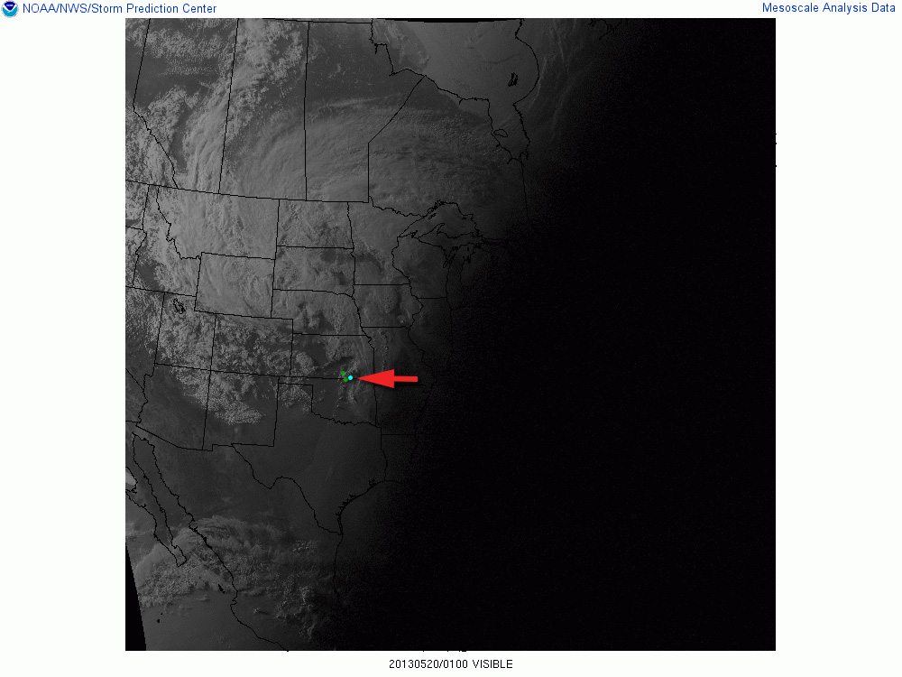
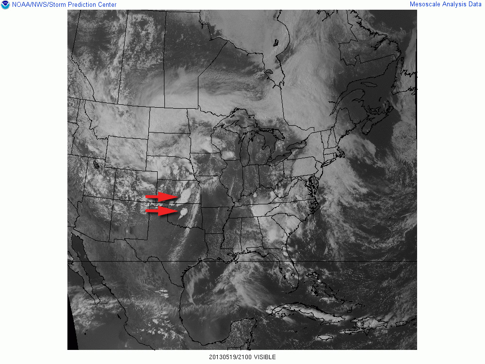
21Z Visible Satellite21Z/Oxford Storm23Z/Newkirk Storm01Z/Maple City Storm
Video documentary of the chase.Thematic spot to park and check data south of Moline, Kansas (1800Z)
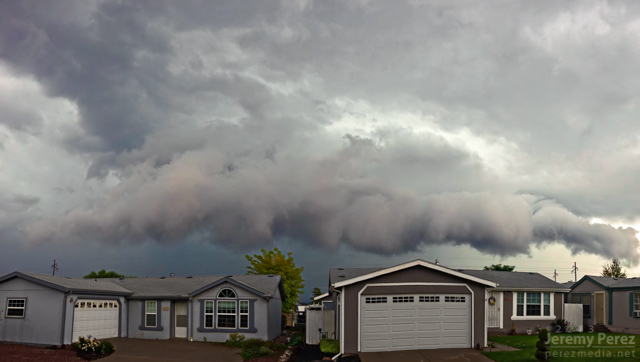
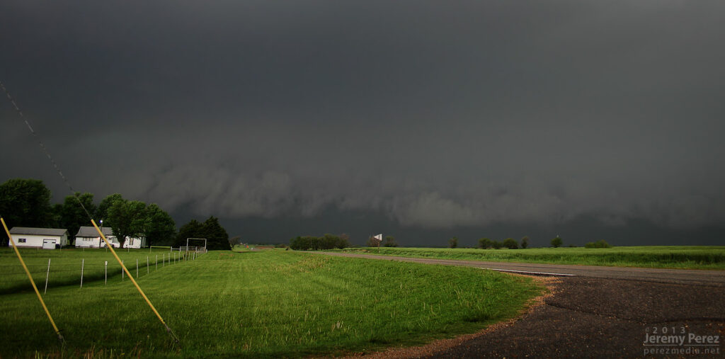
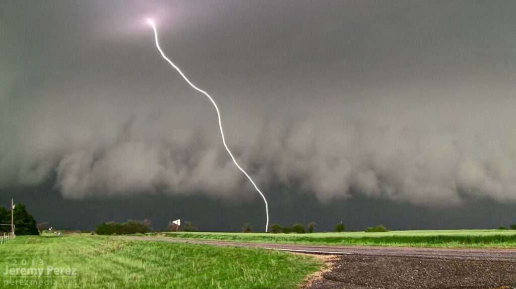
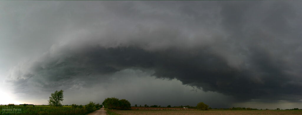
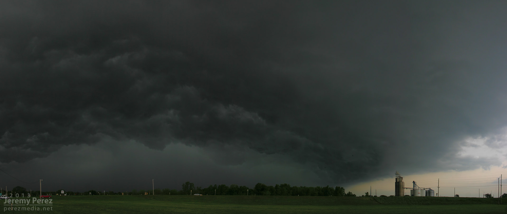
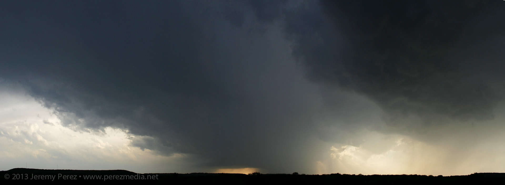
As storms matured, I made my way toward a cell approaching Oxford, Kansas. By the time I was positioned east of Oxford, the storm was HP and had a tornado warning. The look of the storm was incredibly menacing. The forward flank was lofting a ragged, low shelf that had the train-like appearance of an inflow tail as it led into the sealed notch between forward and rear flanks. Positive lightning strikes were landing just ahead of it and casting off fearsome canon-shots of thunder.
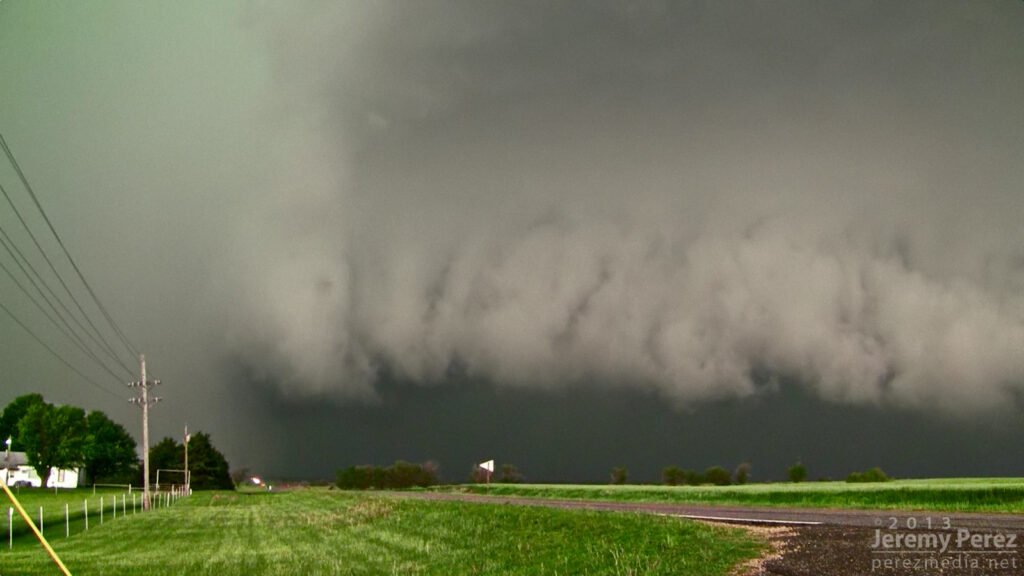
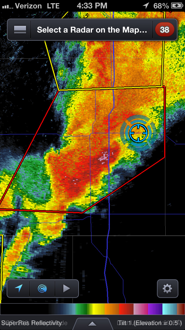
Reflectivity and position near Oxford, Kansas (2133Z)Approaching forward flank (2133Z)Positive charge lightning strikes ahead of the Oxford HP Supercell.The green rear flank rolls northeastward along the heavy forward flank of the Oxford HP Supercell.
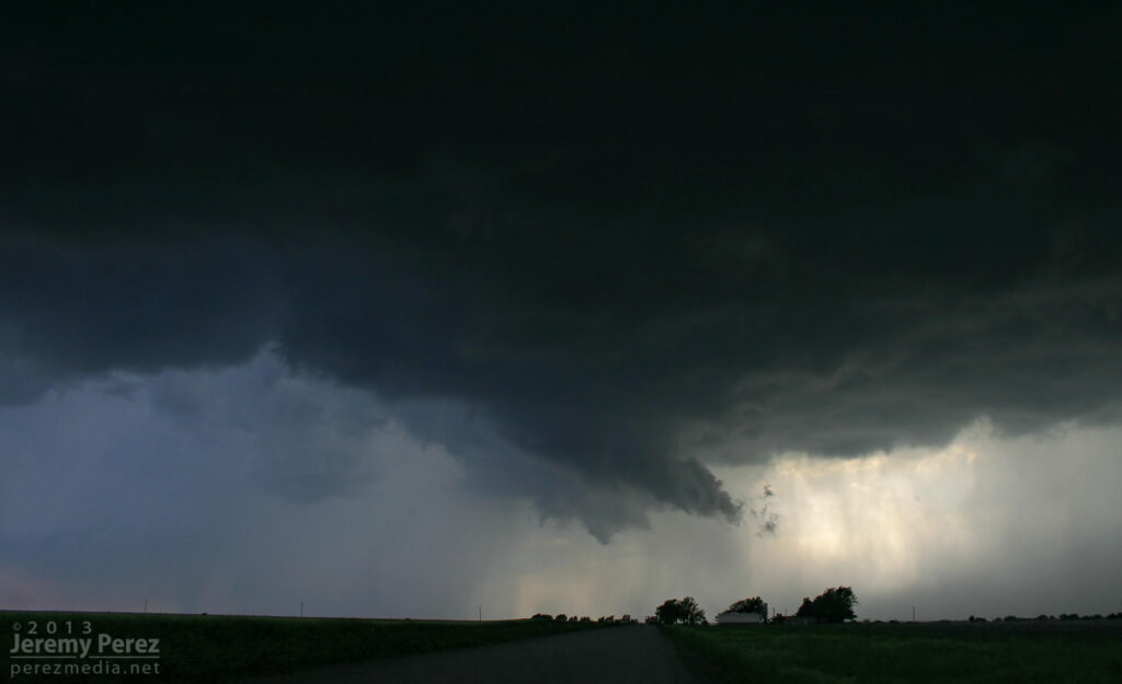
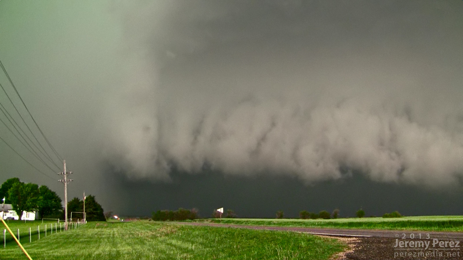
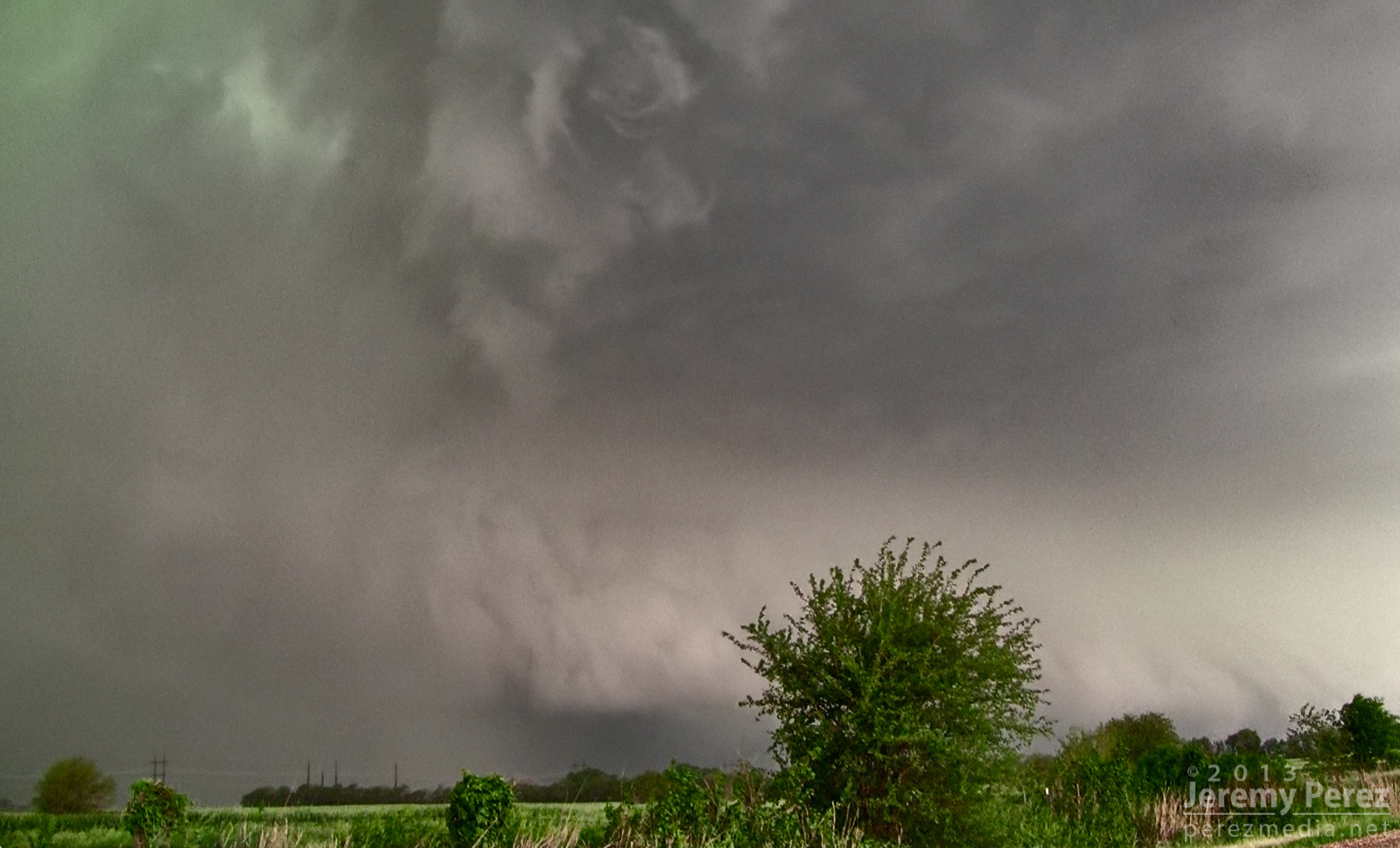
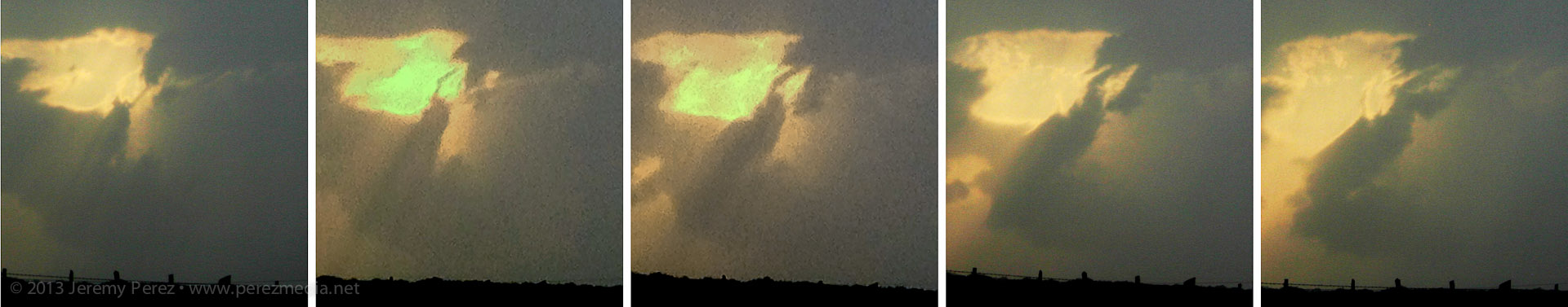
As the green RFD curtain approached, like it was rolling along the gears of the forward flank, I repositioned three miles further east. From this new spot, I witnessed the spectacle of rapid circulation developing in the rain free base just ahead of the FFD/RFD notch as a new RFD seemed to push out, trying to get ahead of the occlusion. The established RFD was moving in quick, so I had to abandon that spot and drive east to stay ahead. So I wasn’t in position to see the tornado that was reported 6 minutes later about 6 miles northeast of that spot.
Circulation developing in the rain free base just ahead of the Oxford HP Supercell.
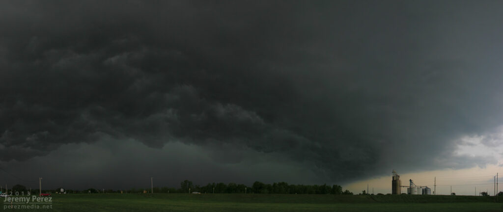
About that time, the Oxford storm started to congeal with others and form into a severe squall line. This convinced me to work my way southward to stay out of the mess and look for opportunities with any isolated storms on the tail end of the squall line. I had some pretty impressive views of the advancing line as I headed south.
Massive gust front on a congealing squall line from Winfield, Kansas (2158Z)Another gaping gust front as seen from 4 miles south of Arkansas City, Kansas (2242Z) A brief rope tornado was reported 1 mile north of Arkansas City about 17 minutes later.
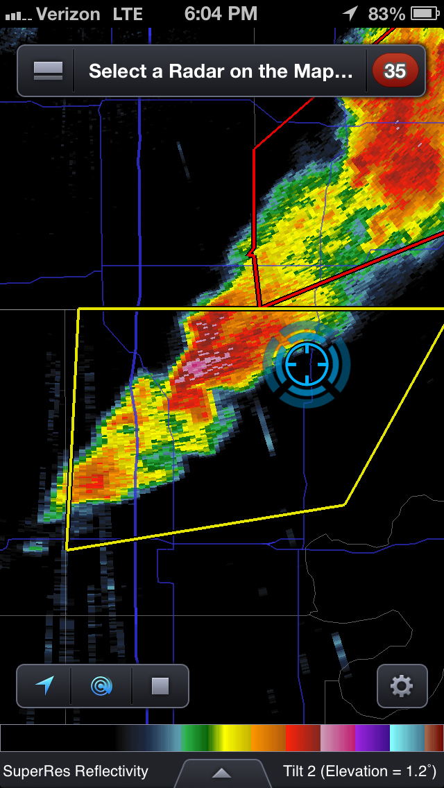
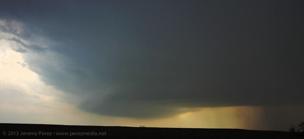
I eventually wound up on an isolated supercell near Newkirk, Oklahoma. I was able to hang out for a half hour in that spot and watch it approach. RFD was working its way into the base and encouraging a slender wall cloud to inhale scud, but it just wasn’t strengthening. I was also concerned about the quality of roads to my east, so I let it go. It picked up a tornado warning not long after.
Reflectivity and position near Newkirk, Oklahoma (2304Z)RFD cuts into the rain free base of a supercell 3 miles north of Newkirk, Oklahoma (2311Z)Scud rises into an anemic wall cloud on the Newkirk supercell (2313Z)RFD on the Newkirk supercell (2316Z)
Since new development still seemed likely, I decided to give the farm roads to the east a try. They were a lot better than I thought–pretty rocky actually–so I spent over an hour navigating north and east as I watched a very thin line of convection do pretty much nothing exciting stormwise, but did make for an excellent sunset display.
Tail end of a line of convection on the Kansas-Oklahoma border (2357Z)
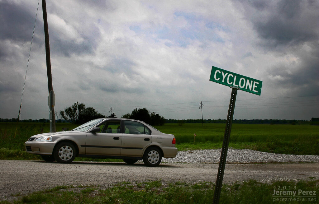
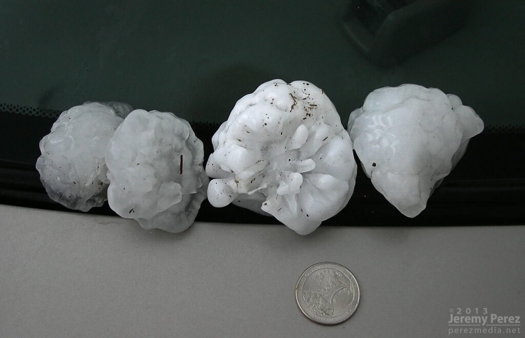
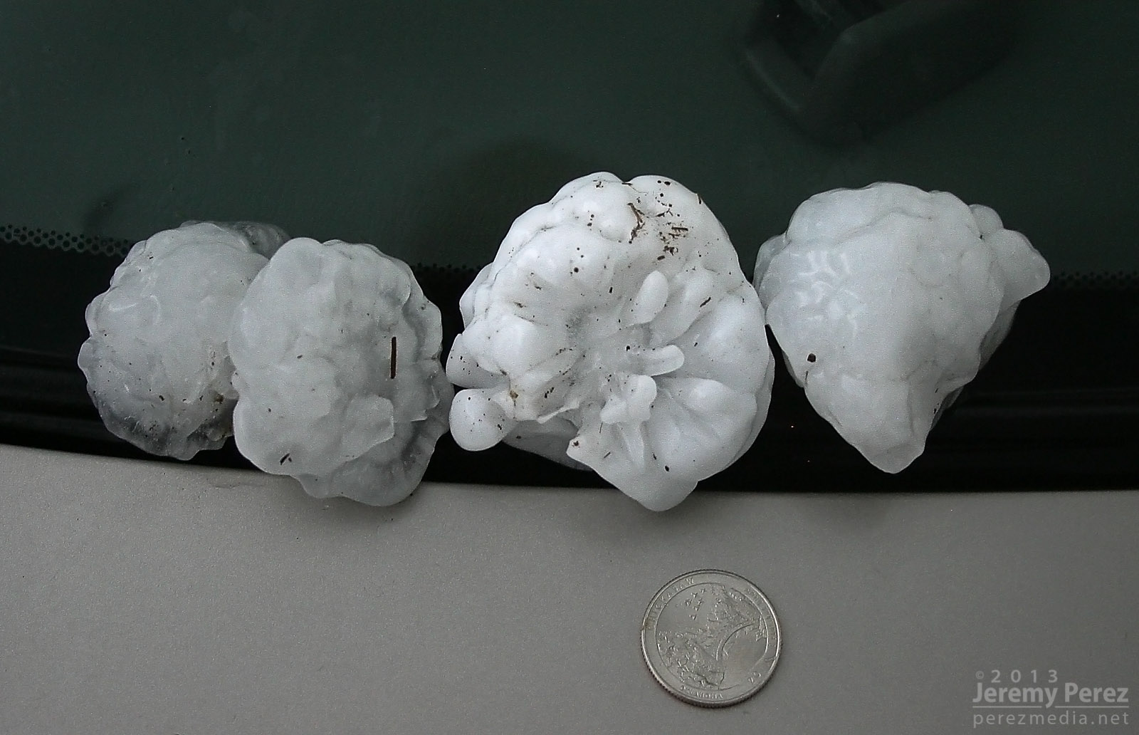
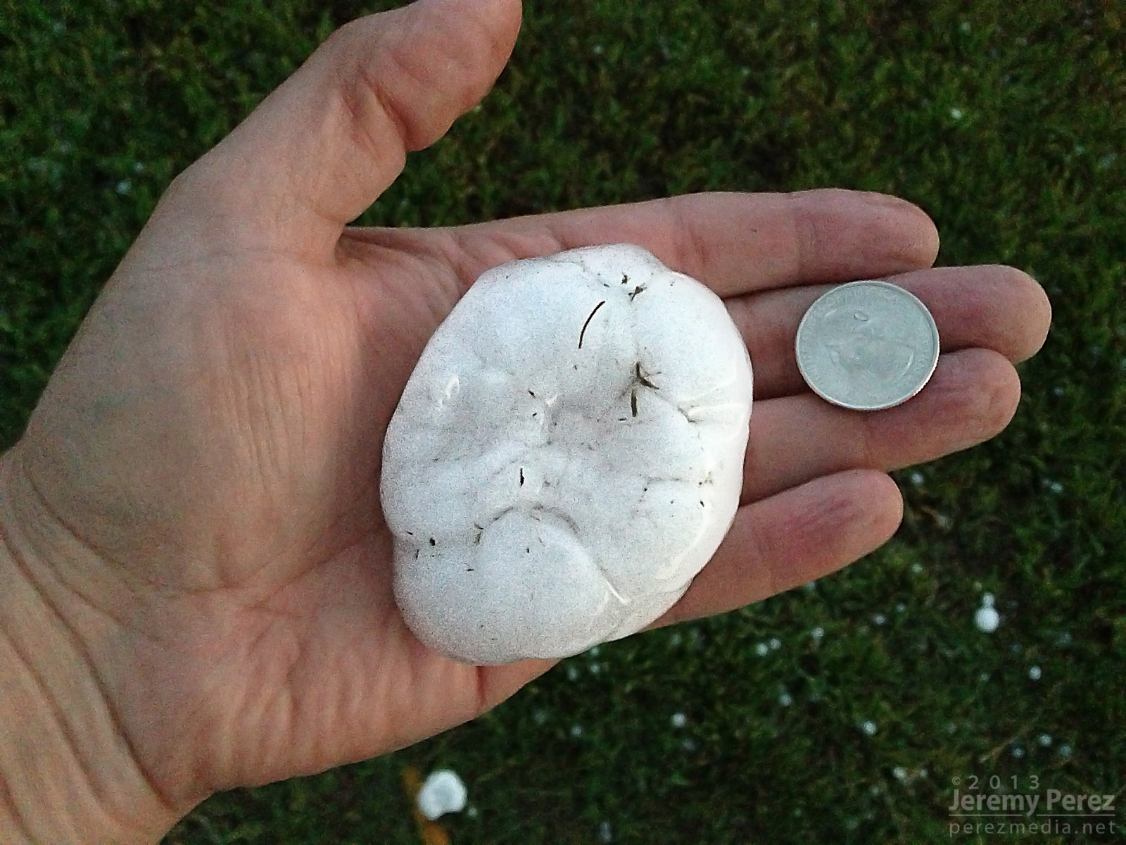
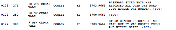
After finally getting back onto a paved road, back into Kansas, I noticed a severe-warned storm, moving up out of Oklahoma. I tried racing south to get ahead of it, but couldn’t manage it. After it passed, I did get to sift through its wake and picked up hail as large as 3 inches along the roadside about 7 miles east of Maple City, Kansas.
Collection of large hail (0130Z)Three inch hail near Maple City, Kansas (0130Z)Three inch hail near Maple City, Kansas (0130Z)My first contribution to an SPC storm report.
So, no tornadoes, but definitely some awesome sights on this chase. The dynamics near Oxford were unforgettable, and even though I missed seeing the tornado, I had an amazing perspective on that storm.
May 19, 2013 Chase MapSPC Storm Reports – May 19, 2013
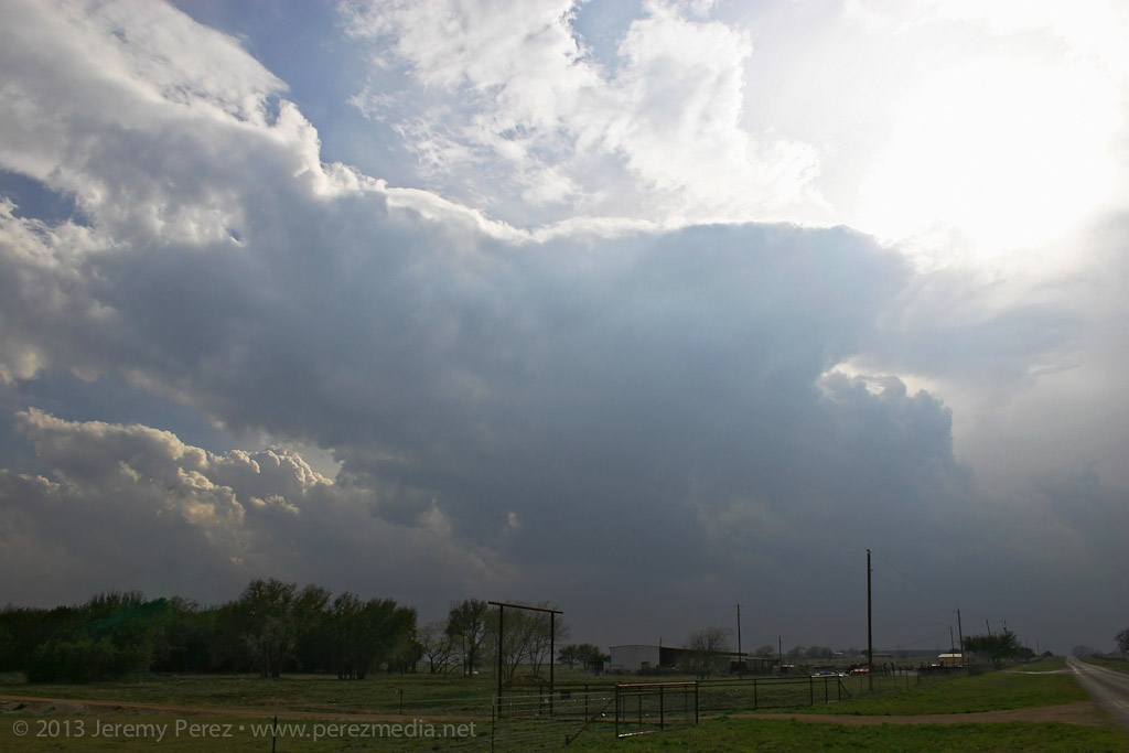
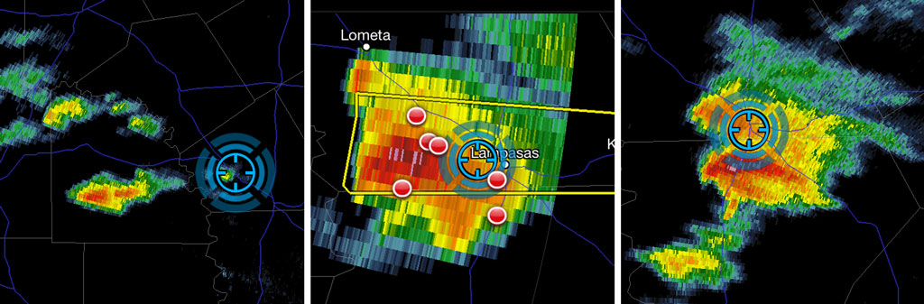
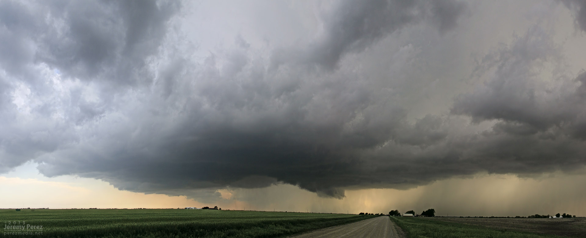
A forecast shortwave, 1000+ J/kg of CAPE, and directional shear supportive of supercells along a northwest-southeast boundary brought us to central Texas on Tuesday. We got a late start heading out of Elk City, but arrived near Lometa just in time to watch the first convection go up to the west of us.
Convection fires west of Lometa, Texas
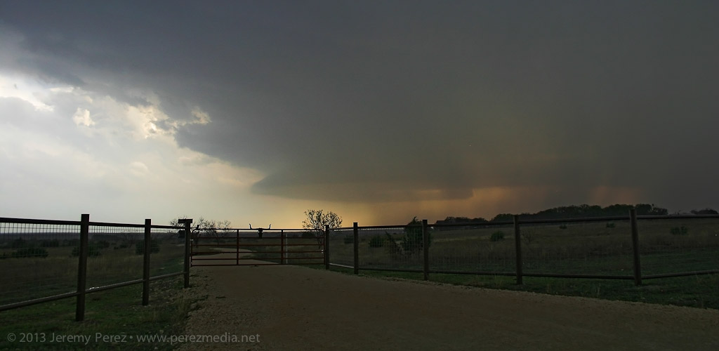
The lead cell was gaining strength, but still linear in appearance, and we positioned ourselves along US 183 thinking that it would cross the highway just to our west. The leading edge of the storm was hitting the boundary and getting demolished–pretty strikingly actually. I figured it was dying out, and we’d wait for another cell to try it’s hand. I gradually realized that the lead cell wasn’t shriveling up and dying, it was just dropping its wasted, linear, northern edge and mashing up its inflow on the boundary, taking root and gaining strength.
Trees and precipitation were obscuring the base. So we quickly re-positioned further southeast and noted a nice, bell-shaped base had formed with good separation from the forward flank.
Supercell gains strength southwest of Lometa, Texas
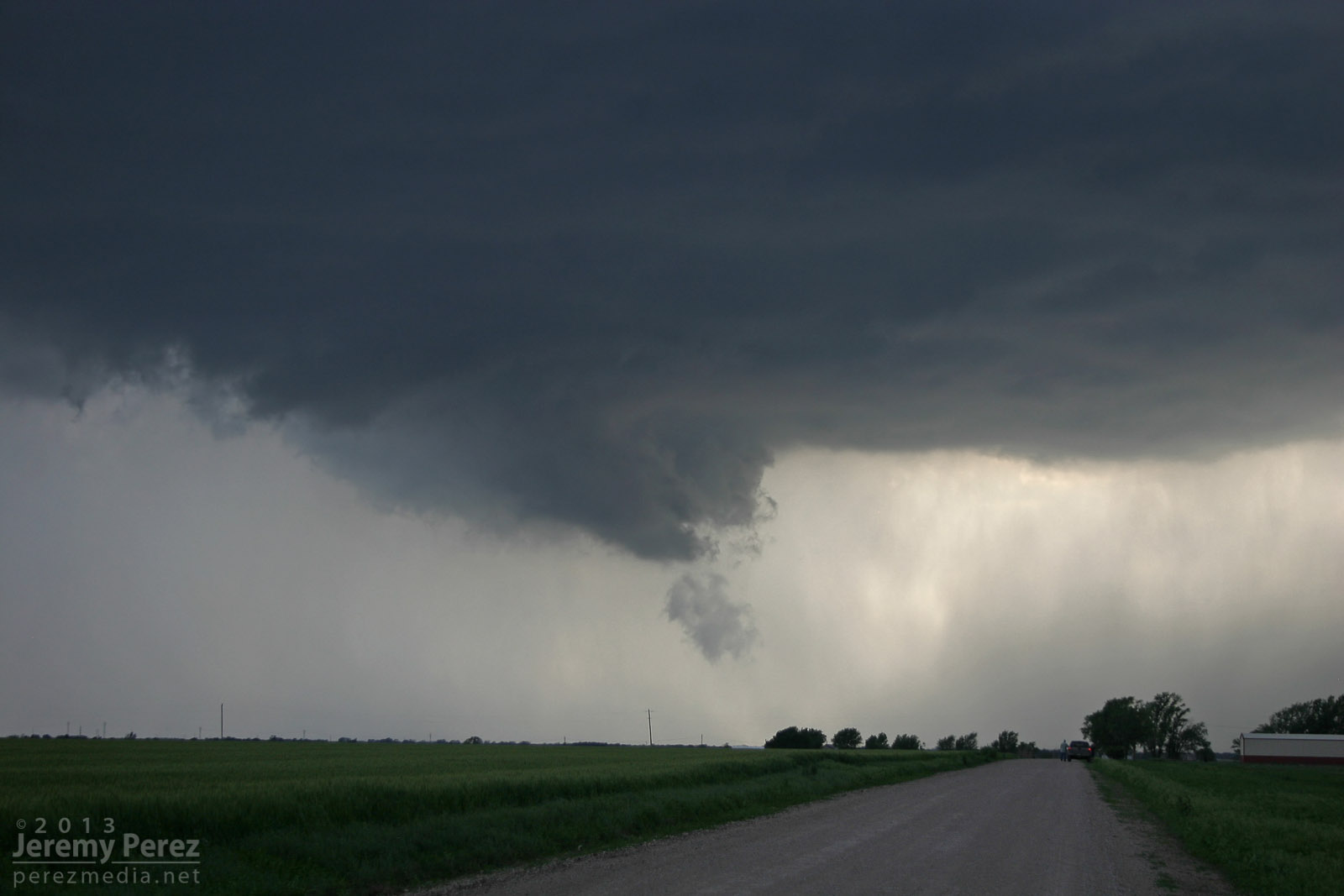
I was also realizing that the road network was going to make positioning a struggle. We made our way to Rt. 580 and headed west to get closer, when the base started looking pretty gnarly. This was my first time intercepting a RFB along the fringe of the forward flank so I was having trouble picking apart the silhouetted structures through the precipitation. Just as I was making out the inflow tail, RFD and tattered wall cloud, a multi-vortex funnel took shape like cheese pulling off the tip of a slice of pizza.
Tattered, complex funnel takes shape
The upper rope section was obvious, but it was attached to a heavier lower segment that seemed to be laminar in profile, so that might have been a chunky segment of the funnel. Hard to say for sure, unless someone closer has better shots with more dimension than mine.
Funnel sequence
Video of funnel (Frustrated that I forgot to set the video camera focus to infinity)
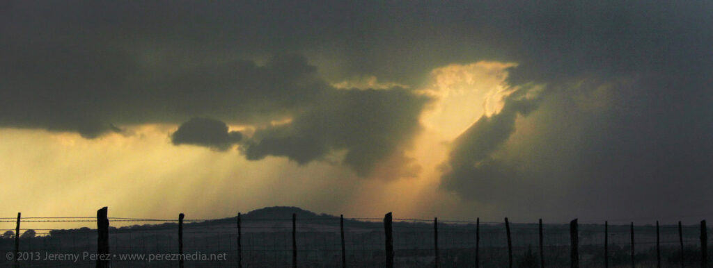
We snagged a few shots and some video before it dissipated. As we drove back to the east, a new meso was spinning up to our south. After this point, the cycling and meso hand-offs were pretty steady and extremely impressive to watch in action.
RFD gust front and shelf form under new meso south of Lometa, Texas
Keeping the rental car out of the hail on the sparse diagonal road network meant that we couldn’t get back ahead of the hopscotching cycle-fest. We almost raced ahead of the third new bell-shaped base, but had to turn back when the marbles started hitting. But not before getting an awesome glimpse from the vault as the inflow and condensation raced in along the leading edge of the base.
Reflectivity of the cell as it went from linear and appearing to die on the boundary (left) to nice supercell spitting out a funnel (center) to a cycling supercell that headed me off from getting back ahead of it (right).
It was a new positioning perspective and pretty exciting to be in that location, but also a bit frustrating with a car that I can’t afford to get pinged. This was also my first experience watching a storm get forced into intense cycling by a boundary. I’m hoping a few others got some good shots and from better locations than I had!
New rain free base forms near the horizon, south of Lometa, Texas
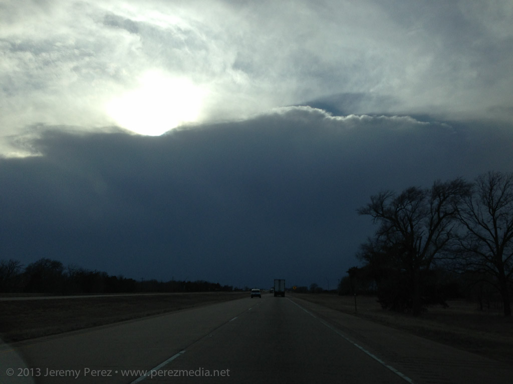
A shortwave crossing the Texas panhandle Sunday afternoon helped light up a line of elevated convection. We headed out from Elk City to hang out under the gust front and get some hopefully nice twilight photos. The line was severe-warned for a while with strong outflow gusts producing several reports in the western Panhandle. I wasn’t expecting much more than a few photo opportunities.
Driving west on I-40 toward the advancing line
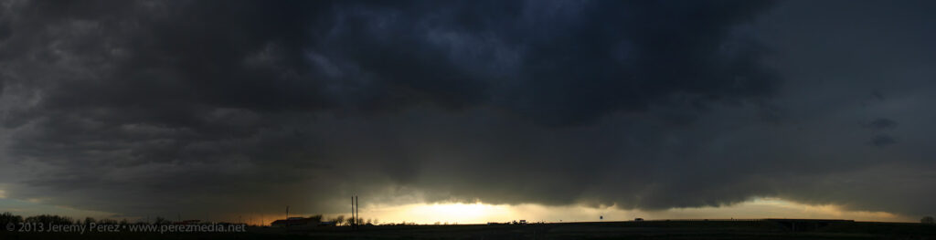
After spending some time in the cool outflow, I noticed a rain-free base form east of us on the leading edge of the line. I figured it would look nice as the sun got further down and lit it up, so we headed east on I-40 to get ahead of it.
About the time we were getting near the outflow interface, we were surprised to see an amputated, chaotically spinning, gray rope of condensation materialize over the highway in front of us. It winked in and out, and then got a bit more persistent as it drifted from south to north. I didn’t have perspective on the cloud base overhead to see if this might have been a fractured piece of a landspout, or if it was a gustnado. I’m interested on any thoughts about whether gustnadoes produce condensation funnels.
Animation of condensation funnel crossing I-40 (facing east)
I wasn’t ready with either camera, so this 5 animation is a pretty crummy attempt to show the feature drifting across the highway. (What this doesn’t show is the churning action going on–pretty much like a remnant section of a rope-out.)
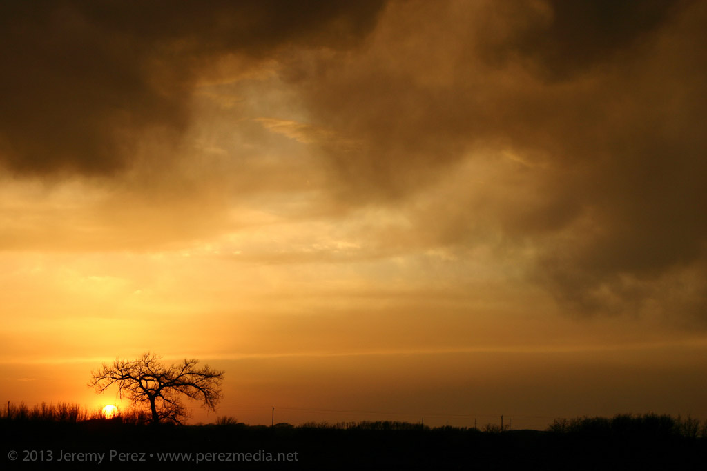
Apart from that, the dwindling convection led to some nice sunset views.


