Tag: forecasting

  • 22 March 2018 | Lenticular Cloud Forecasting

    22 March 2018 | Lenticular Cloud Forecasting

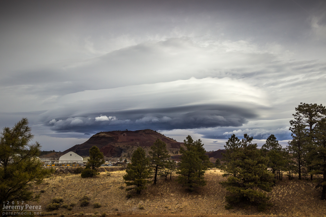
    This morning, I got treated to this tubular breadstick-of-a-lenticular-cloud. Almost always seems I’m in a hurry to get somewhere when I spot these. I had to stop for at least a few minutes to grab some shots.

    It finally got me thinking how I could attempt to forecast these in advance. They tend to form downwind of the San Franciso Peaks in advance of an approaching trough…but not reliably. Seems to me that it probably isn’t as straightforward as ‘moist, stable air flowing over a mountain’. I pulled up this morning’s sounding and plotted soundings for a couple previous days when I had photographed them.

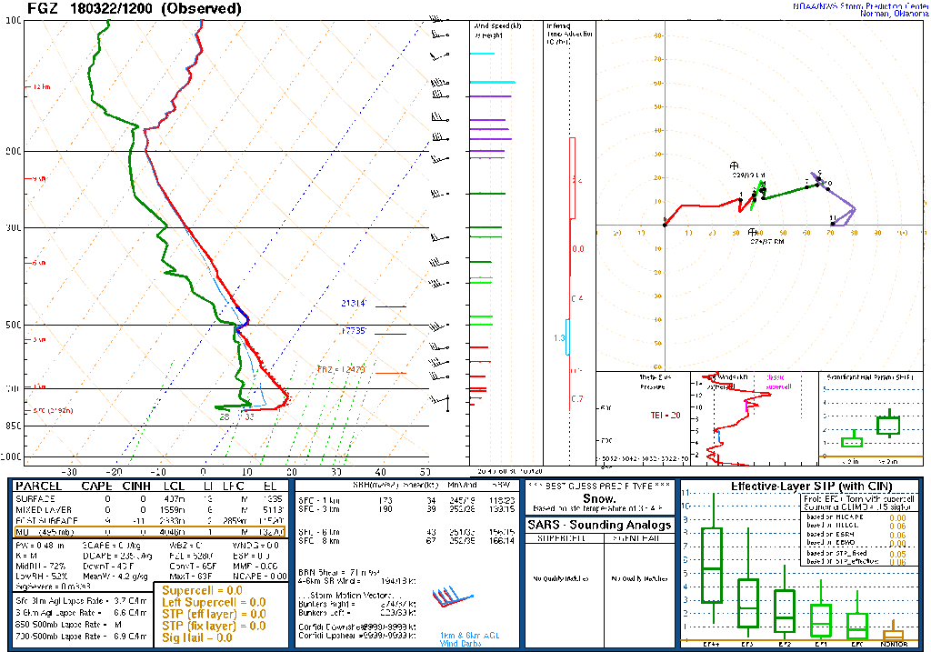
    What stood out to me so far were some common traits:

    • Elevated terrain feature – to generate eddies
    • Upper level winds around 40-50 kts with 15-25kts near terrain feature – sufficient wind speed to convert horizontal terrain interaction into sufficient vertical motion. The San Francisco Peaks reach to about the 650mb level, so I’d watch for winds beginning to pick up around that level.
    • Roughly uniderectional upper winds – to support laminar flow
    • Stable air mass – to avoid mixing and further support laminar flow
    • Dew points within 5°C of saturation at one more points in the upper air mass – to allow air to condense when it is lifted from terrain eddies
    • Dry air in lower levels – to allow clear visibility to lenticular cloud features
    • [edit 31 March 2018: a couple additional bullets added below, courtesy of feedback from John Sirlin]
    • Shallow inversion above mountain – seems I did see this on a couple soundings, so I’ll be watching for that too.
    • Orientation of flow to terrain feature – For terrain that is elongated, look for greater likelihood when flow is perpendicular to this feature. I haven’t watched for this with the San Francisco Peaks since they’re fairly symmetrical, but should be something evident with flow lofting over the Mogollon Rim.

    I want to play with those options when I get the chance now, to see how repeatable I can get with seeing that combo of elements leading to lenticular clouds. Is there a limit to how slow flow can be at the terrain feature? Does flow at 650mb even matter for the Peaks or does it still get captured if 500mb flow is strong while winds below are weak? If upper level wind direction varies by more than say 30 degrees, does it wreck the effect? What if there is a tiny bit of elevated instability – at what point does it start to interfere? How far from saturation can dew points be and still be expected to condense into lenticular clouds?

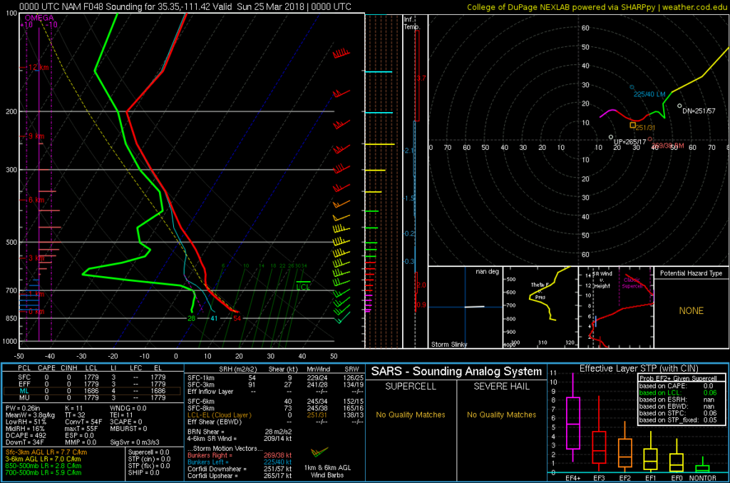
    With those options in mind, I pulled a NAM forecast sounding for this Saturday afternoon. If that forecast pans out, it could make for some lenticular action that afternoon with perhaps a cloud cap just above the mountaintop and possibly a high altitude wave off to the east-northeast. I’ll keep an eye out and see how wrong I am.

    I’ll update with how that goes

  • 18 May 2014 | Virtual Storm Chase

    18 May 2014 | Virtual Storm Chase

    So much for Virtual Chases. I’m planning to head out to the plains for a few days to try chasing some marginal setups. Not sure if I’ll be able to post a forecast ahead of each day, but I’ll start with my first opportunity this Sunday.

    Target: Northeast Wyoming

    With all the frustrations of a flimsy severe weather pattern setting in for the latter half of May, it still looks like there will be isolated/conditional opportunities in the northern plains and elsewhere as a trough moves onshore this weekend and starts cutting off in the southwest early in the week.

    For Sunday afternoon/evening, per guidance from NAM, I’m looking at a target in northeastern Wyoming as 40-50 kts of southwest H5 flow moves in over an area of low to mid 50 dew points advects around a consolidating surface low in that target area. A narrow, meridional zone of 1500-2000 j/kg CAPE will develop along the eastern Wyoming border with the CAP weak or open by mid to late afternoon in the northern portion of this ribbon. Today’s 12Z NAM forecasts a focal point for convection in this area by 00Z with that area potentially ingesting 100-150 m2/s2 0-1km SRH. Mixed layer LCLs are in the 1500 meter range and heighten quickly the further south you go.

    If this plays out well, I might hope to see an isolated, high-based supercell drifting slowly into South Dakota. I have no expectations of anything tornadic with this setup. And if today’s 06Z GFS has its way, then I can expect a bust with maybe some elevated showers in South Dakota (GFS keeps surface moisture about a hundred miles further east under stronger capping). 00Z ECMWF agrees better with NAM on placement of moisture and location of precipitation, so I hope that agreement favors my focus on NAM.

    This will be my first 2014 chase day during a week of very iffy conditions. I’m definitely concerned that I’m setting myself up for a series of busts, but also excited to take on the challenge.

  • 14 May 2014 | Virtual Storm Chase

    14 May 2014 | Virtual Storm Chase

    Chase Target: Zanesville, Ohio

    I’m relying on guidance from NAM for this forecast and have run out of time to compare with GFS.

    A surface low will be consolidating over western kentucky as afternoon progresses. A warm front will be established northeast of the low through southern Indiana, and northern Ohio. A cold front will nudge into western Kentucky/Tennessee and eastern Mississippi. Mid 60 dew points will advect into the warm sector. CAPE values of 1500 j/kg reside from central Kentucky northeastward across southeastern half of Ohio and western Pennsylvania while a pocket of 2000+ j/kg resides over southern Ohio during the afternoon.

    Mid level jet placing 40-50 kts of bulk shear over boundaries with enough extending over the warm side to affect convection. Strong 0-1 km SRH resides mainly north of the boundaries, but stronger pockets develop over western Kentucky during early afternoon, and 100+ m2/s2 over southeastern Ohio toward 00Z. Convection is forecast to be ongoing and messy throughout the day, so it’s difficult to for me to anticipate how that plays out in this area. My target is in southeast Ohio where 0-1km EHI rises over 1.5 by 00Z and the lid strength index points to wide openings for surface based storms in the area.

    Results

    Nearest Tornado Report: 94 Miles West-southwest
    Nearest Severe Report: 3 Miles Southeast [Hail: 1.5 inch]

  • 11 May 2014 | Virtual Storm Chase

    11 May 2014 | Virtual Storm Chase

    Chase Target: Ashland, Nebraska

    A trough over the rockies places 50kt H5 flow from the Texas/Oklahoma Panhandles through Kansas, Nebraska and Iowa by midday. The trough tightens over the afternoon, weakening flow across Iowa to just the extreme southwest part of the state.

    A surface low over western Kansas drapes a sharp dryline southward across far east border of the Texas Panhandle and southward from there. At midday, a cold front lines up from the central Kansas/Nebraska border through southwest Iowa and then a warm front up to northeast Iowa. By 00Z, the boundaries have advanced across northeast Nebraska and northern Iowa. East and south of the dryline/cold front/warm front, CAPE values reach or exceed 3000 j/kg by 21Z. LCLs will be rising throughout the warm sector throughout the day, but the southeast Nebraska and southern Iowa have best opportunity to remain at or below 1000 m through 00Z. After that, they lower to 500-750 m across Iowa.

    0-1km SRH gets over 100 m2/s2 on the warm side of the boundary, and spiking over 300 m2/s2 immediately on the other side. Hodographs along the warm front have huge, open, clockwise hodographs. Pretty scary actually. Southeast Nebraska at 21Z shows 0-1km EHI over 3 while Iowa waits until 00Z to reach that level. NAM convective forecast puts discrete cells and then ongoing convection in southeast Nebraska as well.

    Results

    Nearest Tornado Report: 10.9 Miles Northwest
    Nearest Severe Report: 9 Miles West [Wind: 60 MPH]

    A monster supercell erupted in south-central Nebraska and tracked east-northeast along the warm front north of Lincoln, and then north of my target of Ashland before moving into Omaha. It was a long track tornado producer, with the closest tornado report being 10.9 miles northwest of Ashland. A scattering of other tornado reports came from far southeast and far northeast Iowa/far southeast South Dakota, as well as a few from a dryline storm in central Kansas.

  • 10 May 2014 | Virtual Storm Chase

    10 May 2014 | Virtual Storm Chase

    Chase Target: Odessa, Missouri

    At 21Z a surface trough will stretch from North Dakota to northeast Kansas, migrating slowly southeast. A cold front will drape from the Nebraska/Iowa border, across east Kansas and into northwest Oklahoma where it transitions to a dryline southward across west Texas. Mid to possibly upper 60 dewpoints will be pushing northward into northern Missouri on 15-20 kt surface winds. As convection fires from 18Z-21Z, MLCAPE values could reach 3000 j/kg east of the front, with NAM aggressively plotting 4000 j/kg in west-central Missouri.

    Mid/upper level support takes the form of only slightly amplified flow with pockets of 40 kts at 500 mb across the central plains and into the midwest. The warm sector appears to get its best support across the northeastern three-fourths of Missouri with 50 knots of bulk shear over northwest and north central parts of the state. 0-1km SRH reaches 150 m2/s2 over the northwest quadrant of Missouri as well by 00Z.

    NAM forecasts convection firing in this better zone by 21Z with open, clockwise forecast hodographs showing up in both NAM and GFS. Lid Strength Index opens a brief opportunity for surface based storms in the 21Z time frame in this northwest Missouri as well, so placing my target at Odessa, east of Kansas City.

    Results

    Nearest Tornado Report: 16 Miles North-northeast
    Nearest Severe Report: Same

    Numerous severe storms erupted along the cold front and dryline around 20Z with a few supercells turning right and strengthening. The one that passed just north of Odessa generated a few tornado reports—the nearest 16 miles to the north-northeast.

  • 9 May 2014 | Virtual Storm Chase

    9 May 2014 | Virtual Storm Chase

    Chase Target: Fredericktown, Missouri

    I didn’t have a lot of time to prepare this. I targeted a location east of the cold front in southeast Missouri where the H5 speed max would provide bulk shear in the 40-50kt range between 21Z-03Z. NAM forecasts dew points in the mid 60s in southwest Missouri with CAPE reaching 2000 j/kg. 0-1 km SRH is not good, reaching maybe into 100 m2/s2 after 00Z, so I don’t see more than a very odd chance at tornado potential. NAM forecasts better parameters and reflectivity further north than GFS, so I tried to split the difference between them.

    Results

    Nearest Tornado Report: None Reported
    Nearest Severe Report: 16 Miles North-northwest [Hail: 1 inch] || 25 Miles Northeast [Wind: Roof off house]

    Insolation had an early start in my target area, which helped several severe warned and two tornado warned storms pass near Fredericktown. A wind report 35 miles south had this to say:

    3 S GREENVILLE Wind Report
    County, State: WAYNE, MO
  (marker location is approximate)

    Lat.: 37.08, Lon.: -90.45
    
Time: 2014-05-09 20:00
    UTC
Wind Speed: Unknown
    TREE LIMBS DOWN AND DAMAGE TO CAMPER AWNINGS AT THE OLD GREENVILLE CAMPGROUND. UNCONFIRMED REPORT OF FUNNEL CLOUD ASSOCIATED WITH DAMAGE. DAMAGE PATH ESTIMATED AROUND O (PAH)

  • 7 May 2014 | Virtual Storm Chase

    7 May 2014 | Virtual Storm Chase

    Chase Target: Davidson, Oklahoma

    Looking at the southern portion of this setup: it features a fairly neutral-tilt trough over western US with 50-60kt 500 Mb speed max edging eastward over the Panhandles/western Oklahoma/northwest Texas/southwest Kansas. The 18Z NAM forecasts 40-50kt bulk shear over northwest texas to northwest Oklahoma by 00Z and increasing thereafter. The 18Z GFS spreads that out more, but pushes it further northwest. An elongated surface trough is forecast to tighten up from northeast Colorado to eastern Nebraska with a dryline retreating westward during the afternoon/evening and ending up at 00Z from western Iowa through central Kansas, southwest Oklahoma and south from there into Texas with mid 60 dewpoints in place. CAPE values range from 2000 (GFS) to 3000 (NAM) j/kg east of the dryline by mid-late afternoon. By 00Z, GFS breaks out convection north of the Red River while NAM plants south of the Red River. Both models/areas feature widening hodographs toward and after sunset. NAM features EHI building from 1.0-3.0 around and south of Vernon Texas from 00Z-03Z with 0-1km SRH approaching 300 m2/s2 by 03Z. LCLs start to drop toward 1,000 meters from 00Z-03Z as well.

    [Update 1515Z:] Latest NAM, HRRR and RAP reflectivity forecasts are showing some differences in where convection will initiate and strengthen. 06Z and 12Z NAM fires things up right over my target area. RAP and 12Z HRRR however are lighting up further east at mid afternoon with HRRR firing a weaker second round over my target area a couple hours later. It seems like HRRR is anticipating the dryline sitting further east around 21Z when convection initiates, and then the dryline starts retreating right after that. I’m interested to see if SPC nudges the risk area eastward or not. The difference is about 50 miles, so if I were there, I’d be pleased to just sit in my current location, watch the dryline mark itself out, and then adjust if needed as cumulus gets more agitated.

    Results

    Nearest Tornado Report: 30 Miles Southeast
    Nearest Severe Report: 18 Miles East-northeast [1.5 Inch Hail]

    Storms that fired near southwest Oklahoma did fairly well toward 00Z with a tornado-warned cell crossing the Red River near my target area. Apparently there was a spotter report of a tornado near Burkburnett, but I haven’t seen it posted to SPC storm reports as of 0500Z.

    [Update May 8, 2014:] SPC is still updating storm reports, and have now plotted two new tornado reports: 30 miles southeast of my target, near Burkburnett, and 40 miles north-northeast, in the Wichita Mountain Wildlife Refuge.

  • 30 April 2014 | Virtual Storm Chase

    30 April 2014 | Virtual Storm Chase

    Chase Target: Newington, Georgia

    A surface low is forecast to elongate over Wisconsin and Ohio with a cold front draping through eastern Tennessee through the Florida panhandle and migrating slowly eastward. The upper low will be over Iowa with 70 kt 500 mb flow flow aligned over cold front with 35-40 kts extending out over the warm sector to the east leading to 35-40 kts of bulk shear in that area.

    Dewpoints from 65-70 will be in place from Florida through east Virginia. NAM and GFS paint different pictures of early convection/cloud cover/surface heating and subsequent CAPE values. If GFS pans out, 2000 j/kg CAPE will build from the Florida panhandle through central Georgia and South Carolina. If NAM pans out, some smaller pockets of 2000 j/kg will build along coastal Georgia/far south South Carolina. RAP so far looks like it’s splitting the difference between NAM and GFS on the situation.

    00Z NAM paints large pockets of 100-150 m2/s2 0-1km SRH through central Georgia and more broadly north of there, reaching over 200 m2/s2 from western North Carolina and Virginia. Timing of the convection is variable across the models, could take the form discrete storms, a line, a broken line, a boggy mess. The best compromise of moderate CAPE, SRH, and bulk shear seems to be at the Georgia/South Carolina border close to the coast.

    [Edit 1500Z:] Oh man…there goes my forecast area again, immersed in another MCS outflow & anvil festival. I may pull the plug on the chase case opp in the next hour.

    [Edit 1530Z:] Alright, I’m going to leave my target in place and let the chips fall where they may. Current satellite trend looks like anvil cover is thinning gradually, and radar appears to show the MCS being progressive, instead of squatting over one area like yesterday. Probably wishful thinking, but maybe there will be enough clearing for the airmass to recover. Or maybe I’ll see a random wind report.

    Results:

    Nearest Tornado Report: None
    Nearest Severe Report: 198 Miles Northeast [Wind Report]

    MCS Forecast Botch #2. Between today, yesterday, and my 2011 experience, this is definitely a weakness for me. What do I look for to say, yeah—the models aren’t picking up that today’s storms are going to get comfy and build a cold, wet nest all over tomorrow’s boundary layer? It doesn’t just put a hole in the setup where you can drive a couple hours and be out of it—the stable blanket lays over multiple states, and may just be a situation of deciding to start the long drive home the night before if you know it’s going to pan out that way. Research.

  • 29 April 2014 | Virtual Storm Chase

    29 April 2014 | Virtual Storm Chase

    Chase Target: Paulding, Mississippi

    Upper level low over easter Iowa with 70-80 kts of flow over Louisiana/Mississippi/Alabama. Surface low is stacked right under its upper level partner. A cold front wraps through western Kentucky/Tennessee, northwest Mississippi and northern Louisiana at 18Z and pushing slowly southeastward during the afternoon. Upper 60 to 70 degree dew points are in place early with surface winds veered more strongly the further north you go approaching the front. CAPE values over the southeastern two-thirds of Mississippi, boot of Louisiana, and west-central Alabama start off over 3000 j/kg at 18Z and get eaten away by convection as the day goes on. Bulk shear over this strong instability is over 60 knots early on but relinquishes its hold over most of southern Alabama by late afternoon. 0-1km SRH is in the 150 m^2/s^2 over the southern third and a central pocket of Mississippi and floats ahead of developing convection. EHI is pegged over 3 in those central and southern pockets of Mississippi at 18Z when convection is heating up. Convective models show an early start to storms with supercells forming by midday in Mississippi and moving into Alabama during the afternoon. This is still early, messy convection and difficult to untangle options.

    [Edit/Update 2230Z:] An ongoing MCS from yesterday’s storms on the gulf coast has not given up all day. Outflow and massive anvil cirrus has kept the southern two-thirds of Alabama and southeastern quadrant of Mississippi from heating up and reaching forecast instability. Storms have been trying to get going ahead of the cold front across Mississippi—much later than anticipated—but struggling much of the past couple hours. One storm about 70 miles southeast of my target area has picked up a tornado warning and is moving roughly eastward. It’s pretty strung out, the velocity couplets look anemic to my eye, and it’s not moving into better instability. So hard to say if it will last long.

    Results:

    Nearest Tornado Report: 632 Miles East-northeast …ehhh, probably ridiculous I’m tallying that…
    Nearest Severe Report: 64 Miles West-southwest [1 Inch Hail]

    It’s amazing how soundly the non-stop MCS on the gulf coast turned the severe risk around for the region. Reminds me of May 11, 2011, when I woke up from the roach motel in Pratt, Kansas, on theoretically the strongest setup of the trip, to find an unexpected MCS and inbound anvils from Texas completely erasing the storm environment. It sure is a lot better to tank a forecast from home than 800 miles out! (The tornado-warned cell that was approaching Paulding did drop some meager hail with a couple reports 64+ miles out.) It’s a great relief all around that communities in the south got a reprieve from the last couple days of ruthless weather.

  • 28 April 2014 | Virtual Storm Chase

    28 April 2014 | Virtual Storm Chase

    Chase Target: Kilmichael, Mississippi

    The closed upper low over eastern Kansas/Nebraska won’t have moved much in 24 hours. The surface low is pretty closely stacked at the Nebraska/Iowa border with a cold front/dryline arcing along eastern Missouri, Arkansas and Louisiana. Organized convection is forecast (per NAM) to start firing up around 15Z along the western Mississippi border. CAPE grows toward 2000+ j/kg ahead of this convection, better the further south you go, but capping appears to be a challenge and may prevent surface based convection. Upper air support is in good shape, at 60 kts early on. There is no standout location to me, other than staying north of heavier capping, but still south enough enough to find better instability. Forecast reflectivity and precipitation is a mess and difficult to interpret. SRH gets better as the day goes on, so trying to position a bit further east to give the line of storms time to take advantage of that. Once again, not an area i would chase, and definitely a setup I’m even less comfortable forecasting a chase target.

    [Edit/Update 1745Z:] This morning, HRRR was forecasting 2 rounds of convection moving through Mississippi at 18Z and 23Z. Watching radar at 1730Z that first round is definitely firing up. There has been clearing ahead of it and surface heating underway. In particular, a serious looking cell erupting near Indianola. If I were chasing in this crazy terrain, I would be heading north to meet it near Grenada. And then there’s round to toward late afternoon. Hoping people are considering locations of shelters and listening to weather alert radio or TV!

    [Edit/Update 1900Z:] A string of several tornado warned supercells have formed from north-central through west central Mississippi. Really hazardous situation. With 40-50 mph storm motions to the east-northeast, I would probably have had opportunity to briefly pace two or three of the northern storms along SR 8 and 9, north of my Kilmichael target then down to Euporea and Hwy 82 before letting the line pass.

    [Edit/Update 1940Z:] Kilmichael is now in the direct path of the velocity couplet of a tornado-warned cell. Really hope folks are getting to shelter. I would likely make my way west on Hwy 82 and be ready to fly back east as it crosses the highway, and prepared for it to turn right with a south escape at Stewart.

    Results:

    Nearest Tornado Report: 8 Miles North-northeast
    Nearest Severe Report: Same

    A lot of strong, isolated supercells across Mississippi today with several communities hit. One of the early, northern cells I was tracking did generate a couple tornado reports just north of Kilmichael.

    Another long track tornado 38 miles to the southeast generated 5 reports before winding up in Louisville. Unclear if that’s the same one that ended up in Columbus later in the afternoon/evening.

    The radar presentation of three of the supercells over the center of the state by midday was unbelievable.

  • 27 April 2014 | Virtual Storm Chase

    27 April 2014 | Virtual Storm Chase

    Chase Target: Malvern, Arkansas

    A surface low over the Kansas/Nebraska border drapes a dryline across eastern Kansas/Oklahoma/Texas. A broad zone of 3000+j/kg CAPE in E TX grows thinner by 00Z, but broad 2000-2500 j/kg reaches into the southwest half of Arkansas and throughout Louisiana. A negatively tilted upper level trough sweeps 65 kt flow over the dryline and warm sector during the course of the afternoon and evening leading to 60kt of deep layer shear. Large areas of 100-250 m^2s^2 SHR broadening east of the dryline as the afternoon progresses into evening particularly centered over the majority of Arkansas. NAM forecast convection kicks off by 18Z and effects the SW half of Arkansas through afternoon and evening with LCLs down to 250-500 meters and impressive hodographs. I’m positioning at Malvern for best reach at forecast convection within these parameters.

    One big challenge I see is the cap opening up really early—before 18Z—with Lid Strength Index below 1 and into negatives over much of Arkansas. Early convection could sap boundary layer moisture, but models still forecast large areas of 65-70 degree dewpoints and 2000+ j/kg CAPE into the evening. I would not chase this area or setup in actuality—terrible chase terrain. Although storms should not be traveling too fast.

    Results

    Nearest Tornado Report: 41 Miles Northeast
    Nearest Severe Report: 31 Miles Southeast (Wind: Downed Trees)

    This setup led to a terrible situation in Arkansas. As of 04Z, the only tornado reports in Arkansas have come from a long track supercell that hit numerous residential areas, and caused enormous damage in the towns of Mayflower and Vilonia resulting in at least 10 deaths. I was watching this storm on Radar Scope earlier in the day when it first formed, got a severe warning, then developed a low level couplet. I had to log off before it received a tornado warning. If I were, by some bizarre reality, actually chasing in the jungle today, I probably would have made an attempt to pace this storm along the northwest side of Little Rock—not that I would have found a clear view through hills and trees in any case. Not a good place to be with storms like this. My thoughts and sympathies go out to all affected by this storm.

  • 26 April 2014 | Virtual Storm Chase

    26 April 2014 | Virtual Storm Chase

    Chase Target: Marlow, Oklahoma

    This is the first of several severe weather days that have had storm chasers on pins & needles for the past week. As the first day has drawn closer, the setup has looked less and less ideal, with the best upper level dynamics arriving later and later. I’m on overload from too many things to wrap up tonight, so this will be pretty basic:

    Trying to find the best compromise between available instability, breakable cap that will permit surface based storms and some hope of seeing higher bulk shear from the lagging trough. NAM and GFS are forecasting precipitation after dark in central or southwest Oklahoma where CAPE is forecast around 3000 j/kg and maintaining 2000+ j/kg after sunset with 65 degree dewpoints per NAM and GFS. RAP laughs heartily at this however and wants to mix it out and you are lucky to get upper fifties. If NAM and GFS hold a little of their own, the Southwest/West-Central Oklahoma area corresponds to a Lid Strength Index below 1 for hopefully surface based storms. If that takes place, forecast 0-1 km SRH could rise from 100 to 200 m^2/s^2 with nice open clockwise hodographs.

    Results:

    Nearest Tornado Report: None
    Nearest Severe Report: 112 Miles West (1.25 Inch Hail)

    Bah. What a sad setup. Moisture definitely tanked, mixed out, and got strongly capped. What did manage to form was mainly centered in Texas right at the SW corner of Oklahoma, but got choked off before it could get any further east.
    [Edit:] A couple more hail reports came in around 10Z that morning, one of which was 24 miles from my target area. Reports from 0530-1200Z don’t get tallied at the Storm Chase Game site, theorizing that people should be getting sleep from Midnight through 7 AM I imagine 🙂

  • 23 April 2014 | Virtual Storm Chase

    23 April 2014 | Virtual Storm Chase

    Chase Target: Coldwater, Kansas

    A dryline reaching northward from the eastern panhandles will be the focus of convection starting possibly around 21Z. Bulk shear is forecast to increase to around 50kts into late afternoon, early evening along the dryline from the eastern Texas Panhandle into west central Kansas. CAPE will reach up to 2000 j/kg in this area. 0-1km helicity may reach 100 m^2/s^2 during the afternoon, and jump over 200 by sunset. LCLs will be high with inverted-V Skew-T profiles, so high-based storms with a tendency toward gusting out and reduced likelihood of tornadoes, but the possibility is still there, with wide-open, clockwise curling hodographs. NAM, GFS and RAP models show some differences in best position of these parameters, but the best overlap so far seems to be just north of the KS/OK border, east of the dryline.

    Results:

    Nearest Tornado Report: None
    Nearest Severe Report: 36 miles NW [1.5 Inch Hail]

    By morning, HRRR and RAP forecast reflectivity, CAPE, low-level SRH had all pointed further south than my target area: mainly along the Texas Panhandle/Oklahoma border. Typical of my evening-before-skills: I would have left myself with a 100-150 mile drive the next morning. Anyway, there was still hope for more limited convection up in my standstill target area, but it was a lot less promising. Storms ended up firing as expected along the dryline after 21Z but the greatest activity was just as suggested by HRRR. A few small storms finally did gain some momentum further north, with my target area tucked in the cirrusy realms between. By some miracle, a couple 1.5-inch hail reports came in within 50 miles, so I picked up a consolation prize for that. Storms further south looked a lot better, and reports of rotating wall clouds did come in. However, supercells that formed were apparently high-based, and those that drifted into Oklahoma did not stay isolated, forming unproductive clusters insttead. As of 03Z, no tornadoes had been reported.

    My target area between convective clusters.
  • 20 April 2014 | Virtual Storm Chase

    20 April 2014 | Virtual Storm Chase

    Chase Target: Big Lake, Texas

    A weak surface trough is forecast to meander along the west Texas Panhandle/eastern New Mexico with a dryline forming east of this feature, drifting slightly eastward during the afternoon, and then sharpening and retreating westward after sundown. My target area is at the northern edge of 500mb short wave energy, along the dryline with bulk shear from 40-50 kts. I was looking for a spot where sufficient shear overlaps the dryline and better forecast CAPE values near 1500 j/kg as dew points reach 55-60°F. Better 0-1km helicity resides further east, but does not correspond with best instability until after sundown. As the LLJ increases after 00Z, a chance for better lower level winds may produce a limited tornado threat in this area with NAM forecasting convection where 0-1km EHI increases over 1.00.

    Results:

    Nearest Tornado Report: 243 miles NNE
    Nearest Severe Report: 234 miles NNE [2.75 Inch Hail]

    No severe reports within a hundred miles of my target. A couple severe-warned storms went up in the area, but failed to produce anything worth reporting. A very nice supercell did go up further north near Childress, TX, and brought in loads of hail and wind reports, along with a brief tornado. I didn’t have that area pegged as having enough bulk shear, but it looks like it managed to pull it off. Meanwhile, further south where upper levels looked better, my first guess is that there wasn’t enough low level convergence to fire and sustain storms, as well as the first half of the day being dominated by a stratus layer that took too long to burn off.

  • 13 April 2014 | Virtual Storm Chase

    13 April 2014 | Virtual Storm Chase

    As the Spring severe weather season rolls around, I like to work out the kinks in my forecasting and chasing strategy by running virtual chases on a few select days with severe potential. I’ll pick a target area for the morning of, drop a pin in Google maps, check conditions as the day progresses, and adjust my position, then commit to a storm and use the map time estimates to see if I can be in position for a supercell and possible tornadoes.

    Taylor Campbell is a chaser who has set up a website called ‘Storm Chase Game’ at stormchasegame.com. The damage that severe storms cause is no game. However, the format of the site seems like good practice for chasers trying to gear up and stay in practice for forecasting during severe storm season. A little competition can help take the process seriously and commit to a forecast and target area. Unfortunately, you can’t adjust position during the day as you normally would while chasing, but that would probably be impossible to manage for that kind of format. Anyway, I’ve got an account there and have virtual chased a couple setups near the north-central Oklahoma border with Kansas on April 2 and northwest Arkansas on April 3. I picked up some severe hail and wind reports on those, but no tornado reports.

    I figured, if I can keep up with it, I’ll post my abbreviated forecast and positions here and whether it panned out.

    So for tomorrow: April 13, 2014

    A triple point is forecast to set up in western Oklahoma and drag a dryline eastward over the course of the afternoon while a cold front drops in from Kansas. The dryline looks to stay intact during peak heating and convection development before the cold front mashes it into linear storms during the evening.

    I’m positioning at Sapulpa, Oklahoma, southwest of Tulsa. Timing of shortwave energy will be crucial. This is a compromise between NAM and GFS. I will be positioning east of triple point for where there is likely to be better directional shear as convection erupts and prior to arrival of cold front. Bulk shear will hinge on the shortwave and could range from 30-45 kts in this area. NAM is forecasting 0-1km SRH around 175 m^2/s^2 ahead of storms moving through from 21-00Z with CAPE values from 2000-2500 j/kg. Normally, I wouldn’t chase this area due to terrain and urban environment. Hoping people in eastern Oklahoma stay tuned to weather radio/TV tomorrow and get to shelter if tornado-warned storms move through in the afternoon/evening.

    [Edit:]
    With more recent runs of NAM, the cold front is proceeding further south during the afternoon and better instability also further south. Revised my position south west of the original location to Prague, Oklahoma.

    Results:

    Nearest Tornado Report: 130 miles SW
    Nearest Severe Report: 13 miles SSE [1 Inch Hail]

    I’m pretty easily deceived by what I think I see happening on model forecasts vs. what actually takes place when it comes to cold front interference…as in how fast it moved through and lined out storms in northern two-thirds of Oklahoma. Morning convection forecasts also showed better chances of convection along the dryline into north Texas. If I had actually engaged in the misery of chasing eastern Oklahoma, those AM model runs, plus this satellite view would have sent me south of my original target:

    Despite foiling my theory for chase targeting for the day, I think that satellite view is awesome. Once midday heating and convergence gets going, the boundaries start to get marked out by cumulus. This is a great view of the cold front rushing southward and overtaking the dryline while strengthening convection zippers southward along the cold front. More isolated storms eventually got going further south along the dryline where the cold front wasn’t messing things up as early, with a tornado report about 18 miles east of Duncan, OK. Besides a couple tornado reports in Iowa and east Texas, that was it for tornadoes. I did pick up a few hail reports inside my game radius, but not the part of the setup I was after.