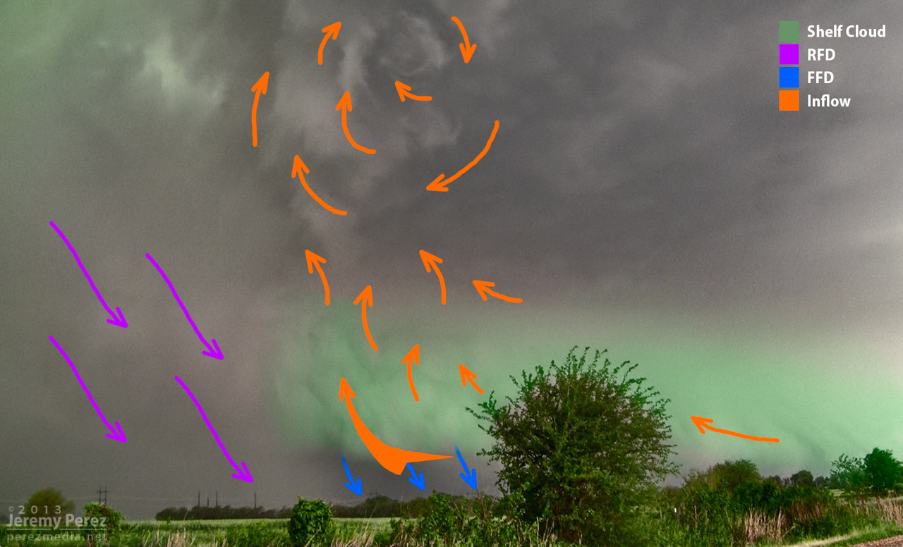
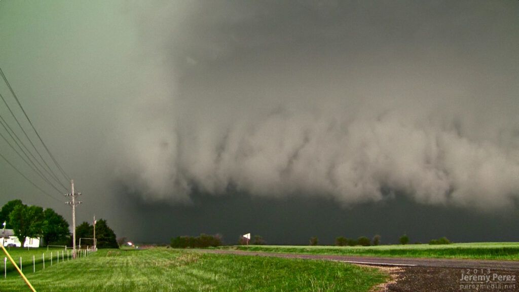
In my previous post, I diagrammed the Oxford, Kansas supercell from 19 May 2013. About 90 seconds after that shot was taken, a new area of low level rotation developed just ahead of the occlusion. This is a diagram of that moment as the inflow was forced into the updraft at that point and rapidly exposing circulation at the cloud base.
In 2010 after my first Great Plains chase, I spent a lot of time going through my photos and working to improve my understanding of storm structure. For one of those exercises, I diagrammed the Bowdle supercell. There was a lot of excellent feedback and discussion on all the structure in that beautiful, terrible, amazing storm.
Each new supercell I chase broadens my appreciation for all the ingredients and dynamics that make each one unique and awesome. I enjoy recapping each one and visualizing what was happening, so I’ve been keen to diagram some more recent storms.
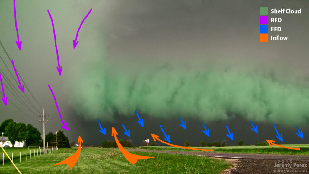
What I especially wanted to work on were transition points in space or time where a shelf cloud is merging or morphing into a wall cloud/tail cloud and vice-versa. A lot of times it’s pretty clear what’s what. But because the storm and its environment don’t care about taxonomy, there are plenty of cases where things ride along a diffuse spectrum. To me, it’s educational to watch these things unfold and look for transitions where one thing becomes another, and what that means for the fluid movement and interaction of near-storm air masses.
So, here is a batch of a few more.
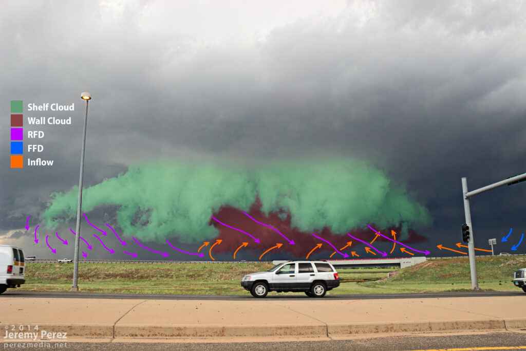
Denver Supercell – May 21, 2014
While this storm was still strengthening over Denver Metro and headed toward the airport, it had a very compact RFD shelf that I wanted to call a wall cloud at first glance. But the RFD appears to be responsible for lifting this prominent feature out ahead of the base while the true wall clouds spins away behind. Mike Olbinski’s time lapse nicely demonstrates the dynamics (See the 6:24 segment of the video).
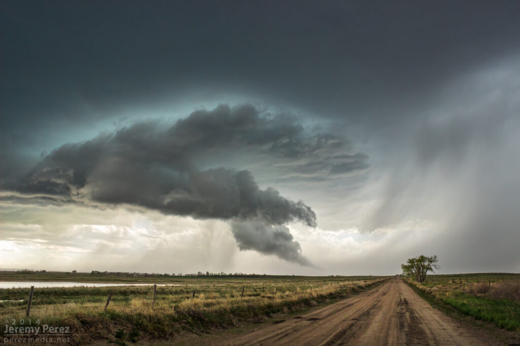
Goshen County Supercell – May 20, 2014
This was a view that to me, beautifully demonstrates the source of a weak wall cloud’s formation as the forward flank’s rain foot intrudes into the updraft, drastically lowering the condensation level in that area. How much of the foreground lowering would technically be considered a wall cloud vs. RFD shelf was questionable to me.
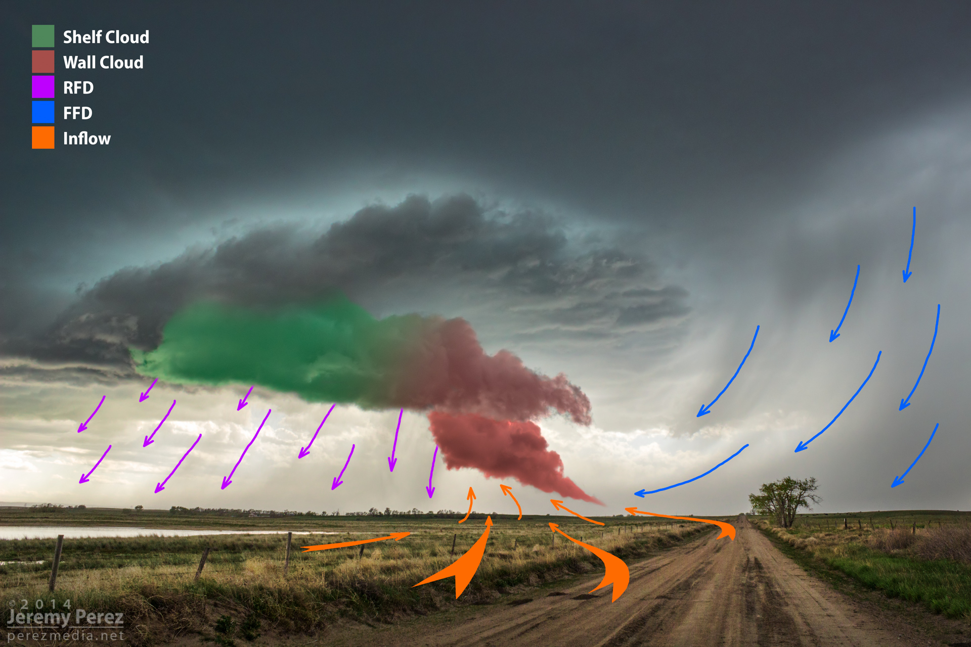
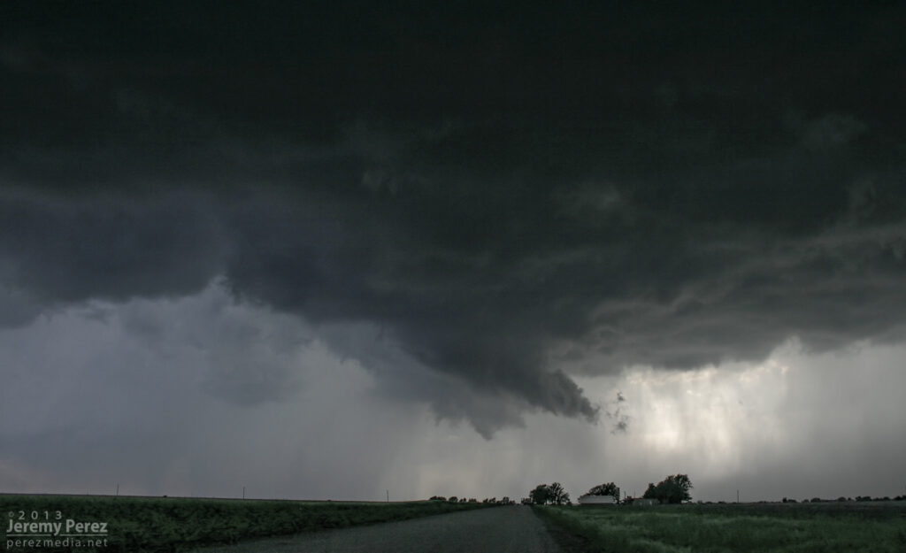
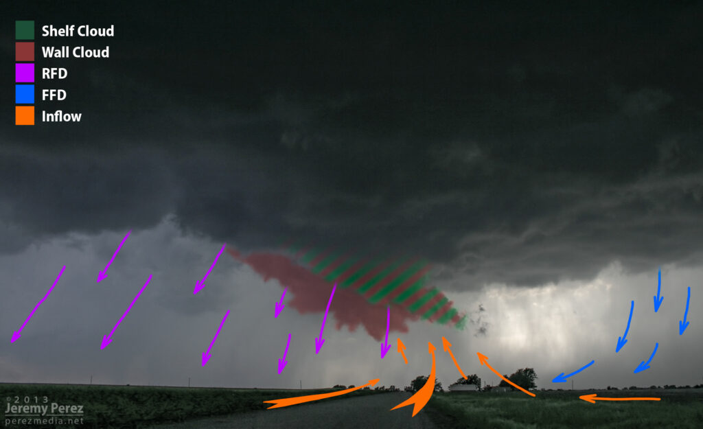
Newkirk, Oklahoma Supercell – May 19, 2013
This is an example of a transition point where the RFD is smearing a weak wall cloud into a shelf cloud. At least that’s how it seems to me. You can see that the foreground lowering is “pointing” toward the forward flank, and benefiting from lowered condensation as it rises into the base. But now it’s being hurried and lifted on its way by the RFD gust front (which it “points” away from). It seems to be in a place between both ‘definitions’ and both dynamic conditions.
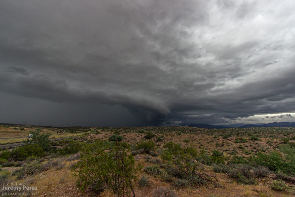
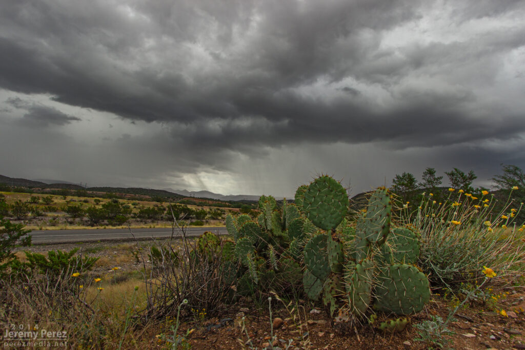
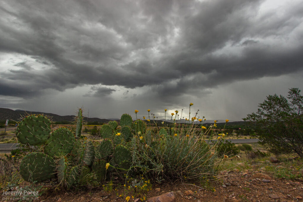
It’s been three years since I’ve had a really good storm chase in Arizona. This past Saturday, I had a chance to make up for the last couple of missed years. I wound up tracking three supercells along Highway 93 between I-40 and Wickenburg. The last of those three was difficult to observe due to bad positioning, surrounding convection, and unexpected freight trains, but the first two were spectacular amid some stunning Arizona landscapes.
The day before, I had set an initial target of Kingman, Arizona by sunrise, based on NAM and GFS placement of a closed low over Nevada. This was forecast to wrap up 30-50 kts of deep layer shear on top of a cold front over the Colorado river while rich moisture surged northward bringing mid 60 degree dew points. As is usually the case, targeting was based on a compromise between better instability further south vs. better dynamics further north. Instability and backed surface winds appeared to be maximized around daybreak and weakening by midday (1000-1500 j/kg with 100-150 m2/s2 SRH). By the night before, all models were trending downward on lapse rates, so forecast instability was dwindling. However, there was still enough to work with, and hodographs were very tantalizing by Arizona standards. This did adjust my perspective on positioning and timing. So I was able to get a bit more sleep and head out of Flagstaff a little later than planned (5AM instead of 3AM).
I stopped at Seligman about 6:00 AM. As I looked west, I was treated to a line of storms flickering with constant lightning as they trained along the cold front near Kingman. HRRR was forecasting the convection to quickly fill in eastward, along sheared out bands with some stronger embedded storms. HRRR’s version of SRH, bulk shear and CAPE still looked promising and was trending toward batches of storm helicity tracks over western Yavapai county by mid to late morning.
Anticrepuscular rays lead into a line of storms as seen looking west from Seligman, AZ. 6:05 AM / 1305Z
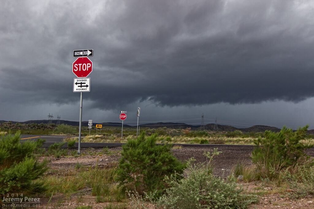
Once I reached Highway 93 a little before 8AM, a weak line of storms was passing overhead while a stronger line was approaching from the west. That stronger line featured a healthy cell just to my southwest with a persistent velocity couplet. It looked like it would cross Hwy 93 a couple miles south of I-40 and I had some difficulty deciding on which highway to intercept it (no decent side-road options in this area, just the two main perpendicular highways). I would have preferred the east-west option of I-40 for more fine-tuned positioning and safety margin on storms that are moving mainly northward. But I finally decided on my north-south Hwy 93 option since it would give more opportunities to pull off, start and stop instead of being trapped on the interstate with fewer offramps. As the updraft for the embedded cell moved by my position, it wasn’t much to look at, and just seemed to be putting a bit of a kink in the line.
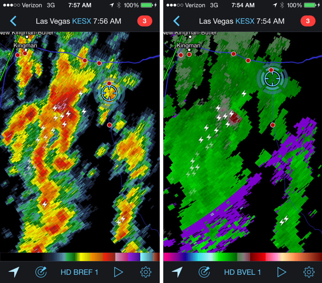
Updraft base in a line of convection as seen looking west from Highway 93 about six miles south of I-40. 8:10 AM / 1510ZA line of convection as seen looking west from Highway 93 about six miles south of I-40. 8:30 AM / 1530ZA supercell sports a lowering where the highway disappears into the hills. Meanwhile, trailing convection begins to merge into a bowing segment. View is to the northwest from Highway 93 a few miles south of I-40. 8:35 AM / 1535ZReflectivity and velocity radar of the embedded mesocyclone. 7:54 AM / 1454Z
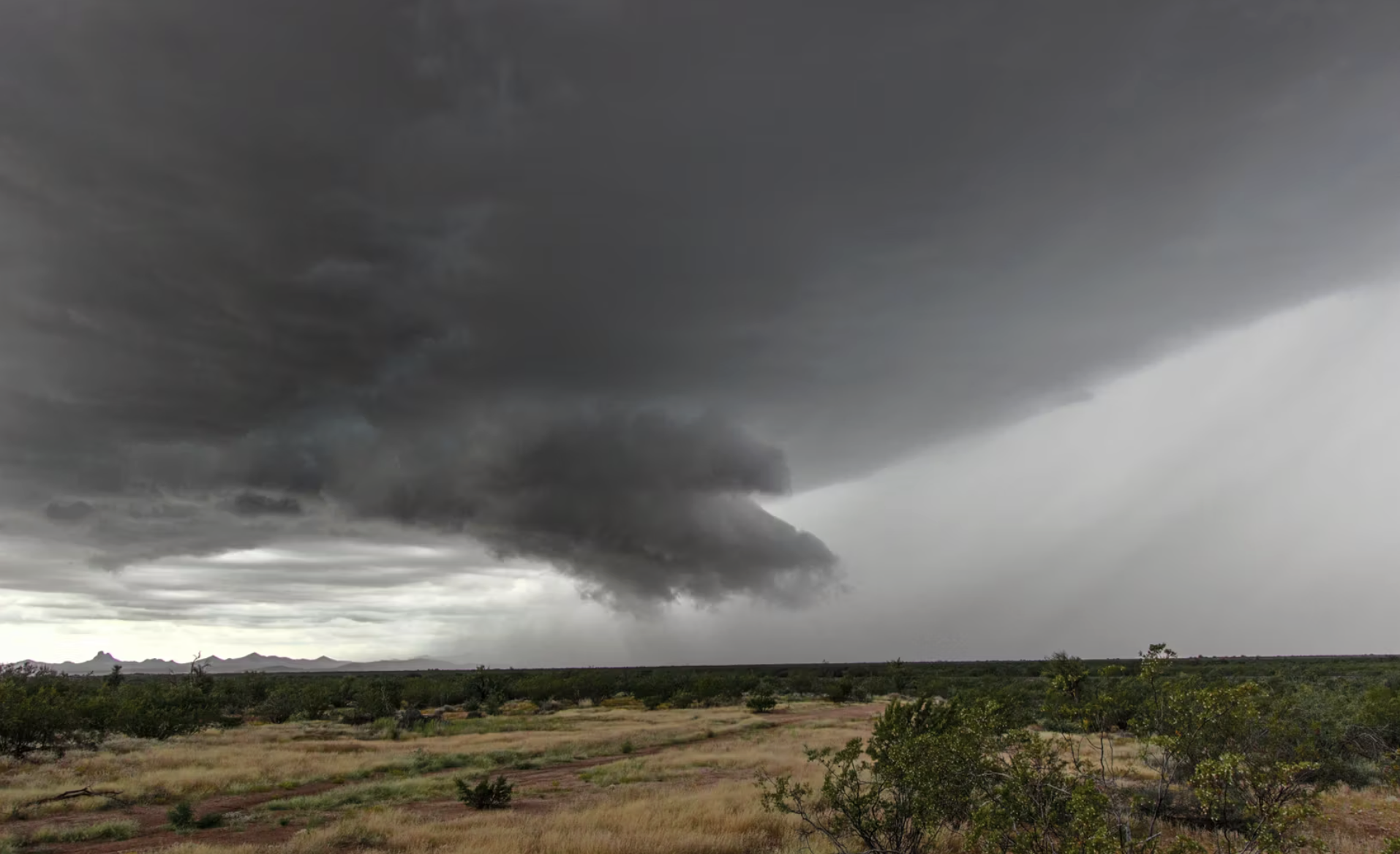
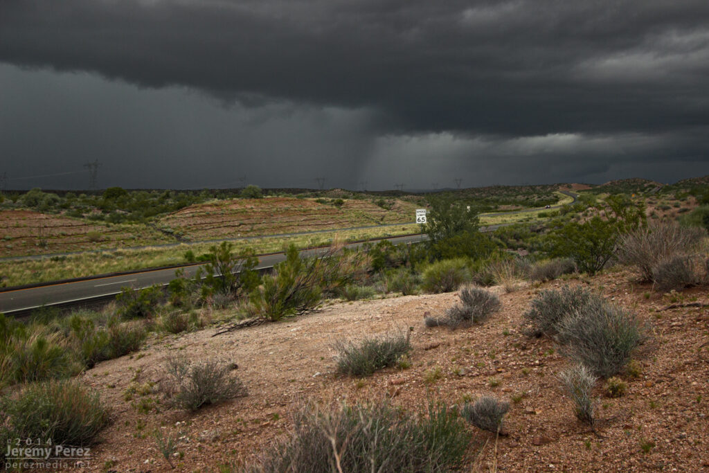
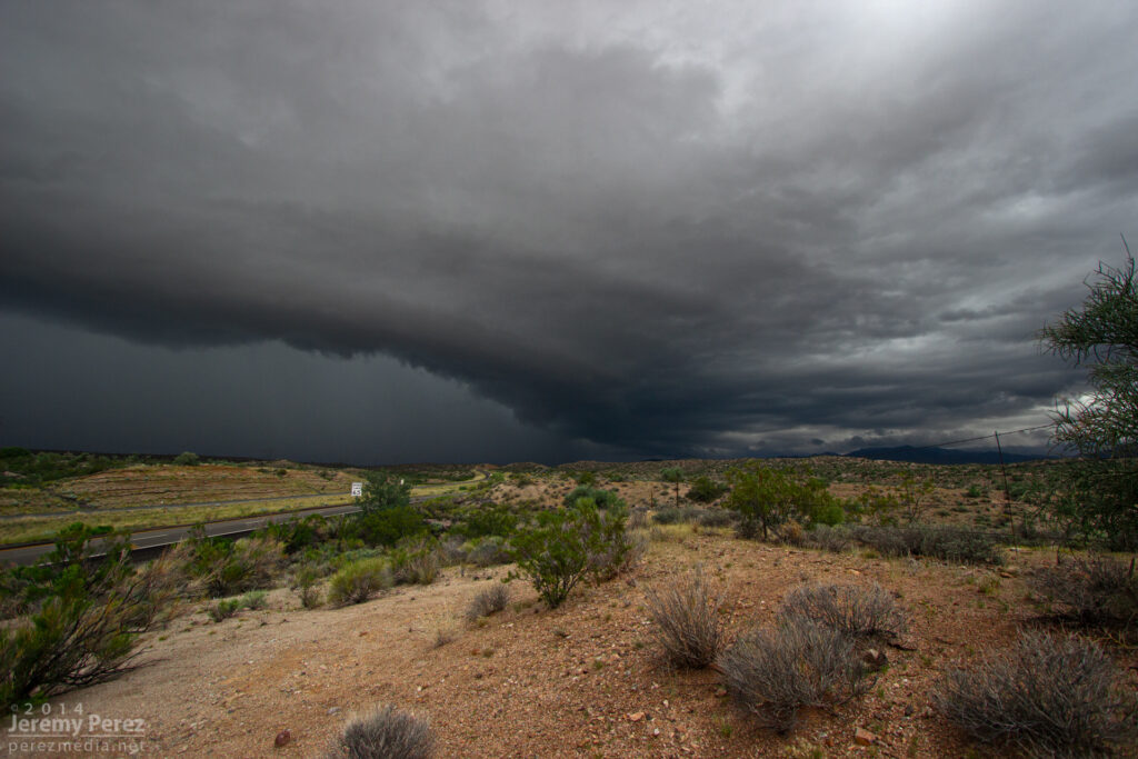
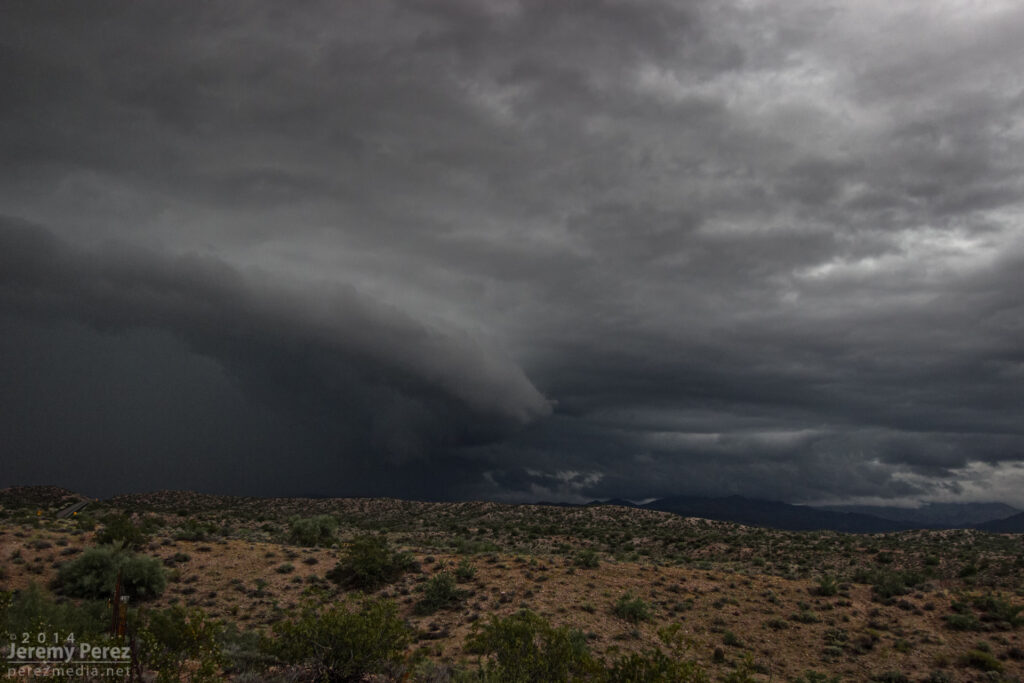
Because of the added safety cautions being on the north-south road, and new convection fluctuating to the south of my target cell, I decided to stay a lot further south of it than I wanted. About the time it neared the I-40/Hwy 89 junction, it didn’t look as strong on radar, but the trailing gust front finally pushed hard and it expanded outward in spectacular fashion. As a kink in the shelf took shape, a rugged, conical lowering materialized behind the surging gust front before getting smeared out.
The gust front south of a supercell pushes out over Highway 93 a few miles south of I-40. View is to the north. 8:40 AM / 1540ZA kink in the gust front develops, leading to a conical lowering. View is to the north from Highway 93. 8:40 AM / 1540ZA shelf cloud lines up along Highway 93. View is to the north. 8:45 AM / 1545Z
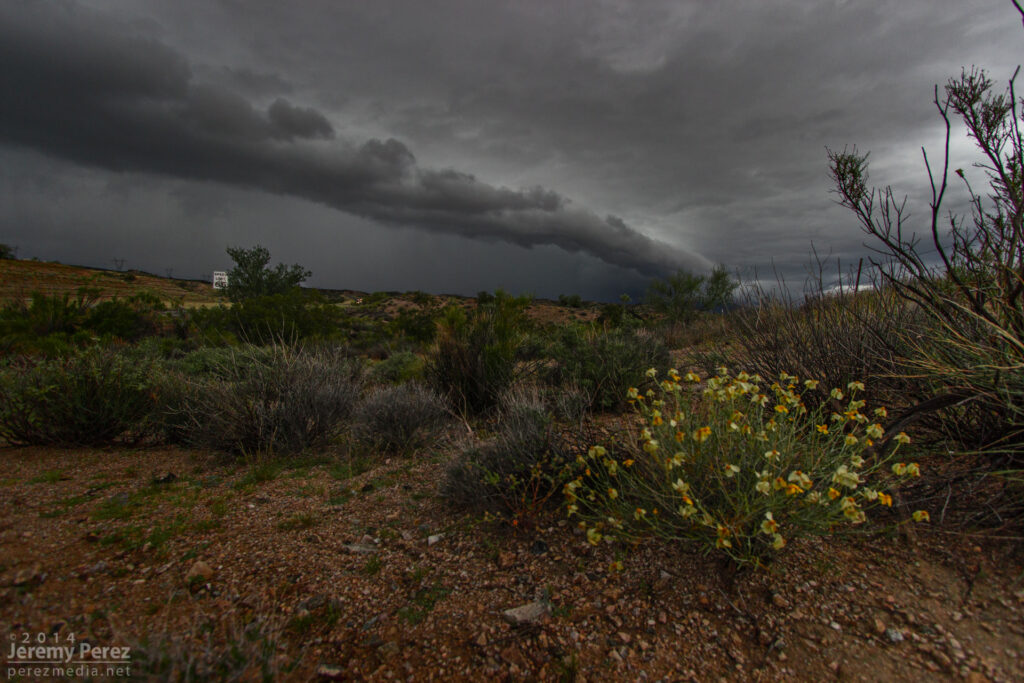
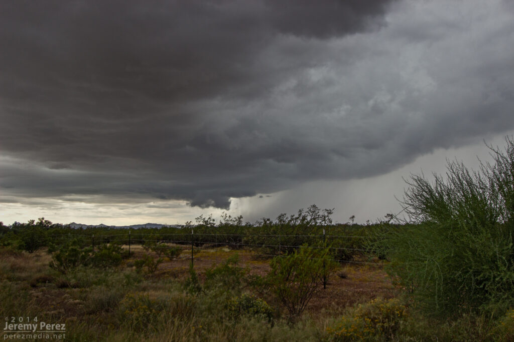
After that amazing encounter, I headed further south to get in front of some more developing convection. Along the way, I caught brief views of stronger updraft bases between precipitation cores, and irresistible stormy views in the desert terrain.
A dark rain free base peeks out from between two rain cores as seen from Highway 93 looking southwest. 9:50 AM / 1650ZDisorganized convection paints the sky above a soaked desert landscape. As seen from Highway 93 looking southeast. 10:20 AM / 1720Z
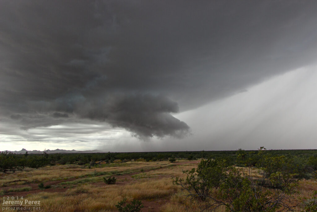
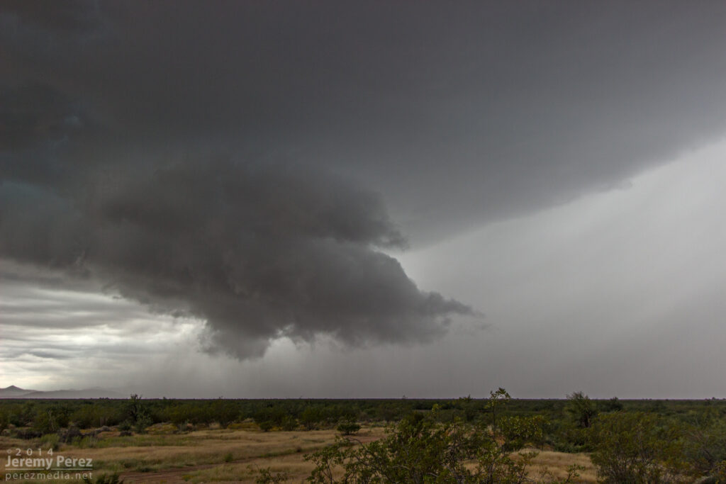
By this time, HRRR was trending toward better options further east into central Yavapai county. So I headed east to Congress when a strong cell with a developing couplet started moving in from the southwest, so I headed back south toward Wickenburg on Highway 89. As I cleared heavy rain on some cells popping up overhead, the base of the Wickenburg storm came into view. It was sporting a lowering and a huge tuft of scud was rising up from the ground to meet it. As that merged with the rain free base, the storm had the embryo of a wall cloud.
A wall cloud begins to form beside the forward flank of an approaching supercell. As seen from Highway 89 between Wickenburg and Congress looking southwest. 11:25 AM / 1825Z
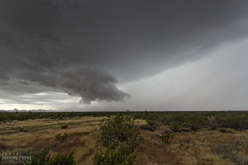
While photographing it, I noticed that the storm appeared to be deviating a bit to the right. So I jumped back in the car and headed further south to avoid getting cut off. During that short drive, the wall could got sturdier as it made attempts at a tail cloud along the interface of a the forward flank. It reminded me a lot of another beautiful supercell I intercepted in Wyoming back in May.
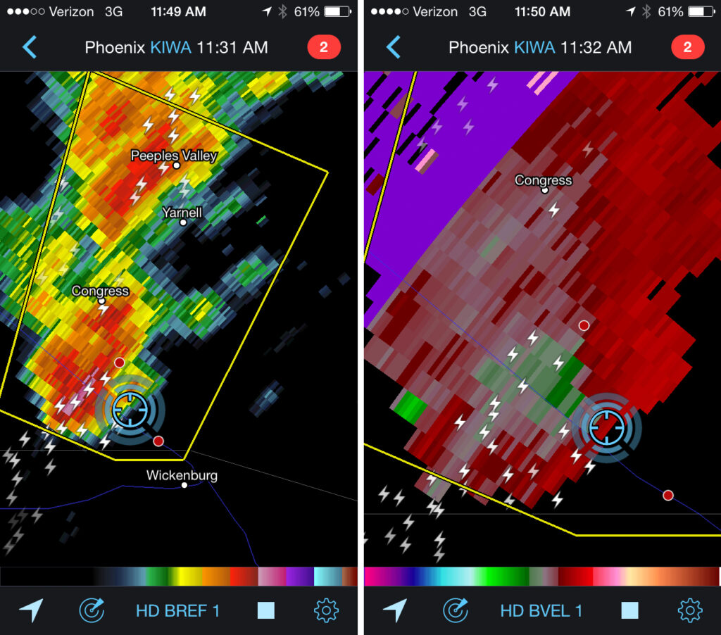
Wall cloud on a supercell north of Wickenburg. As seen from Highway 89 facing southwest. 11:30 AM / 1830ZReflectivity and velocity radar of the Wickenburg supercell. 11:32 AM / 1832Z
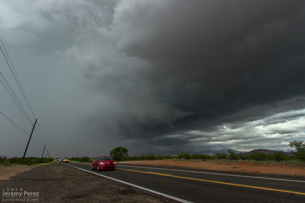
I was so busy trying to coordinate video and photography, and keeping track of overall storm motion that I couldn’t relax and see if any slow rotation was present. At this point, if there was any rotation in the wall cloud, it wasn’t fast enough to make me think it was about to plant something out in the mesquite and palo verdes. However what was concerning is that the storm was turning even further to the right and I had to hustle out of the way. As I raced south, I started getting shoved around by RFD that was starting to fill in with rain. Once I was clear, I got view of the back of the RFD core and right edge of the wall cloud as it moved away.
RFD partially obscures the rotating wall cloud on a receding supercell between Wickenburg and Congress. As seen from Highway 89 looking north-northeast. 11:35 AM / 1835Z
I still wasn’t confident if I was seeing low level rotation, but I did call it in to the Phoenix NWS office as exhibiting supercell structure. Looking at the video and time lapse sequences later, it definitely was twirling behind the RFD. The view of the entire cell moving away over the desert was incredible. The dark base and flanking line contrasted against the bright white RFD core and anvil against a deep blue sky. It was spectacular.
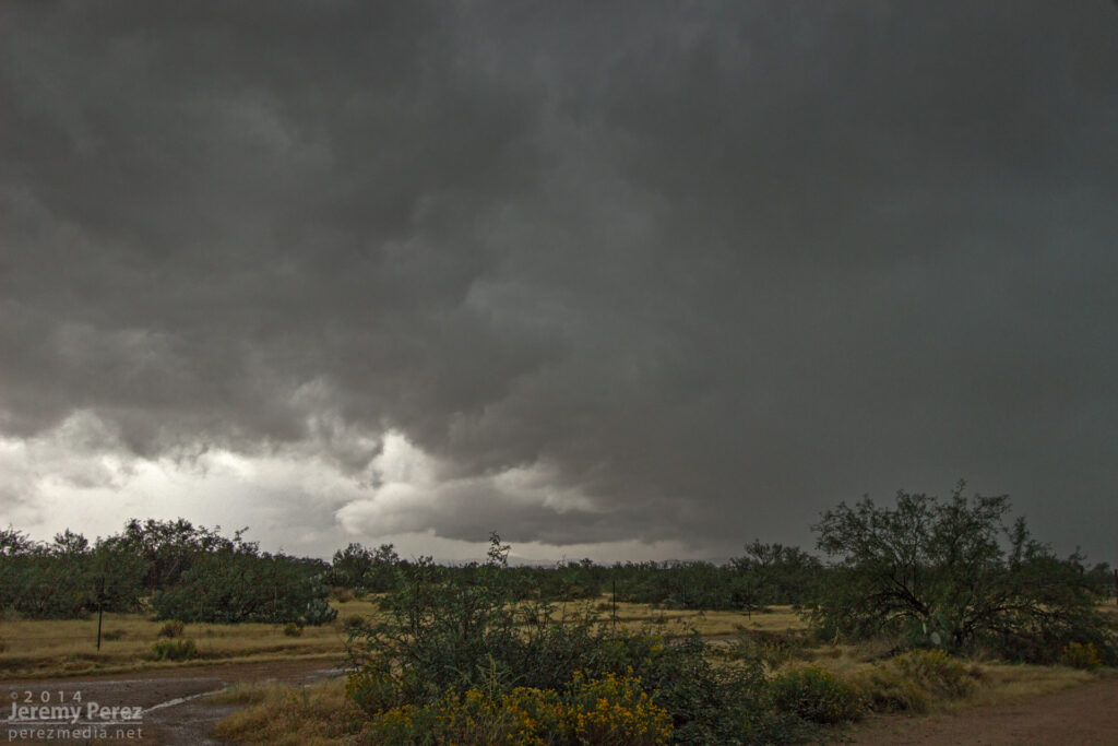
A receding supercell thunderstorm dumps rain and hail over Congress, AZ. As seen from Highway 89 looking north-northeast. 11:45 AM / 1845Z
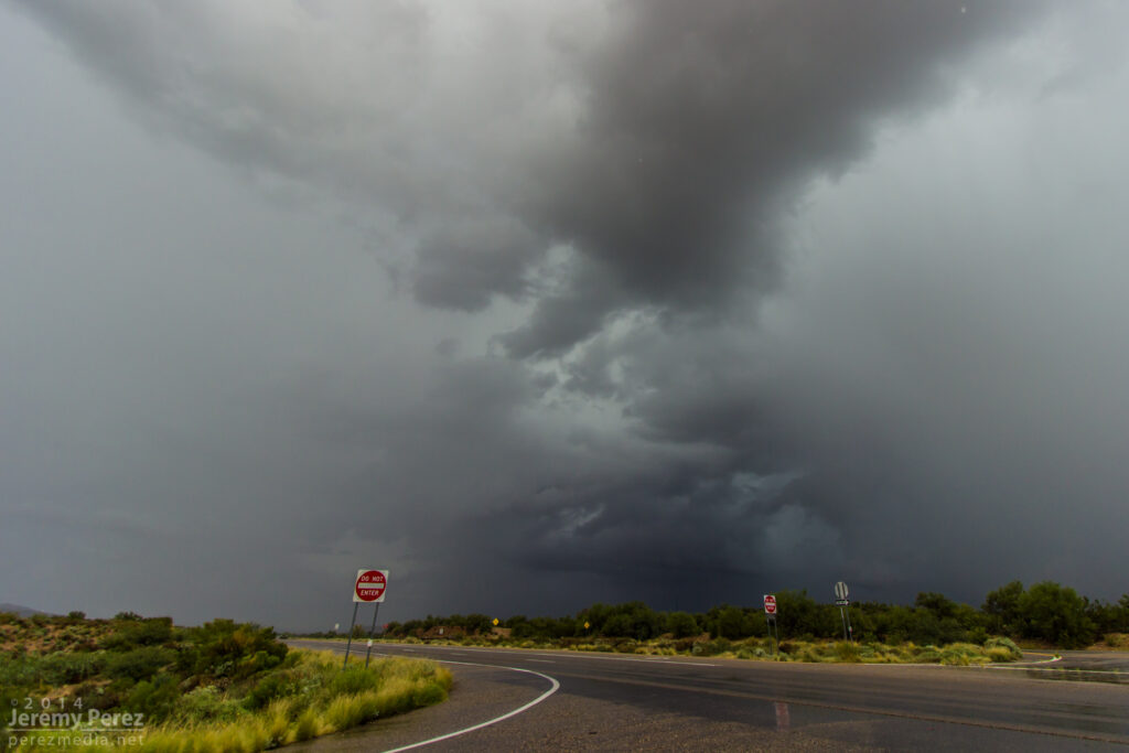
After savoring the experience, I had a choice between more cells moving into Yavapai County, or a building squall line moving into Phoenix. I was feeling a little hooked on the supercell storm mode, so I didn’t head into Phoenix for the amazing show that storm put on. Instead, I repositioned west of Congress for the next line of storms as another cell with a velocity couplet was moving in. Unfortunately, it was surrounded by more developing convection and I only had brief views of structure between morphing rain cores. I was about to make a hopefully decent intercept, but was stopped short as a freight train took its sweet time blocking my best approach.
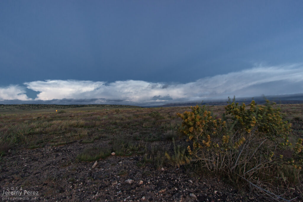
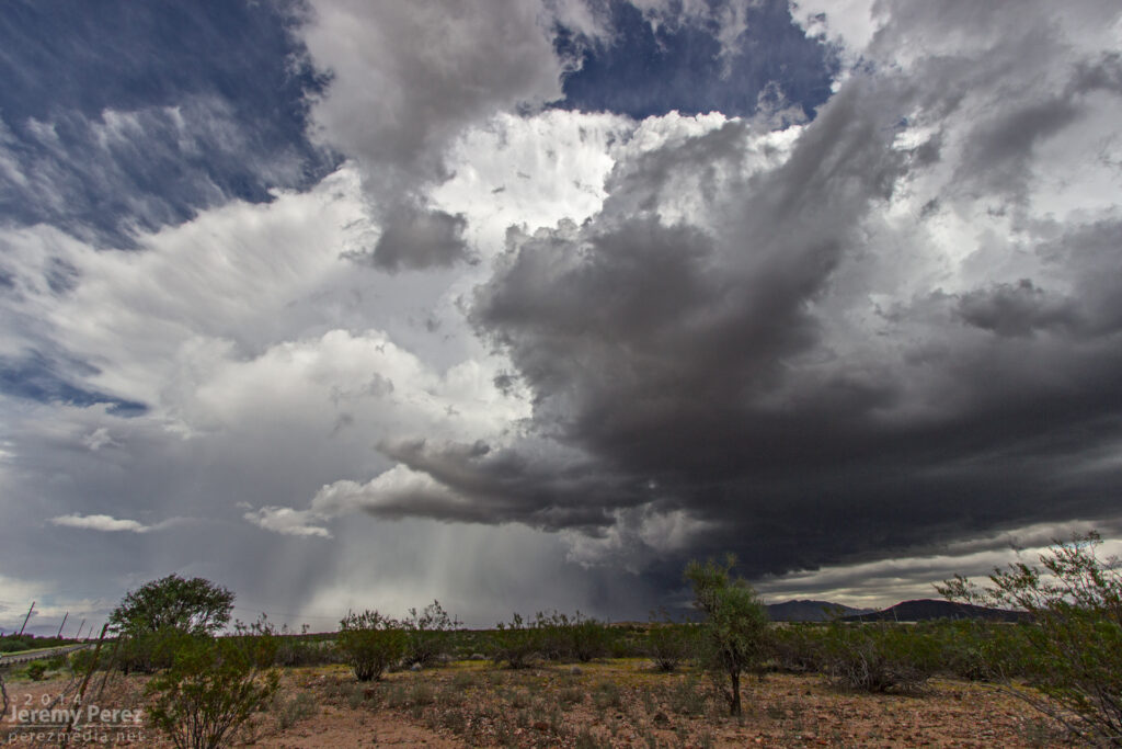
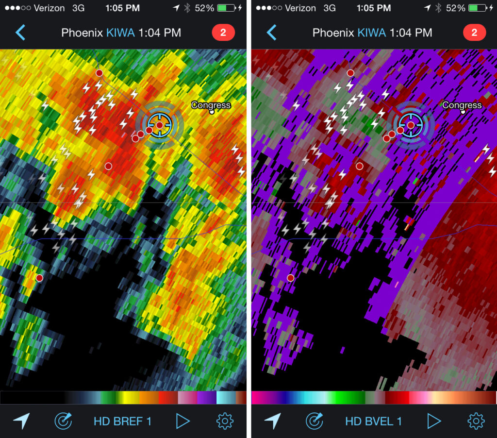
A striated shelf cloud approaches the intersection of Highway 93 and 71. The rain free base on this supercell was obscured by surrounding precipitation. View is to the southwest. 1:05 PM / 2005ZReflectivity and velocity radar of broad circulation in a passing storm. 1:04 PM / 2004ZA new updraft base forms to the south of a passing supercell as seen from Highway 71 in Congress, AZ. View is to the southwest. 1:15 PM / 2015Z
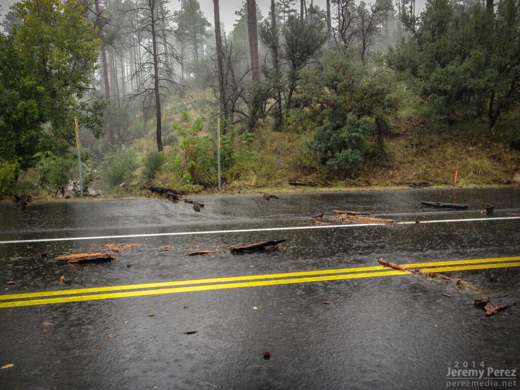
Once that storm was gone, I decided to take the scenic route back toward I-17 and took Highway 89 to Prescott. The long drive up the mountain switchbacks took me into the dark of the foggy cloud bases where mounds of small hail still survived in places against an onslaught of heavy rain. As I descended the east side of the mountain range I came across several sections of road that had recently seen flooding and had to stop at one point to pull an 8-inch diameter log out of the road while essentially taking a full on shower.
Flash flood debris on Highway 89 just south of Prescott (Had already pulled the huge log out of the road at this point). 2:56 PM / 2156Z
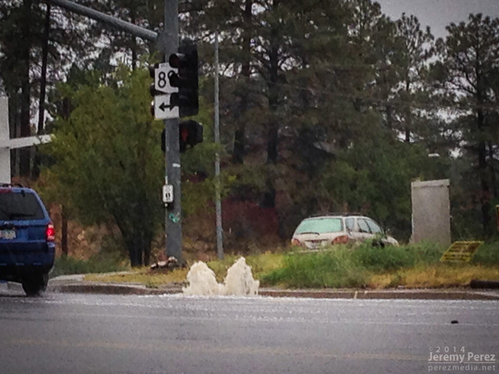
As I made my way into Prescott, DPS was roaming around pulling debris out of the streets. Further in, I passed a storm drain that was fountaining water, and the town was a waterlogged, debris strewn mess. The worst had passed though, and there were no ‘turn around don’t drown’ scenarios to deal with.
Overloaded storm drain in Prescott. 3:04 PM / 2204Z
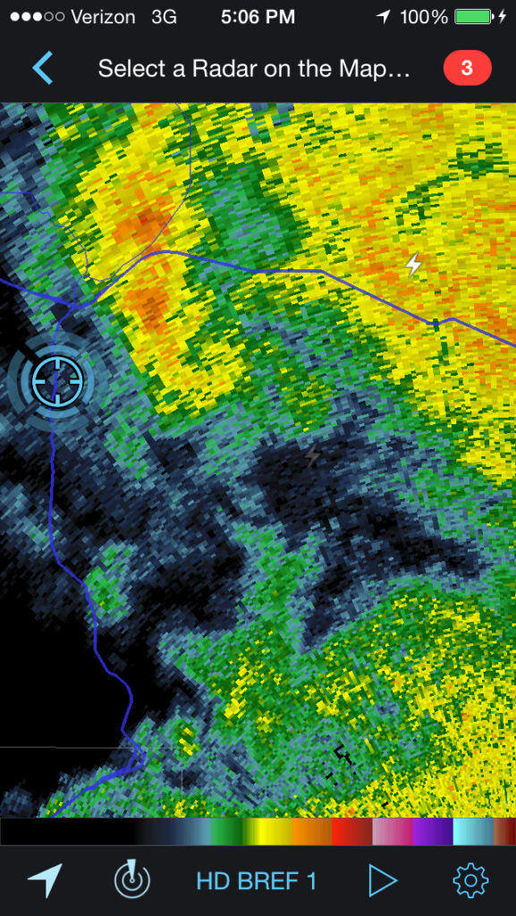
As I made my way up I-17 back to Flagstaff, I skirted the west edge of the weakening line of storms and noticed an eddy on radar moving over east Flagstaff. Looks like this might have been a bookend vortex on the line. I wish I could have seen what that looked like, but that will have to wait for another time.
Reflectivity radar of possible bookend vortex southeast of Flagstaff. 5:06 PM / 0006Z
What an amazing chase. No tornadoes, but three Arizona supercells in one chase day is so much better than I could have hoped for. It has me seriously itching for springtime in the Plains—only 6 or 7 months to go!
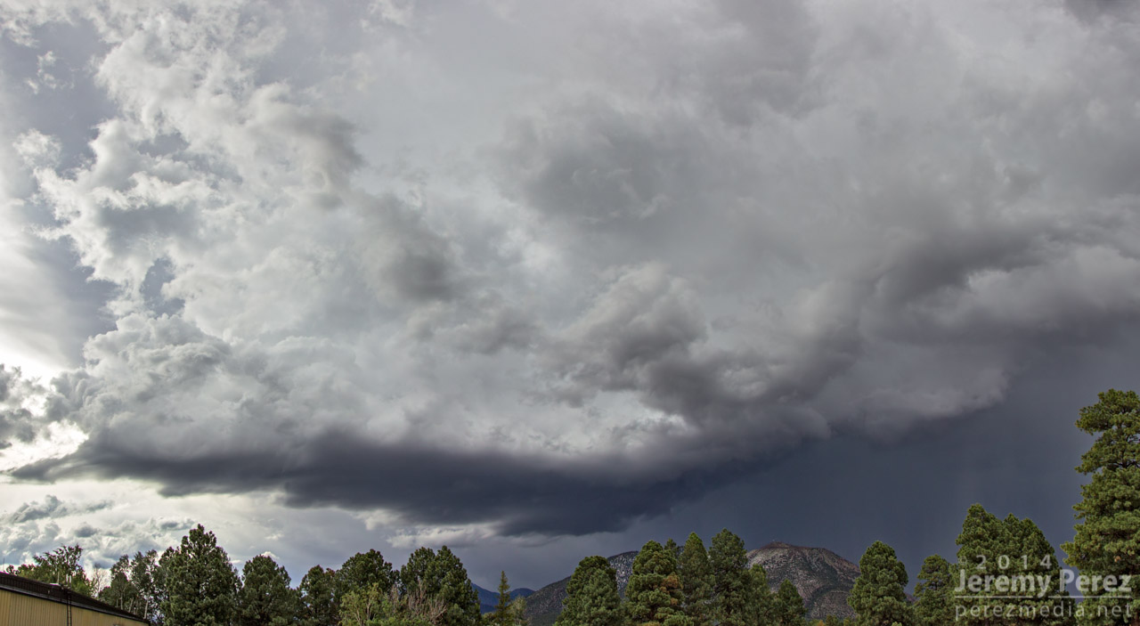
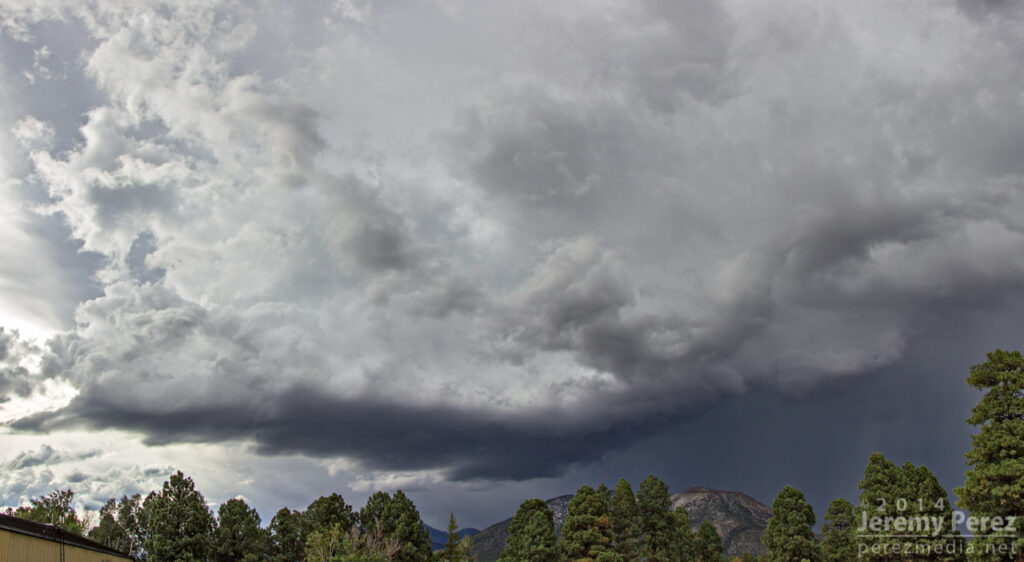
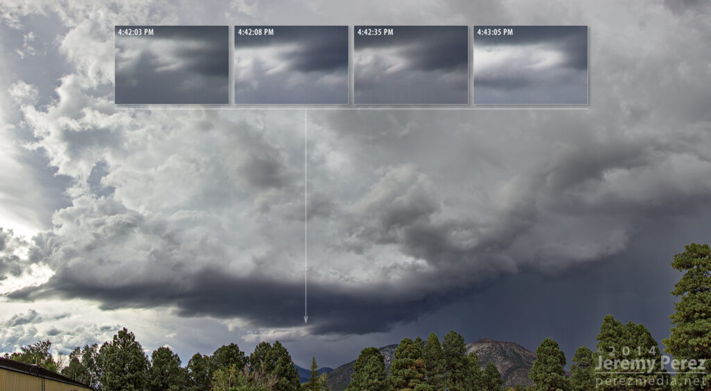
Today, a strong multicell hammered east Flagstaff, dropping up to 2 inches of precipitation including mounds of hail during a 45 minute time frame. Some meager vorticity got stretched into the blue-green updrafts at times and made me wish I had a better vantage.
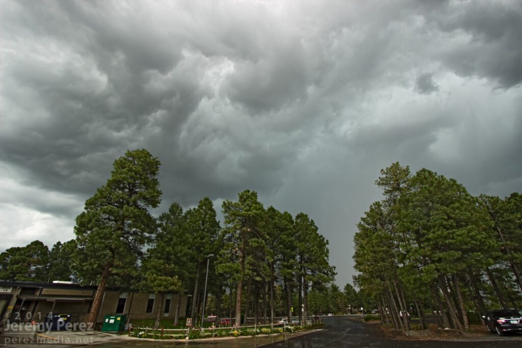
Still, the view from the middle of town was pretty good as a clearing eventually showed a nice rain free base west of Mt. Elden.
I noticed some laminar striation under the base, but thought it was just an indication of strong inflow. After checking the photos, I noticed that structure may have actually been a shear funnel that lasted a little more than a minute from 4:42 to 4:43 PM.
I wasn’t fully prepared, and decided to shoot a 96 frame time lapse when all I had was a monopod. After Effects stabilization managed to rescue the time lapse pretty nicely.
So much for Virtual Chases. I’m planning to head out to the plains for a few days to try chasing some marginal setups. Not sure if I’ll be able to post a forecast ahead of each day, but I’ll start with my first opportunity this Sunday.
Target: Northeast Wyoming
With all the frustrations of a flimsy severe weather pattern setting in for the latter half of May, it still looks like there will be isolated/conditional opportunities in the northern plains and elsewhere as a trough moves onshore this weekend and starts cutting off in the southwest early in the week.
For Sunday afternoon/evening, per guidance from NAM, I’m looking at a target in northeastern Wyoming as 40-50 kts of southwest H5 flow moves in over an area of low to mid 50 dew points advects around a consolidating surface low in that target area. A narrow, meridional zone of 1500-2000 j/kg CAPE will develop along the eastern Wyoming border with the CAP weak or open by mid to late afternoon in the northern portion of this ribbon. Today’s 12Z NAM forecasts a focal point for convection in this area by 00Z with that area potentially ingesting 100-150 m2/s2 0-1km SRH. Mixed layer LCLs are in the 1500 meter range and heighten quickly the further south you go.
If this plays out well, I might hope to see an isolated, high-based supercell drifting slowly into South Dakota. I have no expectations of anything tornadic with this setup. And if today’s 06Z GFS has its way, then I can expect a bust with maybe some elevated showers in South Dakota (GFS keeps surface moisture about a hundred miles further east under stronger capping). 00Z ECMWF agrees better with NAM on placement of moisture and location of precipitation, so I hope that agreement favors my focus on NAM.
This will be my first 2014 chase day during a week of very iffy conditions. I’m definitely concerned that I’m setting myself up for a series of busts, but also excited to take on the challenge.
I’m relying on guidance from NAM for this forecast and have run out of time to compare with GFS.
A surface low will be consolidating over western kentucky as afternoon progresses. A warm front will be established northeast of the low through southern Indiana, and northern Ohio. A cold front will nudge into western Kentucky/Tennessee and eastern Mississippi. Mid 60 dew points will advect into the warm sector. CAPE values of 1500 j/kg reside from central Kentucky northeastward across southeastern half of Ohio and western Pennsylvania while a pocket of 2000+ j/kg resides over southern Ohio during the afternoon.
Mid level jet placing 40-50 kts of bulk shear over boundaries with enough extending over the warm side to affect convection. Strong 0-1 km SRH resides mainly north of the boundaries, but stronger pockets develop over western Kentucky during early afternoon, and 100+ m2/s2 over southeastern Ohio toward 00Z. Convection is forecast to be ongoing and messy throughout the day, so it’s difficult to for me to anticipate how that plays out in this area. My target is in southeast Ohio where 0-1km EHI rises over 1.5 by 00Z and the lid strength index points to wide openings for surface based storms in the area.
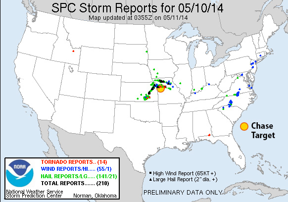
Results
Nearest Tornado Report: 94 Miles West-southwest Nearest Severe Report: 3 Miles Southeast [Hail: 1.5 inch]
A trough over the rockies places 50kt H5 flow from the Texas/Oklahoma Panhandles through Kansas, Nebraska and Iowa by midday. The trough tightens over the afternoon, weakening flow across Iowa to just the extreme southwest part of the state.
A surface low over western Kansas drapes a sharp dryline southward across far east border of the Texas Panhandle and southward from there. At midday, a cold front lines up from the central Kansas/Nebraska border through southwest Iowa and then a warm front up to northeast Iowa. By 00Z, the boundaries have advanced across northeast Nebraska and northern Iowa. East and south of the dryline/cold front/warm front, CAPE values reach or exceed 3000 j/kg by 21Z. LCLs will be rising throughout the warm sector throughout the day, but the southeast Nebraska and southern Iowa have best opportunity to remain at or below 1000 m through 00Z. After that, they lower to 500-750 m across Iowa.
0-1km SRH gets over 100 m2/s2 on the warm side of the boundary, and spiking over 300 m2/s2 immediately on the other side. Hodographs along the warm front have huge, open, clockwise hodographs. Pretty scary actually. Southeast Nebraska at 21Z shows 0-1km EHI over 3 while Iowa waits until 00Z to reach that level. NAM convective forecast puts discrete cells and then ongoing convection in southeast Nebraska as well.
Results
Nearest Tornado Report: 10.9 Miles Northwest Nearest Severe Report: 9 Miles West [Wind: 60 MPH]
A monster supercell erupted in south-central Nebraska and tracked east-northeast along the warm front north of Lincoln, and then north of my target of Ashland before moving into Omaha. It was a long track tornado producer, with the closest tornado report being 10.9 miles northwest of Ashland. A scattering of other tornado reports came from far southeast and far northeast Iowa/far southeast South Dakota, as well as a few from a dryline storm in central Kansas.
At 21Z a surface trough will stretch from North Dakota to northeast Kansas, migrating slowly southeast. A cold front will drape from the Nebraska/Iowa border, across east Kansas and into northwest Oklahoma where it transitions to a dryline southward across west Texas. Mid to possibly upper 60 dewpoints will be pushing northward into northern Missouri on 15-20 kt surface winds. As convection fires from 18Z-21Z, MLCAPE values could reach 3000 j/kg east of the front, with NAM aggressively plotting 4000 j/kg in west-central Missouri.
Mid/upper level support takes the form of only slightly amplified flow with pockets of 40 kts at 500 mb across the central plains and into the midwest. The warm sector appears to get its best support across the northeastern three-fourths of Missouri with 50 knots of bulk shear over northwest and north central parts of the state. 0-1km SRH reaches 150 m2/s2 over the northwest quadrant of Missouri as well by 00Z.
NAM forecasts convection firing in this better zone by 21Z with open, clockwise forecast hodographs showing up in both NAM and GFS. Lid Strength Index opens a brief opportunity for surface based storms in the 21Z time frame in this northwest Missouri as well, so placing my target at Odessa, east of Kansas City.
Results
Nearest Tornado Report: 16 Miles North-northeast Nearest Severe Report: Same
Numerous severe storms erupted along the cold front and dryline around 20Z with a few supercells turning right and strengthening. The one that passed just north of Odessa generated a few tornado reports—the nearest 16 miles to the north-northeast.
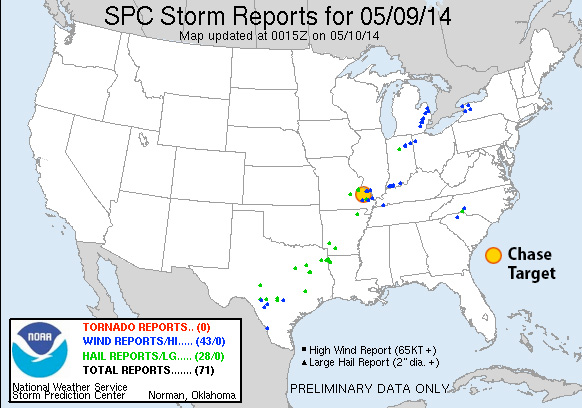
I didn’t have a lot of time to prepare this. I targeted a location east of the cold front in southeast Missouri where the H5 speed max would provide bulk shear in the 40-50kt range between 21Z-03Z. NAM forecasts dew points in the mid 60s in southwest Missouri with CAPE reaching 2000 j/kg. 0-1 km SRH is not good, reaching maybe into 100 m2/s2 after 00Z, so I don’t see more than a very odd chance at tornado potential. NAM forecasts better parameters and reflectivity further north than GFS, so I tried to split the difference between them.
Results
Nearest Tornado Report: None Reported Nearest Severe Report: 16 Miles North-northwest [Hail: 1 inch] || 25 Miles Northeast [Wind: Roof off house]
Insolation had an early start in my target area, which helped several severe warned and two tornado warned storms pass near Fredericktown. A wind report 35 miles south had this to say:
3 S GREENVILLE Wind Report County, State: WAYNE, MO (marker location is approximate) Lat.: 37.08, Lon.: -90.45 Time: 2014-05-09 20:00 UTC Wind Speed: Unknown TREE LIMBS DOWN AND DAMAGE TO CAMPER AWNINGS AT THE OLD GREENVILLE CAMPGROUND. UNCONFIRMED REPORT OF FUNNEL CLOUD ASSOCIATED WITH DAMAGE. DAMAGE PATH ESTIMATED AROUND O (PAH)
A surface low migrates from northeast Neblaska to southwest Minnesota. A dryline/cold front drapes from east Iowa through central Kansas and western Oklahoma / central Texal with dew points into the mid 60s in the warm sector. CAPE reaches 2500 j/kg near the triple point through the northwest half of Iowa and southern Minnesota while moving rapidly northward into central Minnesota as the cold front works on occluding the surface low.
The upper trough lifts a 60 kt mid level speed max over the dryline/coldfront/surface low. Bulk shear over the northern two-thirds of this boundary starts at 60 kts at midday and drops to 40-50 kts by evening. 0-1km SRH hits 150 m2/s2 east of the surface boundary and over 200 m2/s2 to the north and northeast of the surface low.
Maximized EHI follows this position from far northeast Nebraska at 18Z to northwest Iowa by 21Z and southeast Minnesota by 00Z with 21Z having the greatest potential, but too strongly capped. Reflectivity forecast shows triple-point storms firing by 00Z in south-central Minnesota with large open hodographs, and marks my target area.
Results
Nearest Tornado Report: 38 Miles South-southeast Nearest Severe Report: 19 Miles South-southwest [1.5 Inch Hail]
The warm front did not lift as far north as I anticipated from yesterday’s model runs. However, a couple supercells managed to take advantage of low level helicity along the warm front south of my target area and did produce tornadoes. One of those reports was 38 miles to the south-southeast of Litchfield.
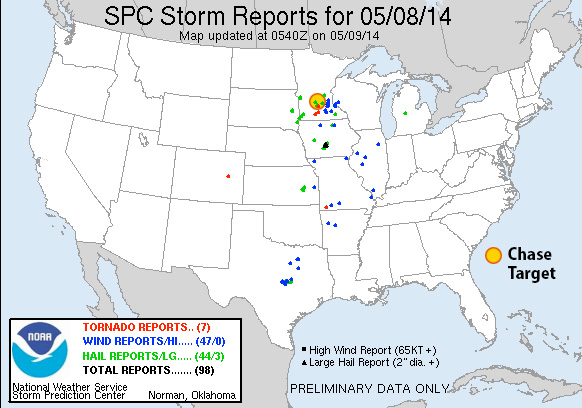
Looking at the southern portion of this setup: it features a fairly neutral-tilt trough over western US with 50-60kt 500 Mb speed max edging eastward over the Panhandles/western Oklahoma/northwest Texas/southwest Kansas. The 18Z NAM forecasts 40-50kt bulk shear over northwest texas to northwest Oklahoma by 00Z and increasing thereafter. The 18Z GFS spreads that out more, but pushes it further northwest. An elongated surface trough is forecast to tighten up from northeast Colorado to eastern Nebraska with a dryline retreating westward during the afternoon/evening and ending up at 00Z from western Iowa through central Kansas, southwest Oklahoma and south from there into Texas with mid 60 dewpoints in place. CAPE values range from 2000 (GFS) to 3000 (NAM) j/kg east of the dryline by mid-late afternoon. By 00Z, GFS breaks out convection north of the Red River while NAM plants south of the Red River. Both models/areas feature widening hodographs toward and after sunset. NAM features EHI building from 1.0-3.0 around and south of Vernon Texas from 00Z-03Z with 0-1km SRH approaching 300 m2/s2 by 03Z. LCLs start to drop toward 1,000 meters from 00Z-03Z as well.
[Update 1515Z:] Latest NAM, HRRR and RAP reflectivity forecasts are showing some differences in where convection will initiate and strengthen. 06Z and 12Z NAM fires things up right over my target area. RAP and 12Z HRRR however are lighting up further east at mid afternoon with HRRR firing a weaker second round over my target area a couple hours later. It seems like HRRR is anticipating the dryline sitting further east around 21Z when convection initiates, and then the dryline starts retreating right after that. I’m interested to see if SPC nudges the risk area eastward or not. The difference is about 50 miles, so if I were there, I’d be pleased to just sit in my current location, watch the dryline mark itself out, and then adjust if needed as cumulus gets more agitated.
Results
Nearest Tornado Report: 30 Miles Southeast Nearest Severe Report: 18 Miles East-northeast [1.5 Inch Hail]
Storms that fired near southwest Oklahoma did fairly well toward 00Z with a tornado-warned cell crossing the Red River near my target area. Apparently there was a spotter report of a tornado near Burkburnett, but I haven’t seen it posted to SPC storm reports as of 0500Z.
[Update May 8, 2014:] SPC is still updating storm reports, and have now plotted two new tornado reports: 30 miles southeast of my target, near Burkburnett, and 40 miles north-northeast, in the Wichita Mountain Wildlife Refuge.
A surface low is forecast to elongate over Wisconsin and Ohio with a cold front draping through eastern Tennessee through the Florida panhandle and migrating slowly eastward. The upper low will be over Iowa with 70 kt 500 mb flow flow aligned over cold front with 35-40 kts extending out over the warm sector to the east leading to 35-40 kts of bulk shear in that area.
Dewpoints from 65-70 will be in place from Florida through east Virginia. NAM and GFS paint different pictures of early convection/cloud cover/surface heating and subsequent CAPE values. If GFS pans out, 2000 j/kg CAPE will build from the Florida panhandle through central Georgia and South Carolina. If NAM pans out, some smaller pockets of 2000 j/kg will build along coastal Georgia/far south South Carolina. RAP so far looks like it’s splitting the difference between NAM and GFS on the situation.
00Z NAM paints large pockets of 100-150 m2/s2 0-1km SRH through central Georgia and more broadly north of there, reaching over 200 m2/s2 from western North Carolina and Virginia. Timing of the convection is variable across the models, could take the form discrete storms, a line, a broken line, a boggy mess. The best compromise of moderate CAPE, SRH, and bulk shear seems to be at the Georgia/South Carolina border close to the coast.
[Edit 1500Z:] Oh man…there goes my forecast area again, immersed in another MCS outflow & anvil festival. I may pull the plug on the chase case opp in the next hour.
[Edit 1530Z:] Alright, I’m going to leave my target in place and let the chips fall where they may. Current satellite trend looks like anvil cover is thinning gradually, and radar appears to show the MCS being progressive, instead of squatting over one area like yesterday. Probably wishful thinking, but maybe there will be enough clearing for the airmass to recover. Or maybe I’ll see a random wind report.
Results:
Nearest Tornado Report: None Nearest Severe Report: 198 Miles Northeast [Wind Report]
MCS Forecast Botch #2. Between today, yesterday, and my 2011 experience, this is definitely a weakness for me. What do I look for to say, yeah—the models aren’t picking up that today’s storms are going to get comfy and build a cold, wet nest all over tomorrow’s boundary layer? It doesn’t just put a hole in the setup where you can drive a couple hours and be out of it—the stable blanket lays over multiple states, and may just be a situation of deciding to start the long drive home the night before if you know it’s going to pan out that way. Research.
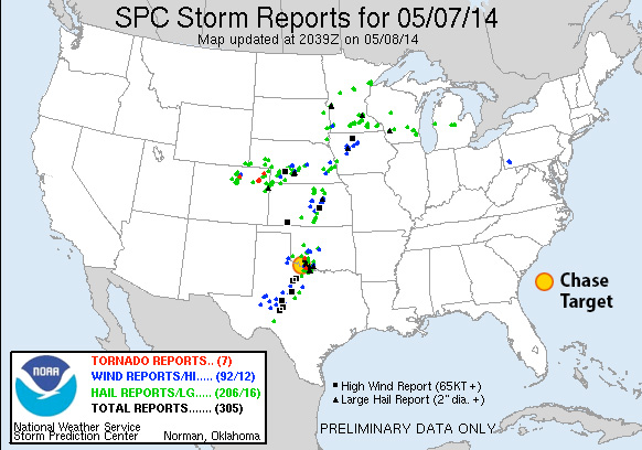
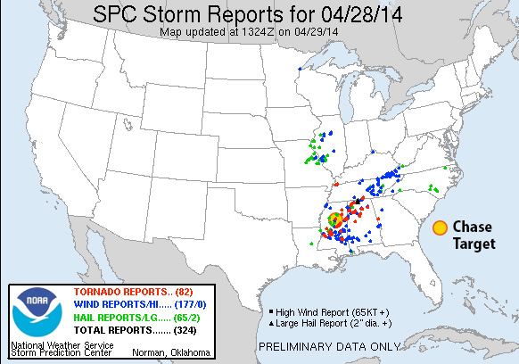
Upper level low over easter Iowa with 70-80 kts of flow over Louisiana/Mississippi/Alabama. Surface low is stacked right under its upper level partner. A cold front wraps through western Kentucky/Tennessee, northwest Mississippi and northern Louisiana at 18Z and pushing slowly southeastward during the afternoon. Upper 60 to 70 degree dew points are in place early with surface winds veered more strongly the further north you go approaching the front. CAPE values over the southeastern two-thirds of Mississippi, boot of Louisiana, and west-central Alabama start off over 3000 j/kg at 18Z and get eaten away by convection as the day goes on. Bulk shear over this strong instability is over 60 knots early on but relinquishes its hold over most of southern Alabama by late afternoon. 0-1km SRH is in the 150 m^2/s^2 over the southern third and a central pocket of Mississippi and floats ahead of developing convection. EHI is pegged over 3 in those central and southern pockets of Mississippi at 18Z when convection is heating up. Convective models show an early start to storms with supercells forming by midday in Mississippi and moving into Alabama during the afternoon. This is still early, messy convection and difficult to untangle options.
[Edit/Update 2230Z:] An ongoing MCS from yesterday’s storms on the gulf coast has not given up all day. Outflow and massive anvil cirrus has kept the southern two-thirds of Alabama and southeastern quadrant of Mississippi from heating up and reaching forecast instability. Storms have been trying to get going ahead of the cold front across Mississippi—much later than anticipated—but struggling much of the past couple hours. One storm about 70 miles southeast of my target area has picked up a tornado warning and is moving roughly eastward. It’s pretty strung out, the velocity couplets look anemic to my eye, and it’s not moving into better instability. So hard to say if it will last long.
Results:
Nearest Tornado Report: 632 Miles East-northeast …ehhh, probably ridiculous I’m tallying that… Nearest Severe Report: 64 Miles West-southwest [1 Inch Hail]
It’s amazing how soundly the non-stop MCS on the gulf coast turned the severe risk around for the region. Reminds me of May 11, 2011, when I woke up from the roach motel in Pratt, Kansas, on theoretically the strongest setup of the trip, to find an unexpected MCS and inbound anvils from Texas completely erasing the storm environment. It sure is a lot better to tank a forecast from home than 800 miles out! (The tornado-warned cell that was approaching Paulding did drop some meager hail with a couple reports 64+ miles out.) It’s a great relief all around that communities in the south got a reprieve from the last couple days of ruthless weather.
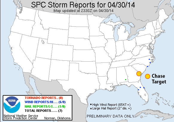
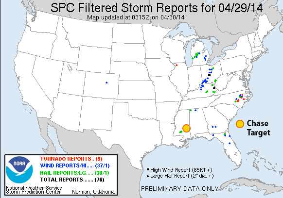
The closed upper low over eastern Kansas/Nebraska won’t have moved much in 24 hours. The surface low is pretty closely stacked at the Nebraska/Iowa border with a cold front/dryline arcing along eastern Missouri, Arkansas and Louisiana. Organized convection is forecast (per NAM) to start firing up around 15Z along the western Mississippi border. CAPE grows toward 2000+ j/kg ahead of this convection, better the further south you go, but capping appears to be a challenge and may prevent surface based convection. Upper air support is in good shape, at 60 kts early on. There is no standout location to me, other than staying north of heavier capping, but still south enough enough to find better instability. Forecast reflectivity and precipitation is a mess and difficult to interpret. SRH gets better as the day goes on, so trying to position a bit further east to give the line of storms time to take advantage of that. Once again, not an area i would chase, and definitely a setup I’m even less comfortable forecasting a chase target.
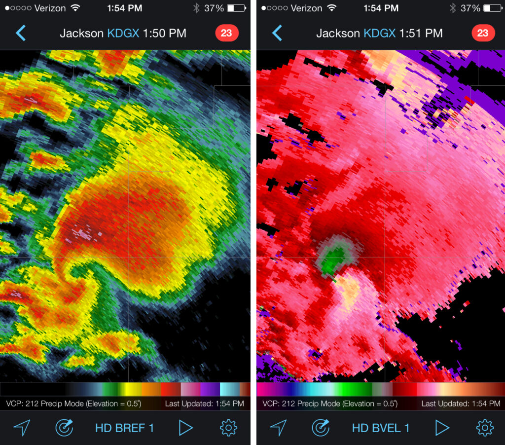
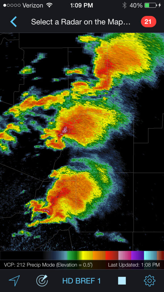
[Edit/Update 1745Z:] This morning, HRRR was forecasting 2 rounds of convection moving through Mississippi at 18Z and 23Z. Watching radar at 1730Z that first round is definitely firing up. There has been clearing ahead of it and surface heating underway. In particular, a serious looking cell erupting near Indianola. If I were chasing in this crazy terrain, I would be heading north to meet it near Grenada. And then there’s round to toward late afternoon. Hoping people are considering locations of shelters and listening to weather alert radio or TV!
[Edit/Update 1900Z:] A string of several tornado warned supercells have formed from north-central through west central Mississippi. Really hazardous situation. With 40-50 mph storm motions to the east-northeast, I would probably have had opportunity to briefly pace two or three of the northern storms along SR 8 and 9, north of my Kilmichael target then down to Euporea and Hwy 82 before letting the line pass.
[Edit/Update 1940Z:] Kilmichael is now in the direct path of the velocity couplet of a tornado-warned cell. Really hope folks are getting to shelter. I would likely make my way west on Hwy 82 and be ready to fly back east as it crosses the highway, and prepared for it to turn right with a south escape at Stewart.
Results:
Nearest Tornado Report: 8 Miles North-northeast Nearest Severe Report: Same
A lot of strong, isolated supercells across Mississippi today with several communities hit. One of the early, northern cells I was tracking did generate a couple tornado reports just north of Kilmichael.
Another long track tornado 38 miles to the southeast generated 5 reports before winding up in Louisville. Unclear if that’s the same one that ended up in Columbus later in the afternoon/evening.
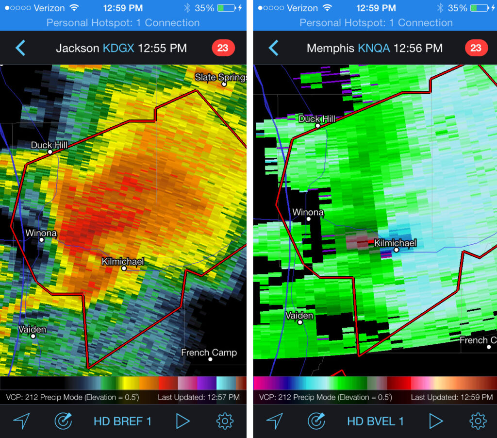
The radar presentation of three of the supercells over the center of the state by midday was unbelievable.