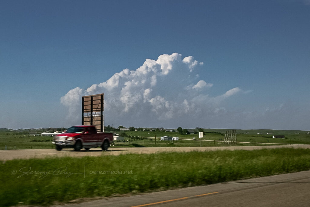
May 22nd, 2010, was the second day of my first storm chase on the plains. When my daughter and I checked out of our hotel in Chadron Saturday morning, I had no idea what an incredible day this would be. Forecast models showed the triple point positioned across north central South Dakota by afternoon with ample moisture, huge CAPE, and shear favorable for tornadic supercells. The cap was sturdy but there was hope that it would erode enough to allow storms to reach their potential.
Our first destination was Pierre, SD. When we arrived, I tried to find a book store where I could pick up a DeLorme South Dakota Atlas, but we were foiled. The manager at one book store said “we really don’t have that many roads in South Dakota”…heheh. Cumulus were beginning to fire to the north-northwest and we couldn’t waste any more time tracking one down. So we had to rely on our single-page Rand McNally map which gives no clues about local and farm roads.
As we headed north on US-83 at 2140Z, the cumulus field was starting to pull itself together and definitely looked like it was going to beat the cap.
Cumulus congestus from US-83 — 2140Z
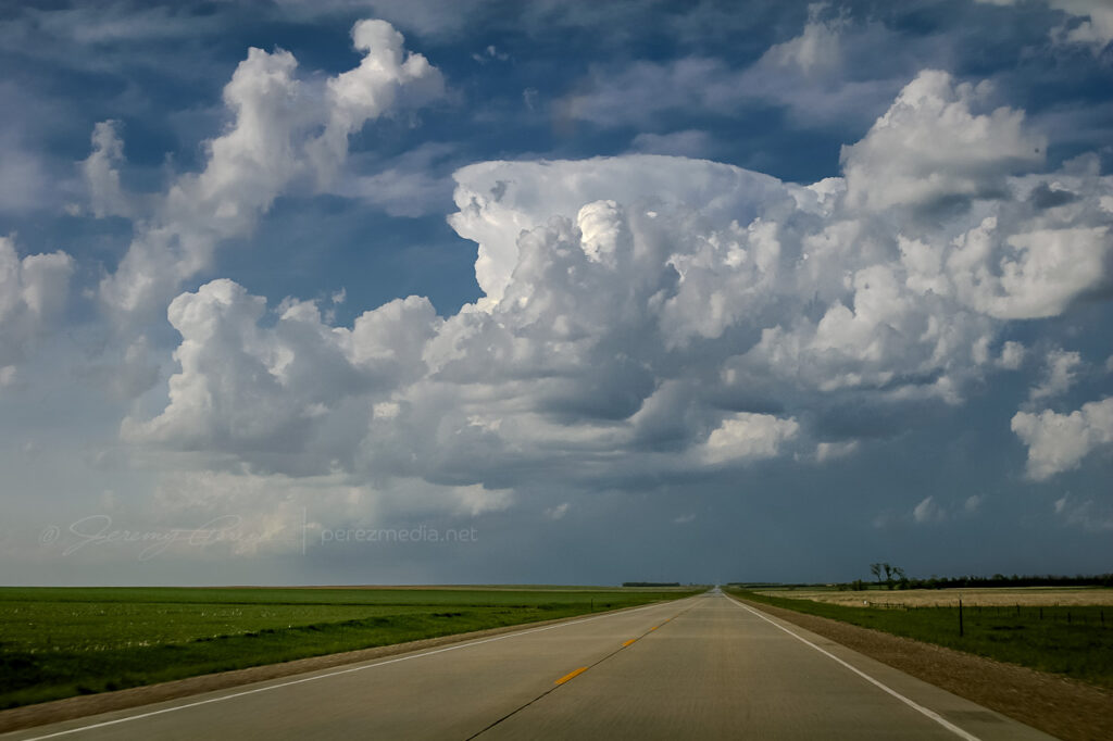
It was exciting to watch it grow and to realize that we were going to be in good position to intercept if it did explode. And it did! By 2215Z, it was pushing up a firm anvil, and by 2235, it was straight ahead, sporting a robust flanking line.
Strengthening supercell from US-83 — 2215Z & 2235Z
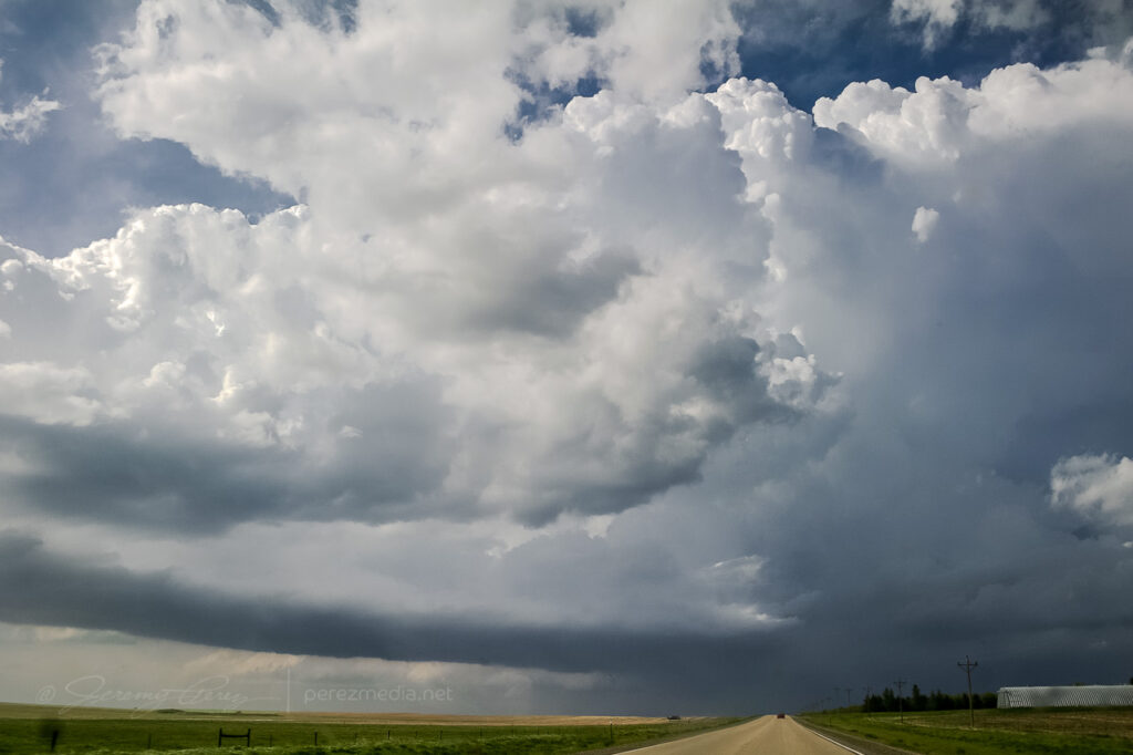
Features under the base began to lower and take shape as we approached the junction with SD-20 where we headed east to gain more ground on the storm.
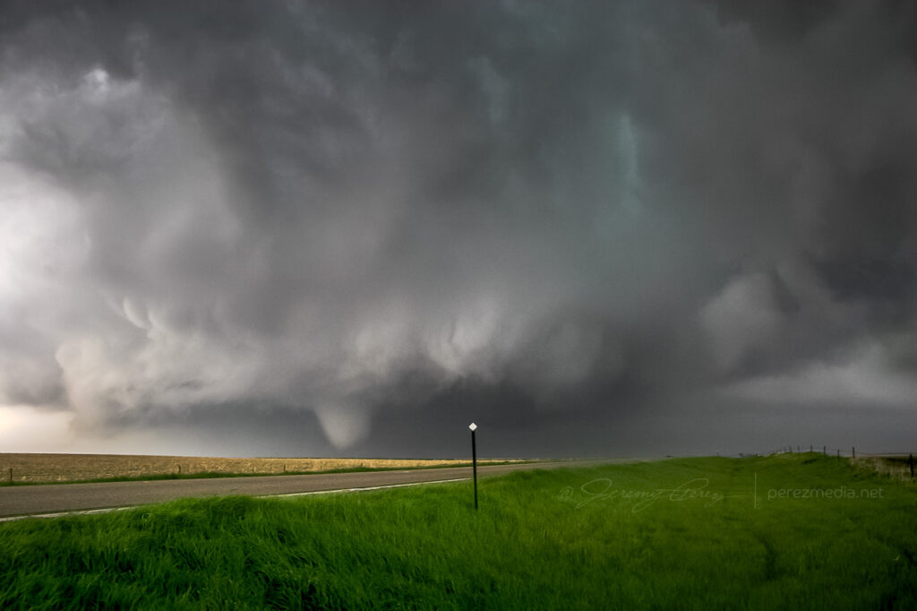
Thirteen miles to the east, we turned back north on SD-47 and by 2300Z, we were watching a foaming wall cloud being fed by a well-defined beaver tail.
Rain free base and beaver tail from SD-47 — 2300Z
It’s difficult to describe the sense of anticipation as we drew close to the point where it would cross the road. I did not want to set up where we would find ourselves beneath the mesocyclone. But I didn’t want to position so far away that we couldn’t see the churning details that were resolving better and better as the storm approached. We found a field access and backed in so we could quickly pull out and reposition if needed.
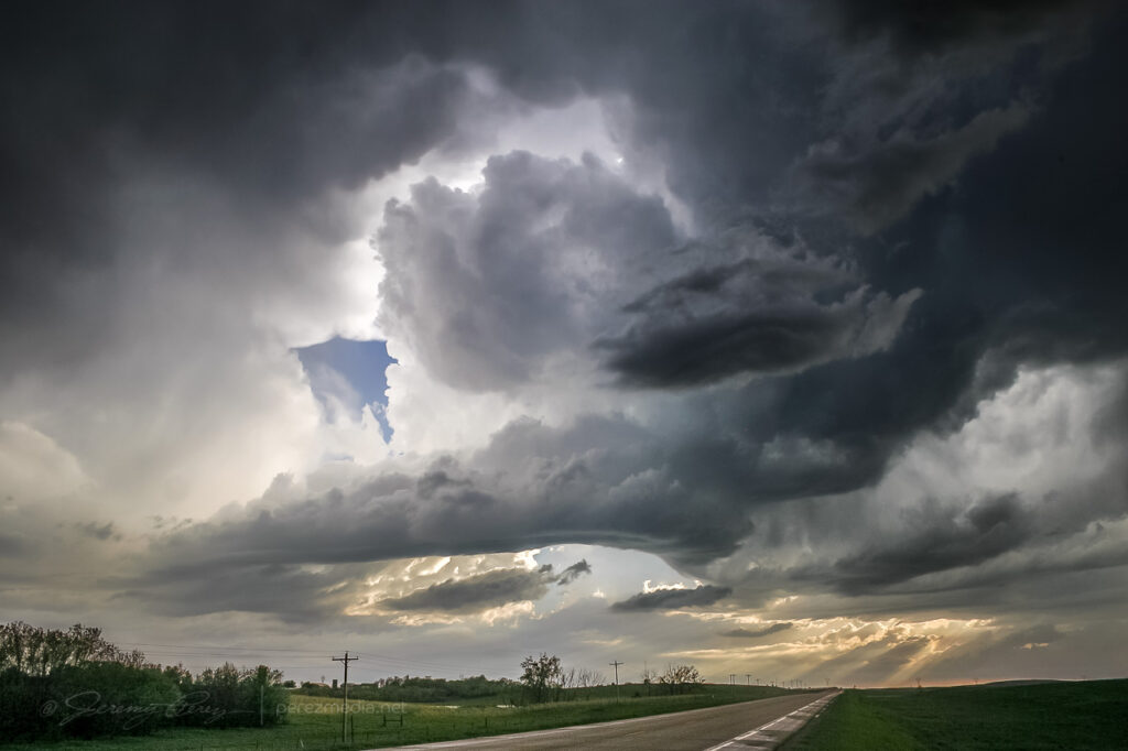
As the meso approached, warm humid wind pushed hard against our backs, urging us to surrender to the storm’s gaping appetite. A golden light seeped beneath the base and RFD began to stir up ragged masses of dust on the far side like a cage going up around the ring. The array of rising, rotating, intertwining structures had me completely awestruck–it made me think of a grand design spiral galaxy in fast motion, the monster at its core threatening to burst to life.
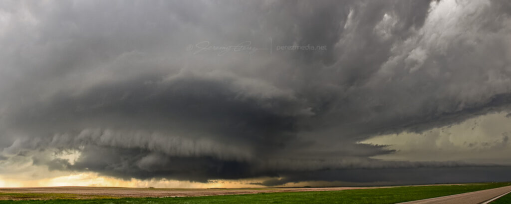
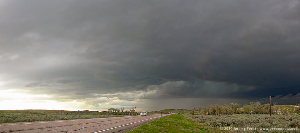
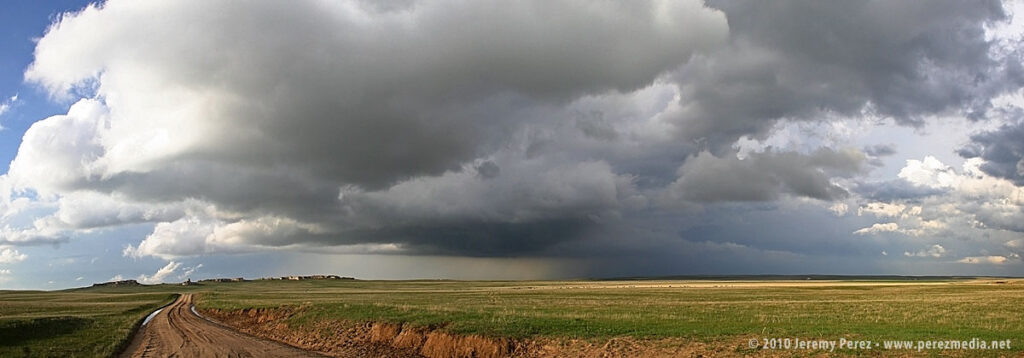
Panorama of the mature and tornado-ready supercell — 2310ZToothy RFD shelf rapidly approaching — 2311Z
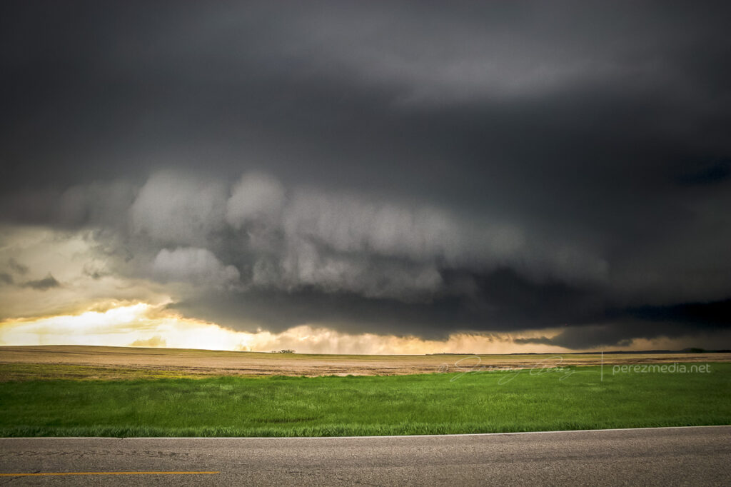
While the heart of the meso was on track to pass north of us, the growing rim of the toothy RFD shelf looked like it was going to pass too close for my sensibilities, so we dropped further south. As we drove, the south side of the meso began to drop and tighten up–things were getting ready to happen before our eyes. We found another pull out about a half mile further south and watched as rain wrapped under the base, while the RFD gust front arced onward.
Surging RFD gust front — 2313Z
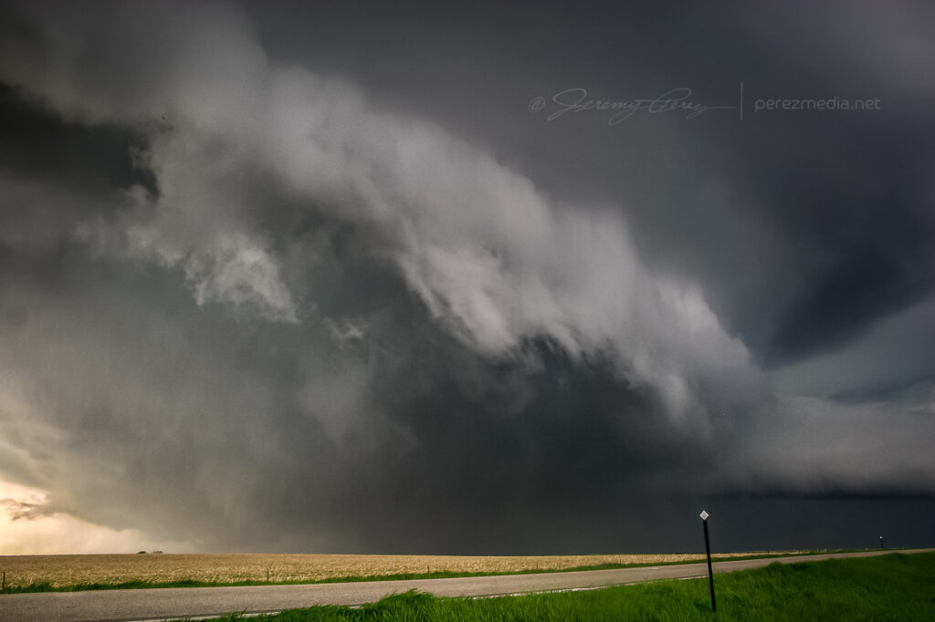
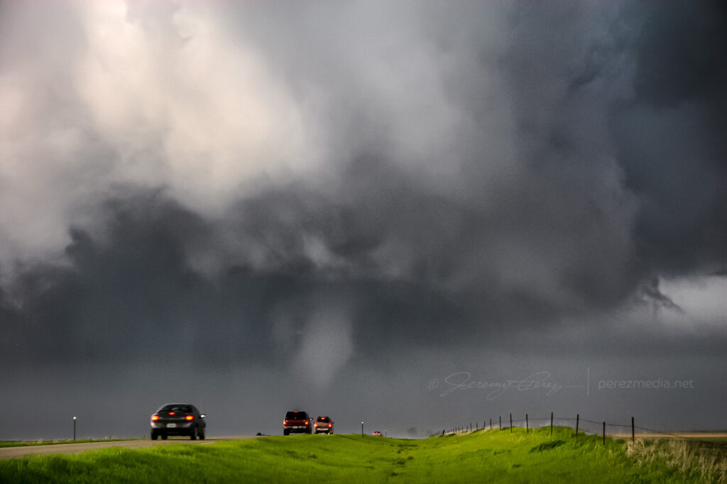
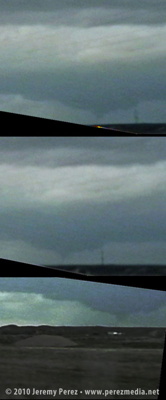
As the mist of precipitation cleared, the hulking mass of a wide cone-shaped funnel emerged from the shadows of its wall cloud (2315Z).
Condensing funnel emerging from the precip — 2315Z
As it slowly moved from left to right, the cone got fatter and then slowly pulled upward, a pale uvula drooping from the singing mouth of the storm.
Drooping funnel — 2315Z
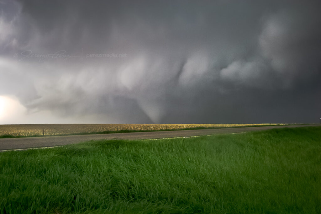
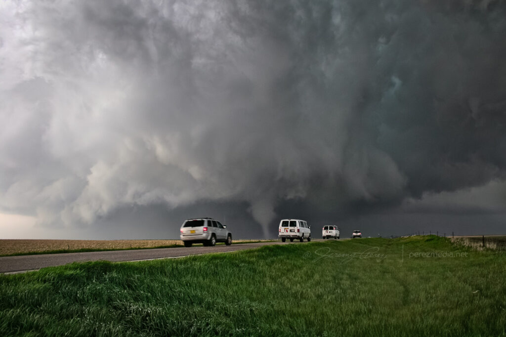
At 2317Z, the bulbous funnel formed a ground churning drillbit. Within seconds, it had finished sampling the farmland and began to degrade into a ragged finger that faded into another curtain of mist. By the time the meso crossed the road (2319Z), the condensation funnel was all but invisible.
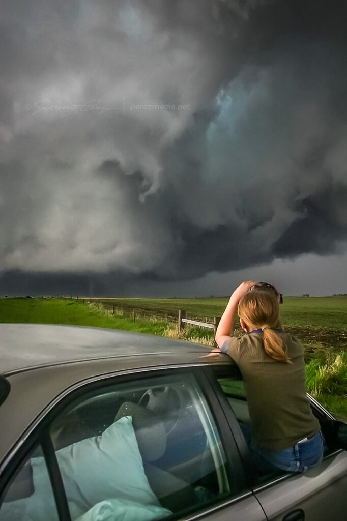
A minute later at 2320Z, the flying curtains of rain parted to reveal the tornado planted firmly to the ground again on the other side of the road.
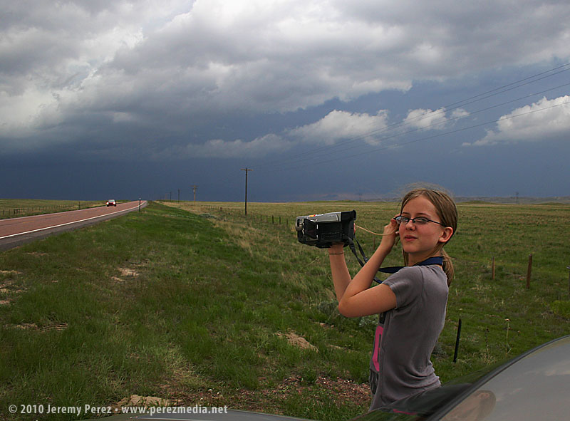
Recondensed tornado — 2320ZMy daughter capturing video of the tornado as it moves off — 2320Z
As the tornado disappeared into the rain and the storm receded, we got back in the car and headed north on SD-47 to find a leaning power pole and vehicles blocking the road where the tornado crossed. As we prepared to turn around, the TIV rolled by heading south.
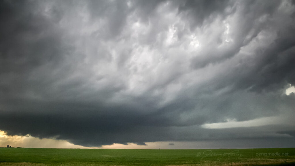
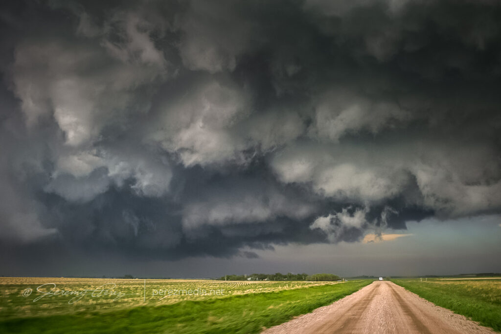
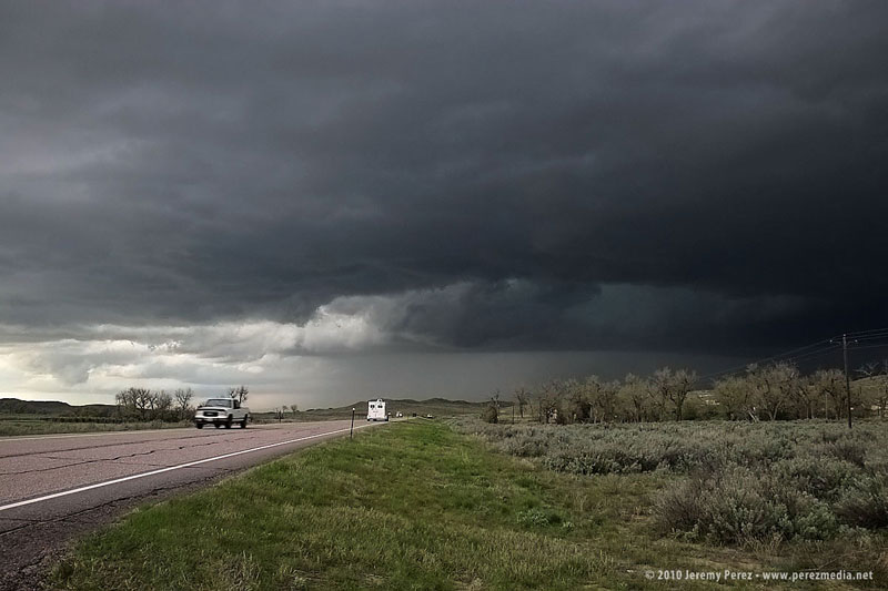
We spent the next 30 minutes looking for another option to get up to US-12 by way of the unpaved grid. As we drove, the extended gust front of the supercell roiled overhead like the unkempt fur of a great hairy beast.
Receding RFD Gust front — 2340Z
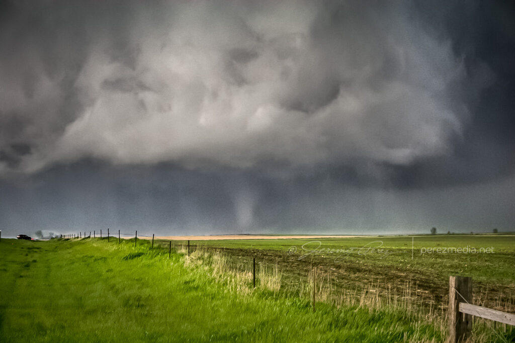
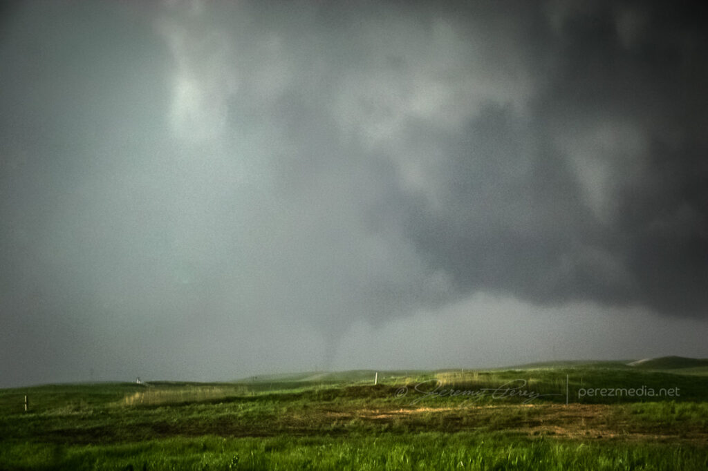
Since we were behind and south of the storm and the roads were dry, I wasn’t concerned about getting stuck in a precarious position, but I was a little frustrated that we were going to lose it. While we were rumbling down these roads, the tornado—unseen by us—had grown to its wedge phase as it passed Bowdle. At 2351Z, we reached a high point that allowed one last look at our next tornado of the day. The distant, silhouetted elephant trunk appeared for mere seconds before disappearing behind more rain.
Distant tornado — 2351Z
We finally reached US-12 and paced eastward. We followed a ragged, brightly lit mass of rain and rotating scud that may have belonged to another inflow region that was forming south of the main cell. We shot photos and video along the way until we were stopped by emergency management vehicles at the junction of US-12 and US-253 at 0022Z.
Ragged, cold side of the storm after calling off the chase — 0022Z
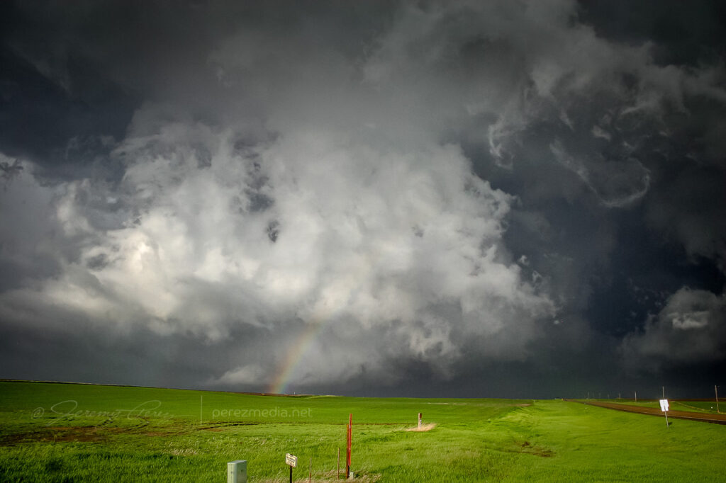
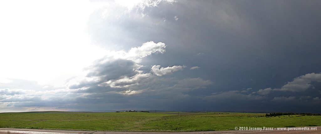
After shooting some more photos, we turned around and headed back toward Pierre. On the way back, we were treated to gorgeous views of other cells soaring into the fertile sky.
Parting views in the wake of the Bowdle supercell
Although it would have been nice to have positioned ourselves to see the wedge that this storm produced, we were beside ourselves excited to have seen such an indescribably powerful and stunning event on our second day of chasing. We drove back to Pierre, worn out and hoping for another great chase in Kansas the following day.
On Thursday night, May 20, we took I-40 from Flagstaff to Albuquerque and then headed north on I-25. We grabbed sleep at rest stops and off ramps along the way. By noon, we were bogged down in traffic in the heart of Denver (what a mess). I figure we lost about an hour trying to pierce the heart of the city instead of taking one of the outside routes.
North of the city, we had a bite to eat at Wendy’s while strongly sheared cumulus tried to pierce the CAP along the front range. The tough part was trying to decide where initiation would take off. Decent CAPE, shear, and a frontal boundary were setting up in southeast Wyoming, so we got back on I-25 and headed north. As we approached Cheyenne, Wyoming, radar showed cells getting healthy along I-25, further north near Wheatland. One cell pulled its act together and started peeling away to the east-northeast. In an attempt to parallel and get ahead from the south, we broke northeast on Hwy 85 toward Torrington and Lingle.
As we approached Torrington, the supercell dominated the sky to the north like a great hen roosting over her clutch with features gradually resolving along the base.
As we entered Torrington and headed toward Lingle on US-85, trees and buildings demolished our view, however, upon clearing some trees about 00Z, we got a sudden and stunning view of a wall cloud and what appeared to be a funnel silhouetted to the northwest. When in silhouette, it’s not possible to determine rotation, so at the time, all we could do was film it and see if we could catch up.
Video frame grabs:
The SPC report later confirmed two tornado touchdowns northwest of Lingle at 23:55Z and 00:01Z. So I’m confident that the feature we saw was indeed a funnel–whether it was a tornado at the time we saw and filmed it, I couldn’t say.
We took US-85 north of Lingle, and caught fractured glimpses of the disintegrating wall cloud between otherwise stunning, hilly terrain. When we finally caught up to it, the wall cloud was gone, although the base was still slowly rotating. A deep, turquoise light emerged from within.
Road options were seriously limited, so we couldn’t follow this one as it tracked to the northeast. So we continued north on US-85 as other storms erupted.
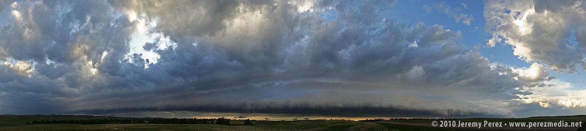
North of Lusk on US-85, we drove beneath an enormous, beautifully lit shelf cloud.
This time lapse video shows motion of the shelf cloud and lowered inflow base:
Illumination beneath this storm was surreal and bathed the Wyoming landscape with a dream-like light.
After nightfall, we spent some time in Lusk, looking for a good place to stay the night and getting pelted with nickel and some quarter sized hail. Every room in Lusk was taken, so we drove on to Chadron, Nebraska and tried to rest up for our next day in South Dakota.
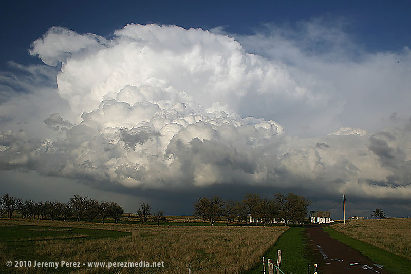
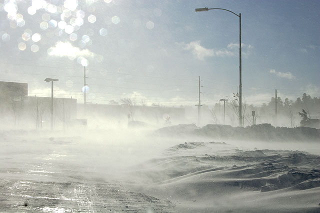
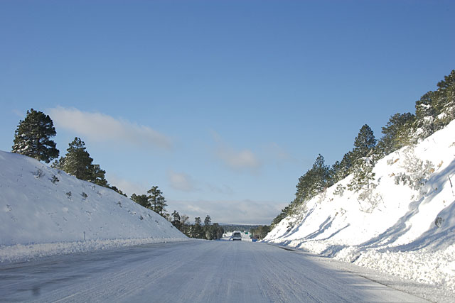
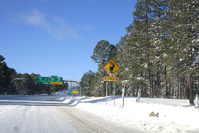
After about 17 inches of snow yesterday, Flagstaff went under a blizzard warning last night. Apparently the first one in about ten years. It blew pretty hard for much of the night, and I could hear things falling over in the carport. Between 11 pm and midnight, power flashes lit up our windows, followed by a darkening of the sky until power was re-routed. That happened three times with the last outage being the longest. We wondered how cold it would get in the house if it lasted all night. We’ve got four bodies and lots of blankets, so it wouldn’t be unmanageable–just uncomfortable.
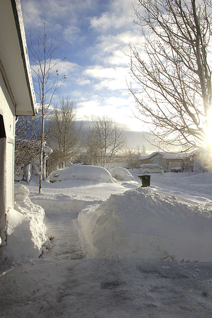
By morning, the snow was done, and the wind had died down. All snow covered surfaces were encrusted in an inch-thick layer of snow-ice. Shoveling the walk and driveway required chopping it into squares like a frosted dessert. My back, shoulders and arms have been complaining all day and will probably be a real mess tonight.
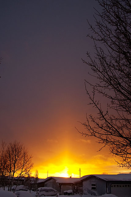
The morning after a big snow is always beautiful. As I worked on the mortared snow, I was treated to an amazing sunrise. All the remaining snow crystals drifting through the air allowed a sun pillar to form.
Some of the roads along the way to work were still suffering from blowing snow obscuring things.
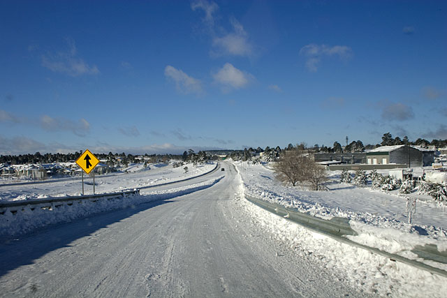
The interstate was a dream to drive. I only saw 2 other cars on the way to work. It sounds like ADOT had closed access to I-40 from Kingman to Holbrook, so the only traffic was local, and that’s me!
Stormtrack.org is a website that serves severe weather enthusiasts. It has a particular focus on forecasting tornadic supercells and chasing them. During the off-season, some of the experienced members post “Chase Cases” where they pull up meteorological data from previous severe weather outbreaks without providing dates, and then gradually posting the information to give everyone a chance to forecast and do a virtual chase. I’m too inexperienced to post anything useful in the discussion, so I thought I’d post my own thoughts and results here as the chase goes on, to see how I do.
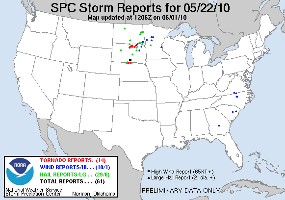
Earlier this week, they posted Chase Case #1 that involved a low pressure system moving out of the rockies into the Dakotas. In an effort to be realistic, I try to assume that I’ll either start my chase from Flagstaff or from Elk City, Oklahoma. Being even more realistic, I figured there was no way I would chase as far north as the Dakotas unless I was really sure I knew what was going on. I saw a dryline positioned in western Kansas and thought I’d go for that as moisture moved up from the south. But I didn’t think about how strong the CAP was in the area, and all I got to see were some small popcorn cumulus in the late afternoon. South Dakota went nuts with severe weather and tornadoes on that day, which turned out to be June 7, 2005.
A cold front is drooping down into the northern plains while a pronounced dryline is positioned southward from the Texas/Oklahoma panhandles. Rich moisture pooled in south Texas with surface winds pushing west-northwest. Directional shear looks really good across Texas and Oklahoma. Soundings don’t look good to me in my limited experience, anywhere except the Del Rio sounding on the Texas/Mexico border where afternoon thunderstorms are blooming in all the moisture.
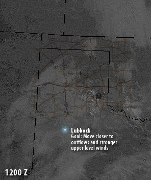
I’m not at all familiar with how a dryline and incoming moisture behave when the cold front is not pushing in from the west. I don’t know if the drooping cold front will help with forcing in Kansas and Oklahoma. So I’m going to start my virtual chase from Elk City and will drive southwest to Lubbock, Texas, to get closer to the incoming moisture, high dewpoints, and to get in the vicinity of the dryline. I’m getting up at 2 AM to make the 4 hour drive and with stops and naps, would probably arrive at 7 am. I’ll find a starbucks and check the 12Z data on my iPod. Then I can decide whether or not to head further south.
I just noticed a couple comments at the site about a possible “Caprock” event. I believe this refers to a geographic feature in west Texas that provides some orographic forcing. So I think if you can get additional help from the dryline, you can get a focal point for storms. We shall see.
If I were to check this before leaving at 2AM, it would probably influence my decision to leave Elk City at all. The weather service text in this update notes potential for severe thunderstorms east of a line from Amarillo to Hill City, KS and on into Nebraska. So, this all seems to set up much further north than I anticipated. The WS update shows that the moisture in the Rio Grande valley will be drawn northward by a 30-50KT low level jet. That’s something I need to pay attention to in the future–is there a low level jet, and if so, is it positioned to maneuver available moisture.
Another issue is that the severe forecast did not extend much further down toward the Rio Grande. One participant in the Chase thread commented that mid level air temps were rather warm in southwestern Texas, and this would stabilize the air. One thing I need to understand is how to determine conducive temperatures at different levels in the atmosphere. Right now, I’m completely lost in this area.
The report does note current convection over Northwest/North-central Texas that could lead to an outflow boundary in Western Oklahoma/East-Texas Panhandle that would greatly enhance severe potential.
Anyway, I committed to Lubbock already, and rather than change the destination, I’ll punish myself by wasting virtual fuel when I’ll likely need to backtrack. I should still well set to easily reposition for action on the southern side of things in the panhandle. I love looking for outflow boundaries on morning satellite. It’ll be interesting to see what shows up at 12Z.
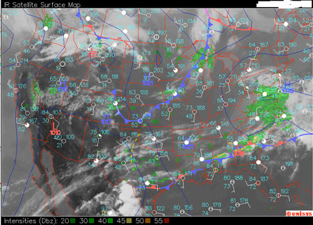
Looking at the 12Z Update satellite imagery, I think I see two outflow boundaries. One crossing the Red River in SW Oklahoma and another in the eastern Texas panhandle. The Temp/Dew Point data in the surface plot seems to show very moist air all over the plains. The dry line drapes from SW Kansas, through the western panhandles, and cuts to the southwest through eastern New Mexico. The 850 Mb chart shows winds pushing the moisture northward across the panhandles. Directional shear looks awesome all the way up, and the 300 Mb chart shows a 70-90Kt jet over the panhandles, Oklahoma and Kansas. CAPE over Amarillo is at a gorgeous 2805.
I’d like to be near the outflow I think I see in the eastern TX panhandle and further north to get closer to better upper level winds. So I’ll make the 2.5 hour drive up to Memphis, TX, arriving there about 10:30 AM where I can check the 15Z update.
OK. I’ve been schooling myself on chart analysis at this excellent site: Weather Prediction Education. There’s a whole lotta work to be done, but I’ll try and dig a little deeper each time.
If things go well on this virtual chase, it won’t be because I got to the right spot for all the right reasons. I didn’t look for Vort Max indicators at 500 mb, check for large tdd at 500/700 mb, look for short waves at 700 mb, look for low level convergence/confluence, or look for upper level divergence/diffluence over unstable air, look for jet streaks at 300 mb…and a million other things. Anyway, at this point, it will be about watching satellite, radar, surface plots, and text updates. So the better map mojo will have to wait for the next chase.
The 15Z Update shows a storm complex over south-central Oklahoma with hail potential, but not worthy of a warning. This may help push more outflow for things to work on later in the day. The dryline is still hanging way back at the New Mexico border and SE Colorado. Convergence isn’t strong along the dryline, but it’s only 9 AM, and the moist surface air hasn’t had a chance to mix out or the winds to pick up. So I’m going to stay where I’m at and grab some virtual nap time in Memphis, TX.
It’s noon, and skies aren’t clearing over the eastern panhandle. Will that kill surface heating enough to deaden the area? Then there’s the dryline. It’s not advancing. I wasn’t sure what it was going to do without a cold front pressing it from the west. Now it looks like there is a surface low spinning over western Colorado, and I don’t know if it will move eastward in time to push the dryline along. In fact, I don’t know if there will be enough convergence along the dryline to make it a good source of strong convection. Winds behind are from the south-southwest, and winds ahead are from the south-southeast.
I think that would bother me enough to start heading northwest where I can get at least closer to clearing skies and the upper stretches of the dryline. I’m driving up to Claude, TX…the name sends a shiver down my spine…
Whew! Didn’t have to stop long in Claude! The 19Z shows that dryline just sitting there, but cumulus are starting to pop along it’s boundary. So onward through Amarillo and up to Dumas, Texas. I should get there by 3 PM and anticipate I’ll want to shoot on west then NW toward Dalhart, Texas where I think I see a dryline bulge. That will depend on development noticed along them way. I’ll have satellite and radar bookmarks ready to go on the iPod so I can check quickly at the nearest Starbucks or hotel parking lot and adjust path in Amarillo, Dumas or elswhere along the way. Now, watch something unanticipated kick off convection where I was at…
Stopping in Amarillo, I check the 20Z update to find that convection is strengthening along the dryline, and it appears to be pushing eastward a bit now. I’ll push on toward Dumas and see how things look from there. I should arrive there about about 3:20 PM (2120).
Something worked here! I approach Dumas as a storm with a great radar signature is blooming over the town. (I doubt I would stop to check radar and would just hop on this storm to see what it’s doing.) Storm motion appears to be a bit north of east at 30 mph. I’ll try following this cell eastward on Rt. 152 through Stinnett (reaching Stinnett at 4:00 PM (2200)) and then up Rt 207 toward Spearman if it seems productive and conditions allow.
At 22Z along Rt. 152, the storm is growing, and it looks like I’m able to keep pace with it as it tears things up 5 miles to the north. The radar signature still looks great.
At 2230Z, I’ve broken off Rt 207 and taken Rt 136 straight north toward Morse, to get closer to this monster as it stradles the Hutchinson/Hansford County line. A beautiful inflow band is coursing in from the east. Wow! Just noticed, there is report of a wedge tornado near Pringle at 2235, moving ENE. That’s on Rt 136, right in front of me!
At 2300Z, Anvils from upstream storms have merged into the cell I’ve been following. My eastward road options are falling apart as I approach the east end of Hutchinson County. I need to decide if this storm is worth following from the west, or if I should head back down Hwy 207 toward Borger to check radar and see if the upstream storms are looking good. I think I had a good ride with this storm, and I’ll head down to Borger and see if anything looks good along the way, or else check radar when I get there (which should be about 2345 if I don’t divert along the way).
Looks like I may have been able to view another strong cell on the way down to Borger, but all remaining tornado reports in this direction happened south of Amarillo in Happy, TX. The storm I was following earlier appeared to put down a couple more tornadoes at the Oklahoma border, and further into Oklahoma. As dusk darkened the sky, I’m not sure what my escape plan would have been with more storms flashing to the southeast. I guess I’d hang out somewhere with wireless and see how they were moving and developing on radar and then time a good path home or to dinner.
Summary
This virtual chase worked perfectly. I caught the Pringle tornado, and it looks like I got to witness some beautiful storm structure along the way. And it was not because I forecasted well. I need to work on a lot on chart analysis. But I also need to understand how boundaries respond to different starting conditions. The dryline fired further west than I thought it would. But then, it wasn’t being pushed along by a trailing cold front. From the first hints of cumulus along the dryline (1800Z) to serious convection (2000Z) to the first supercell (2100) was under 3 hours. So I need to have that ballpark time frame in mind when I see the first signs of cumulus building on the dryline and try to decide what I have time to drive to. It was also helpful to note that the cell I followed formed along the southeast quadrant of the dryline bulge noticed earlier in the day.
Eric Nguyen’s analysis of this day can be found here: 2002 May 5.
Silver Lining Tours report on the chase and how the Pringle storm evolved as it traveled into Oklahoma: Tour 1, Day 10.
Animated GIF showing my virtual chase route and basic rationale.
My first attempt at photographing fluorescent minerals was pretty rough. Although the rocks looked great visually, the camera was less than pleased with the situation. I’m currently using a simple black light to do this, and I quickly realized that the huge amount of visible light produced by these lamps tends to swamp the camera’s CCD/CMOS. It really overwhelmed the actual fluorescing colors in my first batch, and I had to do a lot of heavy overall correction in Camera RAW and LAB color space.
After doing some more research, I realized that this is just what professional grade UV lights are made to overcome. They are filtered to emit very little visible light, so that everything you do see and photograph is the result of genuine fluorescence. Because I’m not ready to invest in that kind of set up, I decided to piece together a more affordable system and see how I like it. I purchased a Long Wave UV Filter from UV Systems and paired it with a Phillips black light bulb from Home Depot. By positioning the filter above the rock, then resting the black light over the filter, I got an immediate improvement. Visually the difference was apparent, although not really spectacular. However, the photographs benefited immensely. Notice the comparison below.
The first image is from my original set of photographs using a GE black light bulb and no filter. The second image is from my latest set of photos using the Phillips black light bulb and the Long Wave UV Fillter. These are original, unprocessed images, opened using the default Camera RAW settings, with only scaling, cropping and labeling applied.
Original photo using GE UV bulb and no filter
Latest photo using Phillips UV bulb and Long Wave UV filter
I’ve replaced the images in that original post with the new photos, including a new angle of the rock to show a striking sliver of white running across one side.
I had basically given up on a piece of fluorescent chalcedony from that original photo session that glowed with a soft orange. The purple overwhelmed it and I couldn’t get rid of it without eliminating the fluorescent orange too. Using the new bulb and filter I got excellent results with it last week. So I’ll eventually get that one posted here too.
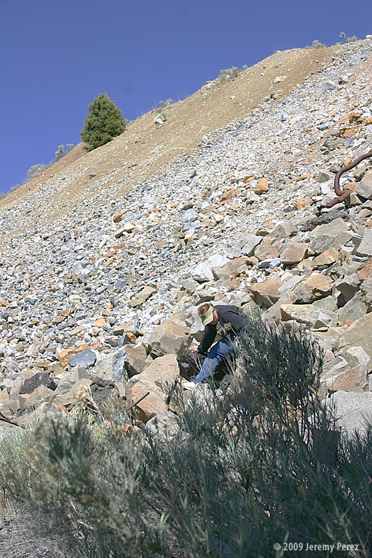
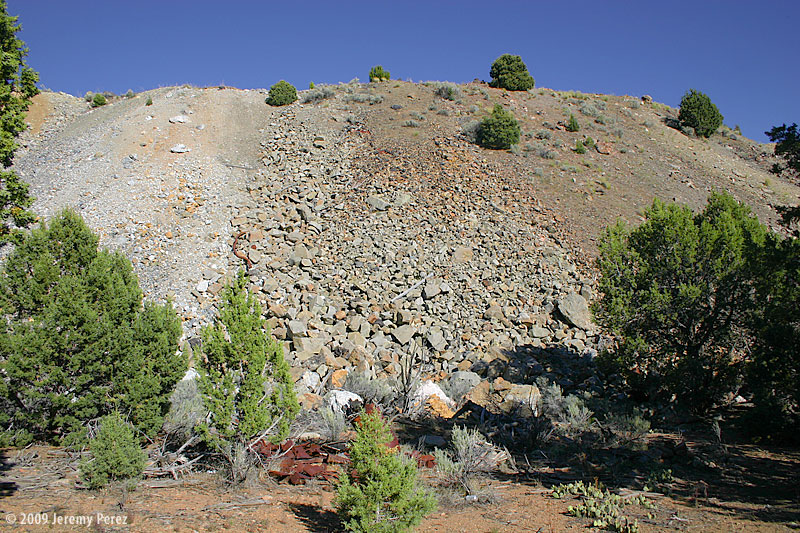
Comstock Mine DumpsAmanda picks through the rocks at the base of the mine dump.
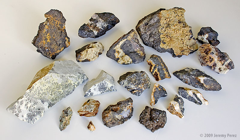
On the last day of a camping and rockhounding trip through Northern Arizona and Southern Utah, we visited a mine dump west of Cedar City, Utah. The rock piles were immense and forbidding. But there was much to be found. The material contained a great deal of magnetite as we later discovered its effect on a compass needle. I still haven’t identified a number of the clear, cream, yellow and orange crystals that adorned the stones we brought back. Several specimens turned out to be fluorescent, glowing orange, yellow and white under long wave UV. This is definitely an area I would like to pick through again.
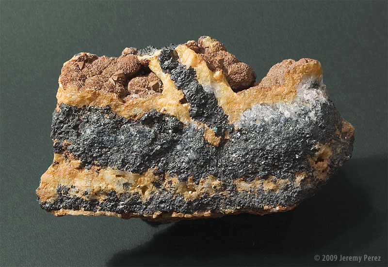
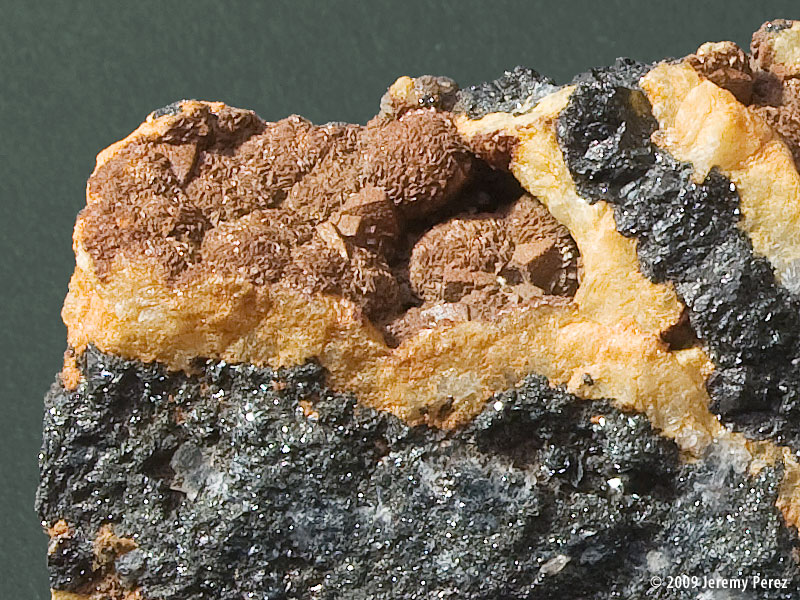
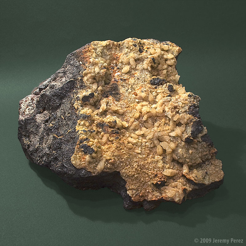
This stone is only mildly magnetic, giving just the slightest tug on a compass needle. Rust colored and clear crystal runs through it. The outer structure of the orange mineral is best seen in the enlarged image. A very small, turquoise colored fleck can be seen in the center of the wide image. I’m not sure if this is contamination from another stone in the rock dump or if it is native to this specimen, but we collected no other material of that color. It is yet another piece in need of testing to try and narrow down the species.
One possibility I’ll look into is whether the orange/brown material is Limonite after Pyrite. The external brown form has emerging crystal forms that appear to be cubic amid striated, botryoidal features.
Mineral Type
Magnetite – Fe+2Fe+32O4 Unidentified Minerals
Size
7.5 x 4.5 x 3 cm
Collection ID
09062107J
Collection Location
Near Comstock Mine, Iron Springs County, Utah, USA 37:36.874 N 113:23.576 W
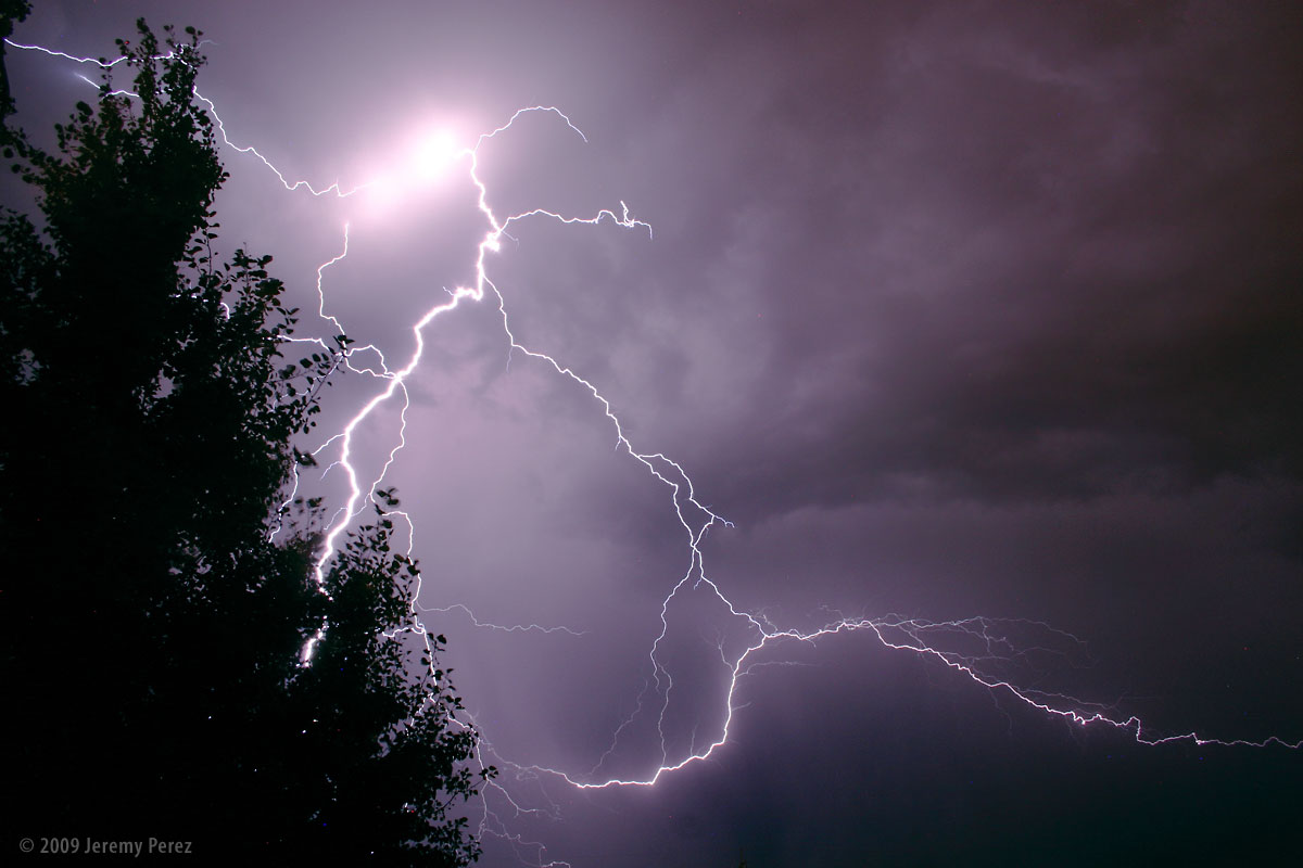
We’ve enjoyed some evening lightning lately–the best kind of fireworks.
This first shot was from Edmond, Oklahoma on August 5, 2009. While sitting outside, we watched as a line of anxious cumulus to the north finally pushed their way through the cap and sprouted a healthy storm. The frequent and constant lightning illuminated the crisp, sculpted edges of the cloud and occasionally revealed bright stitching as warped streamers fell from the sides.
Subject
Cumulonimbus and Lightning
Location
Edmond, Oklahoma, USA
Date
AUG 05, 2009; 10:07 PM CDT
Equipment
Canon EOS 300D + Kit Lens
Settings
30 sec, f/9.0, 18.0 mm, ISO 800
Processing
Noise reduction, power line removal, contrast & color management in Photoshop CS3
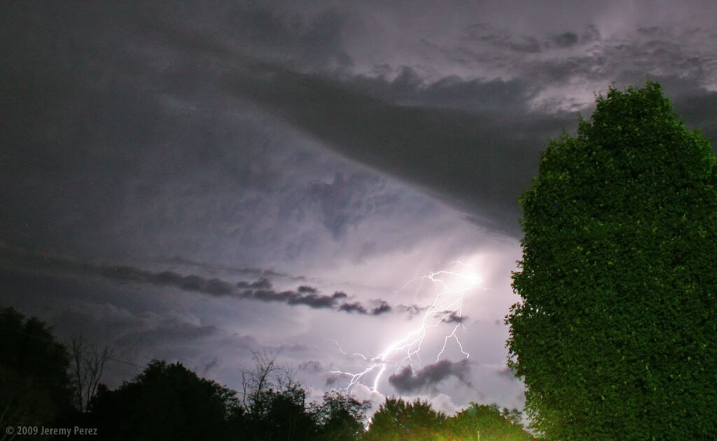
This next shot was taken from home earlier this evening as a storm was pushed north by a line of convection along the Mogollon Rim. Flagstaff doesn’t often see evening lightning displays since the storms fire up earlier in the day before racing off to the lower elevations leaving more stable air behind for the rest of the night. That wasn’t the case tonight and we saw some brilliant webs of light igniting the sky to the south.
Subject
Lightning
Location
Flagstaff, Arizona, USA
Date
AUG 12, 2009; 08:26 PM MST
Equipment
Canon EOS 300D + Kit Lens
Settings
30 sec, f/9.0, 18.0 mm, ISO 200
Processing
Noise reduction, contrast & color management in Photoshop CS3
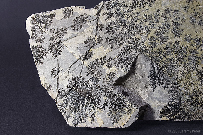
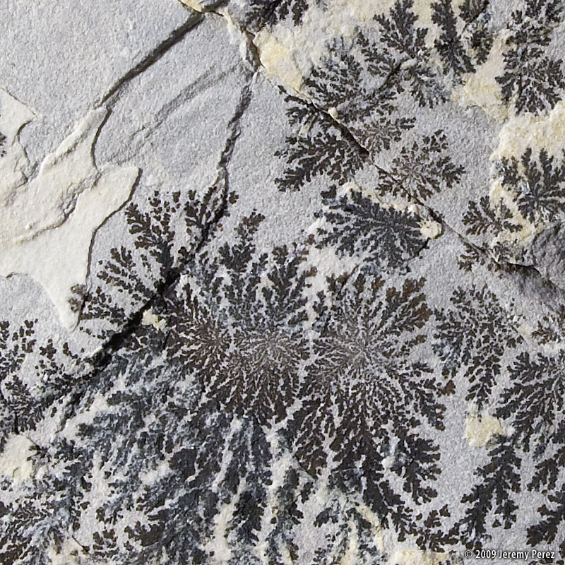
This delicately detailed pair of stones seemed a bit out of place among all the other material at the mine dump. I couldn’t leave them there. A quick scan in a couple field guides suggests Dendritic Pyrolusite. However, it appears that the true mineral identity of the dendrites requires some meticulous laboratory examination…which means I’ll leave this identified generically for now.
Eric Graff has been providing a lot of helpful input on the specimens I’ve posted so far. He notes the following about this one:
Interesting rock! My first guess would be tenorite, CuO, (the only mineral listed from Iron Springs District that is noted for the formation of dendritic patterns).
Morphology:Paper-thin twinned aggregates and laths parallel {100} and elongated [011] (Vesuvius); striated [010] on {100}. Curved plates. Thin shining flexible scales. Stellate groups. Earthy, pulverulent.
Twinning:1. Common on {011}, producing dovetail reentrants and feather-like forms as senn on {100}; also stellate groups andcomplex dendritic patterns. 2. On {100} ?
My second guess would be iron oxide (hematite) as I’ve heard that can also form dendritic patterns. While manganese oxide does frequently form these types of structures, I don’t see any manganese-bearing minerals from that district.
Eric
Thanks Eric!
I’m wondering about scraping some of it off and attempting a flame test on it…
Mineral Type
Dendritic Condensations
Size
21 x 7 x 8 cm, 8 x 7 x 3 cm
Collection ID
09062105J, 09062106J
Collection Location
Near Comstock Mine, Iron Springs County, Utah, USA 37:36.874 N 113:23.576 W
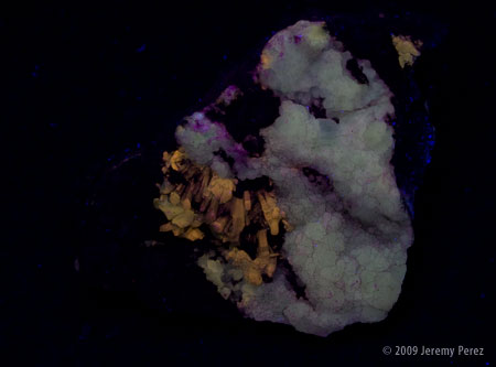
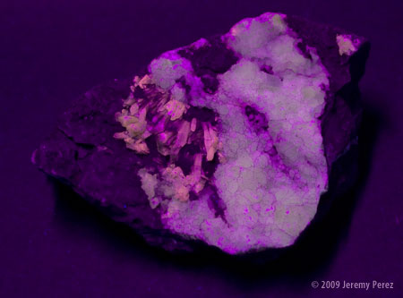
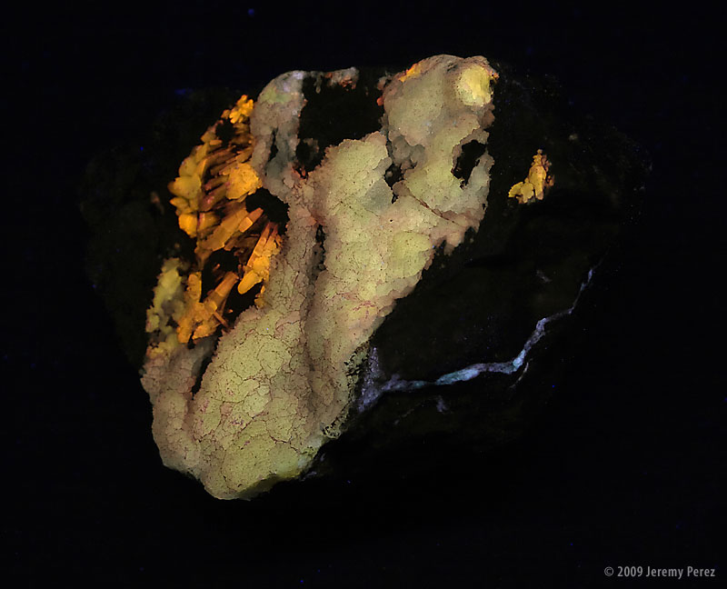
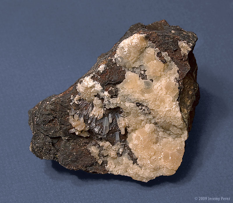
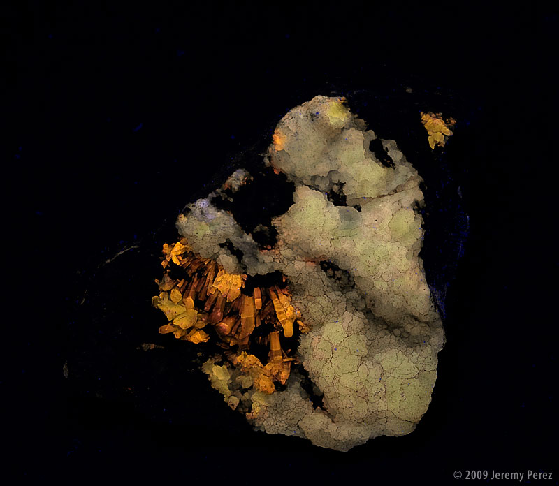
Amanda collected this little chunk of crystal-infused magnetite. It featured two different types of crystaline structures. The best part though was seeing it under a black light. The two different crystal types fluoresced with different colors: yellow and orange. Additionally, some less prominent material exhibited a white fluorescence. It should be interesting working on identifications for this one.
The LW Ultraviolet images can be seen below each of the white light views. Visible in the second set of images is a beautiful, thin vein of the white-fluorescing material along a less exposed edge of the stone. This was my second attempt at black light photography. It turns out to be pretty tricky. My first set of image exposed a huge amount of visible purple from the light that didn’t seem as prominent visually. A lot of heavy color balance gymnastics in the camera RAW conversion process brought it back to something that was workable. Further work in the LAB color space while looking at the rock under black light was also required to take it the rest of the way.
After doing some more research, I picked up a Long Wave UV Filter from UV Systems. I also picked up an 18″ black light bulb manufactured by Phillips since it apparently has a higher density of UV compared to visible emission. Placing the LW UV filter across the bulb produced a noticeable reduction in visible purple and the photographs turned out much better. I didn’t need to horse around with color balance in RAW or LAB. The only issue was some of the crystal faces that reflected the light directly into the camera still possessed a purple appearance, and I needed to use the selective color filter to remove that. The images you see here are a result of that 2nd set of photographs.
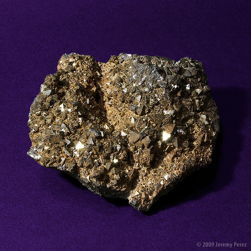
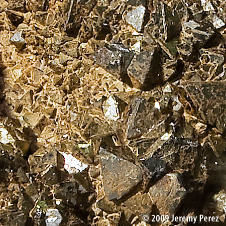
This piece of magnetite possessed the largest crystals of those we found on July 21st. Although, even at that, the longest edge on any of the crystals is no more than 6 mm.
Mineral Type
Magnetite – Fe+2Fe+32O4
Size
6.5 x 5.5 x 2.5 cm
Collection ID
09062101J
Collection Location
Near Comstock Mine, Iron Springs County, Utah, USA 37:36.874 N 113:23.576 W
Collection Date
June 21, 2009
Testing Results
Magnetism: Positive, weak Streak: Dark Gray Hardness: 3-6
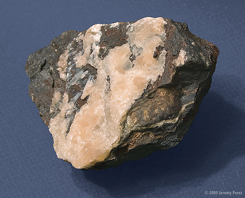
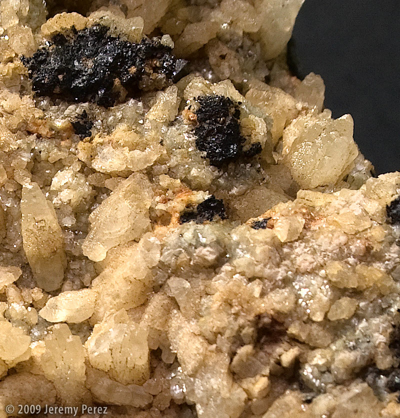
This is one of several magnetite rocks we collected from one of the rock dumps near the Comstock Mine in Iron Springs County, Utah. I’m working on identifying the orange crystals and will update this entry when I figure it out. Below is an enlarged view.
Mineral Type
Magnetite – Fe+2Fe+32O4 Unidentified Crystal
Size
11 x 11 x 8 cm
Collection ID
09062102J
Collection Location
Near Comstock Mine, Iron Springs County, Utah, USA 37:36.874 N 113:23.576 W
Since October 2004, I have maintained the Belt of Venus website where I have been able to share my enjoyment of amateur astronomy. The treasures that lie deep in the vast cosmos aren’t the only things that capture my fascination. Although we lie enmeshed in an enthralling universe, this thin, beautiful bubble of life is pretty hard to ignore. If you enjoy meteorology, geology, botany, zoology–all of those -ologies, -ographies, and -anies–well, so do I. I am easily distracted. I want this to be a place where I can share some of those interests. The Belt of Venus has taken on a life of its own, and I want to keep it strongly focused, so this is where I will try to explore these other natural wonders as the opportunity arises.


