May 2014 Archives

So much for Virtual Chases. I'm planning to head out to the plains for a few days to try chasing some marginal setups. Not sure if I'll be able to post a forecast ahead of each day, but I'll start with my first opportunity this Sunday.

Target: Northeast Wyoming

With all the frustrations of a flimsy severe weather pattern setting in for the latter half of May, it still looks like there will be isolated/conditional opportunities in the northern plains and elsewhere as a trough moves onshore this weekend and starts cutting off in the southwest early in the week.

For Sunday afternoon/evening, per guidance from NAM, I'm looking at a target in northeastern Wyoming as 40-50 kts of southwest H5 flow moves in over an area of low to mid 50 dew points advects around a consolidating surface low in that target area. A narrow, meridional zone of 1500-2000 j/kg CAPE will develop along the eastern Wyoming border with the CAP weak or open by mid to late afternoon in the northern portion of this ribbon. Today's 12Z NAM forecasts a focal point for convection in this area by 00Z with that area potentially ingesting 100-150 m2/s2 0-1km SRH. Mixed layer LCLs are in the 1500 meter range and heighten quickly the further south you go.

If this plays out well, I might hope to see an isolated, high-based supercell drifting slowly into South Dakota. I have no expectations of anything tornadic with this setup. And if today's 06Z GFS has its way, then I can expect a bust with maybe some elevated showers in South Dakota (GFS keeps surface moisture about a hundred miles further east under stronger capping). 00Z ECMWF agrees better with NAM on placement of moisture and location of precipitation, so I hope that agreement favors my focus on NAM.

This will be my first 2014 chase day during a week of very iffy conditions. I'm definitely concerned that I'm setting myself up for a series of busts, but also excited to take on the challenge.
Virtual Storm Chase - May 14, 2014

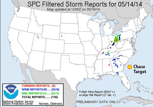
Chase Target: Zanesville, Ohio

I'm relying on guidance from NAM for this forecast and have run out of time to compare with GFS.

A surface low will be consolidating over western kentucky as afternoon progresses. A warm front will be established northeast of the low through southern Indiana, and northern Ohio. A cold front will nudge into western Kentucky/Tennessee and eastern Mississippi. Mid 60 dew points will advect into the warm sector. CAPE values of 1500 j/kg reside from central Kentucky northeastward across southeastern half of Ohio and western Pennsylvania while a pocket of 2000+ j/kg resides over southern Ohio during the afternoon.

Mid level jet placing 40-50 kts of bulk shear over boundaries with enough extending over the warm side to affect convection. Strong 0-1 km SRH resides mainly north of the boundaries, but stronger pockets develop over western Kentucky during early afternoon, and 100+ m2/s2 over southeastern Ohio toward 00Z. Convection is forecast to be ongoing and messy throughout the day, so it's difficult to for me to anticipate how that plays out in this area. My target is in southeast Ohio where 0-1km EHI rises over 1.5 by 00Z and the lid strength index points to wide openings for surface based storms in the area.

Results

Nearest Tornado Report: 94 Miles West-southwest
Nearest Severe Report: 3 Miles Southeast [Hail: 1.5 inch]

ChaseGameResults_20140514.jpg

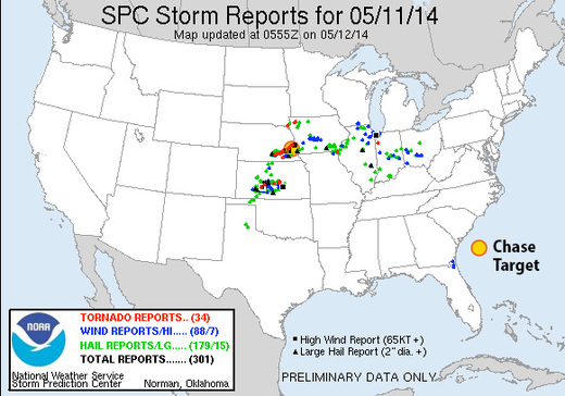
Chase Target: Ashland, Nebraska

A trough over the rockies places 50kt H5 flow from the Texas/Oklahoma Panhandles through Kansas, Nebraska and Iowa by midday. The trough tightens over the afternoon, weakening flow across Iowa to just the extreme southwest part of the state.

A surface low over western Kansas drapes a sharp dryline southward across far east border of the Texas Panhandle and southward from there. At midday, a cold front lines up from the central Kansas/Nebraska border through southwest Iowa and then a warm front up to northeast Iowa. By 00Z, the boundaries have advanced across northeast Nebraska and northern Iowa. East and south of the dryline/cold front/warm front, CAPE values reach or exceed 3000 j/kg by 21Z. LCLs will be rising throughout the warm sector throughout the day, but the southeast Nebraska and southern Iowa have best opportunity to remain at or below 1000 m through 00Z. After that, they lower to 500-750 m across Iowa.

0-1km SRH gets over 100 m2/s2 on the warm side of the boundary, and spiking over 300 m2/s2 immediately on the other side. Hodographs along the warm front have huge, open, clockwise hodographs. Pretty scary actually. Southeast Nebraska at 21Z shows 0-1km EHI over 3 while Iowa waits until 00Z to reach that level. NAM convective forecast puts discrete cells and then ongoing convection in southeast Nebraska as well.

Results

Nearest Tornado Report: 10.9 Miles Northwest
Nearest Severe Report: 9 Miles West [Wind: 60 MPH]

ChaseGameResults_20140511.jpg

A monster supercell erupted in south-central Nebraska and tracked east-northeast along the warm front north of Lincoln, and then north of my target of Ashland before moving into Omaha. It was a long track tornado producer, with the closest tornado report being 10.9 miles northwest of Ashland. A scattering of other tornado reports came from far southeast and far northeast Iowa/far southeast South Dakota, as well as a few from a dryline storm in central Kansas. Hoping no one was hurt by these.

Chase Target: Odessa, Missouri

At 21Z a surface trough will stretch from North Dakota to northeast Kansas, migrating slowly southeast. A cold front will drape from the Nebraska/Iowa border, across east Kansas and into northwest Oklahoma where it transitions to a dryline southward across west Texas. Mid to possibly upper 60 dewpoints will be pushing northward into northern Missouri on 15-20 kt surface winds. As convection fires from 18Z-21Z, MLCAPE values could reach 3000 j/kg east of the front, with NAM aggressively plotting 4000 j/kg in west-central Missouri.

Mid/upper level support takes the form of only slightly amplified flow with pockets of 40 kts at 500 mb across the central plains and into the midwest. The warm sector appears to get its best support across the northeastern three-fourths of Missouri with 50 knots of bulk shear over northwest and north central parts of the state. 0-1km SRH reaches 150 m2/s2 over the northwest quadrant of Missouri as well by 00Z.

NAM forecasts convection firing in this better zone by 21Z with open, clockwise forecast hodographs showing up in both NAM and GFS. Lid Strength Index opens a brief opportunity for surface based storms in the 21Z time frame in this northwest Missouri as well, so placing my target at Odessa, east of Kansas City.

Results

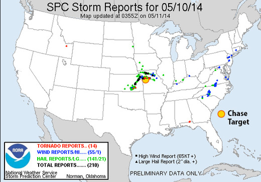
Nearest Tornado Report: 16 Miles North-northeast
Nearest Severe Report: Same

ChaseGameResults_20140510.jpg

Numerous severe storms erupted along the cold front and dryline around 20Z with a few supercells turning right and strengthening. The one that passed just north of Odessa generated a few tornado reports—the nearest 16 miles to the north-northeast.

Virtual Storm Chase - May 9, 2014

Chase Target: Fredericktown, Missouri

I didn't have a lot of time to prepare this. I targeted a location east of the cold front in southeast Missouri where the H5 speed max would provide bulk shear in the 40-50kt range between 21Z-03Z. NAM forecasts dew points in the mid 60s in southwest Missouri with CAPE reaching 2000 j/kg. 0-1 km SRH is not good, reaching maybe into 100 m2/s2 after 00Z, so I don't see more than a very odd chance at tornado potential. NAM forecasts better parameters and reflectivity further north than GFS, so I tried to split the difference between them.

Results

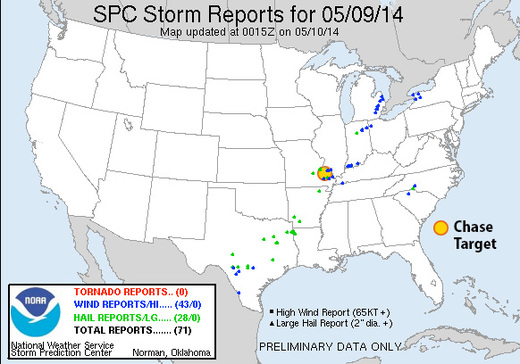
Nearest Tornado Report: None Reported
Nearest Severe Report: 16 Miles North-northwest [Hail: 1 inch] || 25 Miles Northeast [Wind: Roof off house]

ChaseGameResults_20140509.jpg

Insolation had an early start in my target area, which helped several severe warned and two tornado warned storms pass near Fredericktown. A wind report 35 miles south had this to say:

3 S GREENVILLE Wind Report
County, State: WAYNE, MO
  (marker location is approximate)

Lat.: 37.08, Lon.: -90.45

Time: 2014-05-09 20:00
UTC
Wind Speed: Unknown
TREE LIMBS DOWN AND DAMAGE TO CAMPER AWNINGS AT THE OLD GREENVILLE CAMPGROUND. UNCONFIRMED REPORT OF FUNNEL CLOUD ASSOCIATED WITH DAMAGE. DAMAGE PATH ESTIMATED AROUND O (PAH)

Virtual Storm Chase - May 8, 2014

Chase Target: Litchfield, Minnesota

A surface low migrates from northeast Neblaska to southwest Minnesota. A dryline/cold front drapes from east Iowa through central Kansas and western Oklahoma / central Texal with dew points into the mid 60s in the warm sector. CAPE reaches 2500 j/kg near the triple point through the northwest half of Iowa and southern Minnesota while moving rapidly northward into central Minnesota as the cold front works on occluding the surface low.

The upper trough lifts a 60 kt mid level speed max over the dryline/coldfront/surface low. Bulk shear over the northern two-thirds of this boundary starts at 60 kts at midday and drops to 40-50 kts by evening. 0-1km SRH hits 150 m2/s2 east of the surface boundary and over 200 m2/s2 to the north and northeast of the surface low.

Maximized EHI follows this position from far northeast Nebraska at 18Z to northwest Iowa by 21Z and southeast Minnesota by 00Z with 21Z having the greatest potential, but too strongly capped. Reflectivity forecast shows triple-point storms firing by 00Z in south-central Minnesota with large open hodographs, and marks my target area.

Results

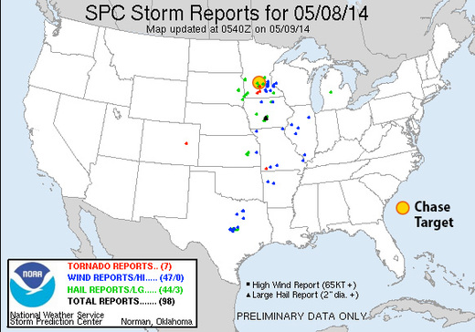
Nearest Tornado Report: 38 Miles South-southeast
Nearest Severe Report: 19 Miles South-southwest [1.5 Inch Hail]

ChaseGameResults_20140508.jpg

The warm front did not lift as far north as I anticipated from yesterday's model runs. However, a couple supercells managed to take advantage of low level helicity along the warm front south of my target area and did produce tornadoes. One of those reports was 38 miles to the south-southeast of Litchfield.

Chase Target: Davidson, Oklahoma

Looking at the southern portion of this setup: it features a fairly neutral-tilt trough over western US with 50-60kt 500 Mb speed max edging eastward over the Panhandles/western Oklahoma/northwest Texas/southwest Kansas. The 18Z NAM forecasts 40-50kt bulk shear over northwest texas to northwest Oklahoma by 00Z and increasing thereafter. The 18Z GFS spreads that out more, but pushes it further northwest. An elongated surface trough is forecast to tighten up from northeast Colorado to eastern Nebraska with a dryline retreating westward during the afternoon/evening and ending up at 00Z from western Iowa through central Kansas, southwest Oklahoma and south from there into Texas with mid 60 dewpoints in place. CAPE values range from 2000 (GFS) to 3000 (NAM) j/kg east of the dryline by mid-late afternoon. By 00Z, GFS breaks out convection north of the Red River while NAM plants south of the Red River. Both models/areas feature widening hodographs toward and after sunset. NAM features EHI building from 1.0-3.0 around and south of Vernon Texas from 00Z-03Z with 0-1km SRH approaching 300 m2/s2 by 03Z. LCLs start to drop toward 1,000 meters from 00Z-03Z as well.

[Update 1515Z:] Latest NAM, HRRR and RAP reflectivity forecasts are showing some differences in where convection will initiate and strengthen. 06Z and 12Z NAM fires things up right over my target area. RAP and 12Z HRRR however are lighting up further east at mid afternoon with HRRR firing a weaker second round over my target area a couple hours later. It seems like HRRR is anticipating the dryline sitting further east around 21Z when convection initiates, and then the dryline starts retreating right after that. I'm interested to see if SPC nudges the risk area eastward or not. The difference is about 50 miles, so if I were there, I'd be pleased to just sit in my current location, watch the dryline mark itself out, and then adjust if needed as cumulus gets more agitated.

Results

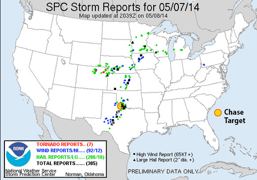
Nearest Tornado Report: 30 Miles Southeast
Nearest Severe Report: 18 Miles East-northeast [1.5 Inch Hail]

ChaseGameResults_20140507.jpg

Storms that fired near southwest Oklahoma did fairly well toward 00Z with a tornado-warned cell crossing the Red River near my target area. Apparently there was a spotter report of a tornado near Burkburnett, but I haven't seen it posted to SPC storm reports as of 0500Z.

[Update May 8, 2014:] SPC is still updating storm reports, and have now plotted two new tornado reports: 30 miles southeast of my target, near Burkburnett, and 40 miles north-northeast, in the Wichita Mountain Wildlife Refuge.